Severe Thunderstorm Warning Issued for Parts of North Texas
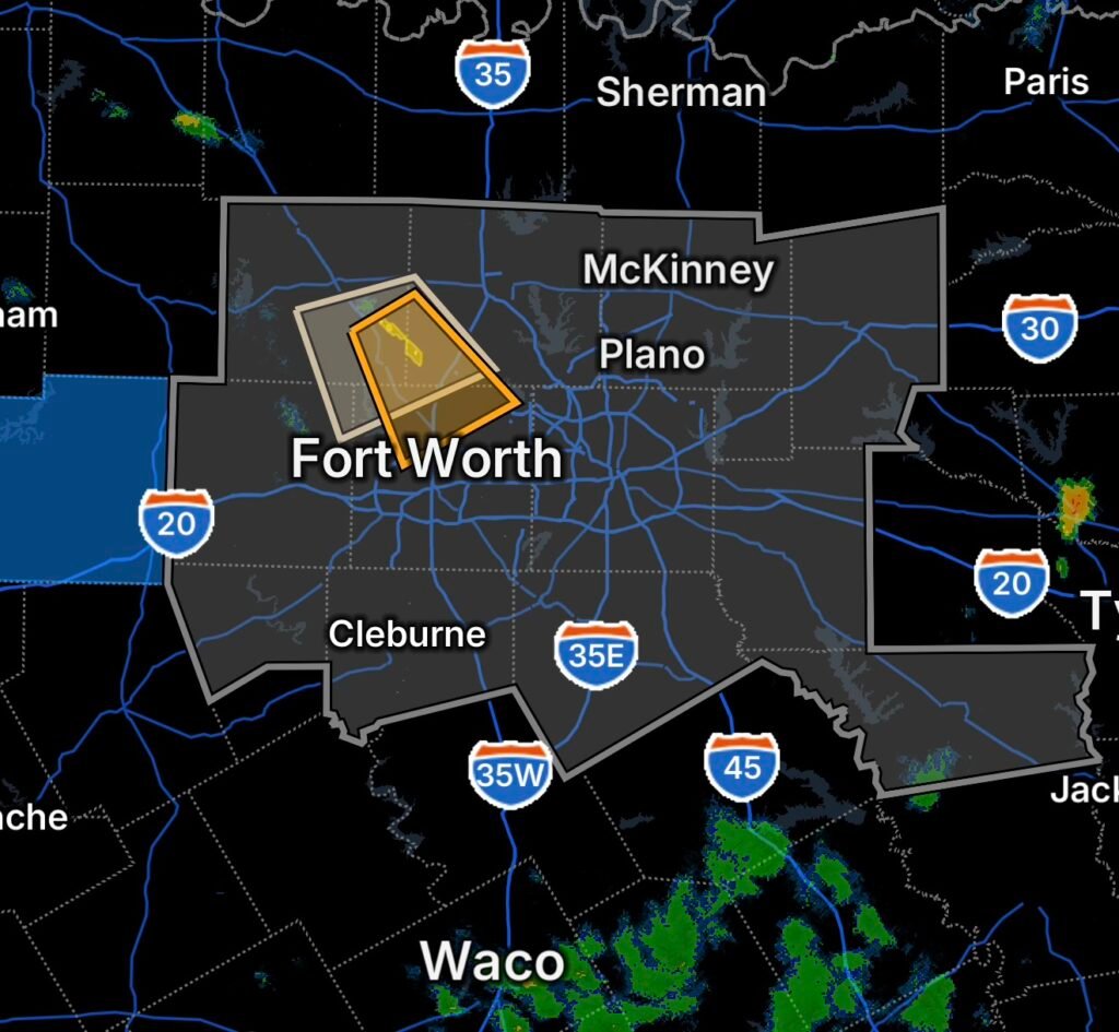
Severe weather is affecting portions of North Texas on Wednesday, August 26, 2026, with a Severe Thunderstorm Warning issued for southeastern Wise County, southwestern Denton County, and northern Tarrant County.
Residents in and around the warned areas should be prepared for rapidly changing conditions, including strong thunderstorm winds, frequent lightning, heavy rainfall and potentially damaging hail. Severe thunderstorms can intensify quickly, so people should move indoors as soon as threatening weather approaches.
The National Weather Service Fort Worth/Dallas office provides detailed local forecasts and warning information for North Texas. (National Weather Service)
Areas Being Monitored
The current weather situation includes several North Texas counties and surrounding communities.
Southeastern Wise County
Thunderstorms moving across southeastern Wise County can produce sudden wind gusts, intense rainfall and lightning. Residents should remain indoors during the strongest storms and avoid unnecessary travel.
Southwestern Denton County
Southwestern Denton County is also included in the severe-weather threat. Heavy rain may quickly reduce visibility and create hazardous driving conditions.
Northern Tarrant County
Northern Tarrant County may experience strong thunderstorms as storms move through the region. Residents should monitor weather alerts closely because storm intensity and location can change rapidly.
Special Weather Statement Covers Parker, Denton, Tarrant and Wise Counties
A Special Weather Statement is also being highlighted for portions of Parker County, Denton County, Tarrant County and Wise County.
A Special Weather Statement is generally used to highlight weather that may be hazardous but does not meet the criteria for a warning. However, conditions can evolve, particularly when thunderstorms are developing nearby.
Residents should continue monitoring radar and official alerts even if their location is not currently inside a Severe Thunderstorm Warning.
Dallas-Fort Worth Air Quality Alert
The weather threat is occurring alongside an Air Quality Alert/Ozone Action Day for the Dallas-Fort Worth area.
The Texas Commission on Environmental Quality issued an Ozone Action Day for Wednesday, August 26, because atmospheric conditions are favorable for elevated ozone pollution. The forecast indicated that ozone could reach the lower end of the Unhealthy for Sensitive Groups range in parts of the northern Dallas-Fort Worth area. (National Weather Service)
Sensitive individuals should consider limiting prolonged or strenuous outdoor activity when ozone concentrations are highest, particularly during the afternoon and early evening.
The air-quality situation is separate from the thunderstorm warning, meaning residents may need to pay attention to both weather hazards and air pollution conditions.
Palo Pinto County Power Outage Concerns
Palo Pinto County is facing another serious emergency as the Ross Fire continues to burn across North Texas.
The rapidly expanding wildfire had reached approximately 80,000 acres and 12% containment by Wednesday, August 26, according to reports citing Texas A&M Forest Service information. The fire began in Palo Pinto County and spread toward neighboring Jack County. (CBS News)
Power infrastructure and other utilities can be affected during large wildfire operations, evacuations and emergency response. If you are experiencing a power outage in Palo Pinto County, check your electric provider’s latest outage information and stay away from any downed or damaged power lines.
The Ross Fire has also resulted in road closures, school impacts and evacuation-related operations. (Houston Chronicle)
Why North Texas Weather Can Change So Quickly
North Texas sits in a region where intense summer heat, atmospheric boundaries and moisture can interact to produce rapidly developing thunderstorms.
When sufficient instability and moisture are present, thunderstorms can strengthen quickly. Stronger storms can generate powerful downdrafts, which transfer high-altitude winds toward the surface and can produce damaging wind gusts.
Heavy precipitation can also cause rapid visibility reductions and localized flooding, especially where rainfall rates become intense.
At the same time, hot and relatively stagnant conditions can contribute to ozone formation across the Dallas-Fort Worth metropolitan area. TCEQ’s forecast specifically identified warm temperatures, light winds and afternoon sunshine as factors supporting higher ozone levels on August 26. (TCEQ)
North Texas Severe Weather Safety
If you are inside a Severe Thunderstorm Warning:
- Move indoors immediately.
- Stay away from windows.
- Do not shelter beneath trees during lightning or strong winds.
- Unplug sensitive electronics if conditions allow and avoid contact with electrical equipment during the storm.
- Never drive through flooded roadways.
- Slow down significantly if heavy rain reduces visibility.
- Increase following distance when driving in severe weather.
- If hail begins, move into a sturdy building or covered location.
- Treat all downed power lines as energized and stay away.
If a warning is issued for your exact location, do not wait for the storm to become visibly severe before taking shelter.
What Residents Should Watch Next
The combination of thunderstorms, extreme summer heat, poor air quality and the ongoing wildfire emergency makes Wednesday a particularly active weather day across North Texas.
Residents in Wise, Denton, Tarrant and Parker counties should keep weather notifications enabled and monitor changing conditions throughout the day.
Meanwhile, residents near the Palo Pinto County wildfire should follow evacuation instructions from local authorities. The Ross Fire remains an active and rapidly changing emergency, with officials continuing firefighting and public-safety operations. (CBS News)
Radar Watch HQ Final Thoughts
North Texas residents are dealing with multiple hazards at once on August 26, 2026. Severe thunderstorms are threatening portions of Wise, Denton and Tarrant counties, an Ozone Action Day is affecting the Dallas-Fort Worth area, and the massive Ross Fire continues to create serious concerns in Palo Pinto County.
The most important step is to stay informed and act early. Weather warnings can change quickly, and wildfire conditions can change even faster. Keep multiple ways to receive emergency alerts, avoid unnecessary travel during severe storms, and follow local emergency-management instructions.
Stay weather-aware, stay prepared, and stay safe, North Texas.

Affiliate Disclosure: As an Amazon Associate, Radar Watch HQ earns from qualifying purchases.
Radar Watch HQ Top 5 Essential Emergency Preparedness Picks
Whether you’re preparing for severe thunderstorms, flash flooding, hurricanes, wildfires, or extended power outages, these five emergency essentials can help keep your household safer when severe weather strikes.
A portable power station provides reliable backup electricity during outages, allowing you to power phones, medical devices, laptops, lights, small appliances, and communication equipment without fuel.
Best for:
- Extended power outages
- Severe thunderstorms
- Hurricanes
- Winter storms
- Wildfires
2. Flood Protection Barriers & Sandless Flood Bags
Flood barriers help divert or absorb water before it enters garages, doorways, and low-lying areas. They deploy quickly and can help reduce property damage during flash flooding.
Best for:
- Flash Flood Warnings
- Heavy rainfall
- River flooding
- Coastal flooding
3. Rechargeable LED Flashlights
Bright, dependable flashlights are essential when the power goes out. Rechargeable or solar-powered models provide long-lasting illumination for navigating safely indoors and outdoors.
Best for:
- Overnight power outages
- Emergency evacuations
- Storm damage inspections
Keep phones, tablets, weather radios, and USB-powered devices charged when the electrical grid is unavailable. A solar power bank offers an additional charging option during prolonged emergencies.
Best for:
- Communication during outages
- Emergency weather alerts
- Travel and evacuation
A NOAA Weather Radio delivers official weather alerts directly from the National Weather Service, even when cellular networks or internet service are unavailable. It remains one of the most dependable ways to receive life-saving warnings.
Best for:
- Tornado warnings
- Severe thunderstorm warnings
- Flash flood warnings
- Hurricane alerts
- Winter storm emergencies
Why Radar Watch HQ Recommends These Essentials
At Radar Watch HQ, preparedness is just as important as staying informed. These five emergency essentials can help you stay connected, protect your property, and safely navigate severe weather events. Having supplies ready before storms arrive allows you to respond quickly when warnings are issued and conditions begin to deteriorate.