Severe Weather and Air Quality Threats Expand Across Colorado
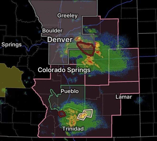
Colorado is dealing with several weather hazards Wednesday, August 26, as thunderstorms bring the potential for flash flooding, damaging winds, hail and additional heavy rainfall while an ozone alert affects much of the Front Range. A Severe Thunderstorm Watch is also covering a large portion of northeastern and east-central Colorado. (National Weather Service)
For residents, the combination of storms and poor air quality means conditions can change quickly. In addition, burn scars can become especially vulnerable to rapid runoff when thunderstorms drop heavy rain over recently burned terrain.
Flash Flood Warning for Adams, Arapahoe and Elbert Counties
A Flash Flood Warning is the most urgent concern when it is active because flooding can develop rapidly with little time to react.
Heavy thunderstorms can overwhelm drainage systems, send water across roadways and produce dangerous rises in creeks and normally dry channels. Areas that receive repeated thunderstorms are particularly vulnerable because the ground may have limited capacity to absorb additional rainfall.
Residents in Adams County, Arapahoe County and Elbert County should monitor the latest warnings and be prepared to move to higher ground if flooding begins.
Never Drive Through Floodwater
Even shallow-looking water can hide washed-out pavement, debris or rapidly moving currents.
Turn around, don’t drown. If a roadway is covered by water, find another route rather than attempting to cross.
Severe Thunderstorm Watch Covers Much of the Front Range
A Severe Thunderstorm Watch includes:
- Adams County
- Arapahoe County
- Boulder County
- Broomfield County
- Denver County
- Douglas County
- Elbert County
- Jefferson County
- Larimer County
- Lincoln County
- Morgan County
- Washington County
- Weld County
The watch means conditions are favorable for severe thunderstorms; it does not mean every location will experience severe weather.
The National Weather Service reported that the watch remains in effect through the evening for portions of east-central and northeast Colorado. (National Weather Service)
Main Storm Threats
The strongest storms can produce:
- Large hail
- Damaging wind gusts
- Torrential rainfall
- Frequent lightning
- Rapidly developing flooding
A recent Denver-area storm statement reported a strong thunderstorm capable of producing 50-mph wind gusts and nickel-size hail. (National Weather Service)
Because storms can intensify quickly along the Front Range, residents should keep weather alerts enabled and move indoors when thunder is heard.
Air Quality Alert Covers Denver and the Front Range
Storms are not the only concern.
An Ozone Action Day Alert is in effect for Douglas County, Jefferson County, Denver County, western Arapahoe County, western Adams County, Broomfield County, Boulder County, Larimer County and Weld County.
The alert runs from 4 p.m. Wednesday, August 26, through 4 p.m. Thursday, August 27. Ozone concentrations could reach the Unhealthy for Sensitive Groups category during afternoon and evening periods, particularly across western portions of the Denver metropolitan area and nearby foothills. (National Weather Service)
What Residents Can Do
During periods of elevated ozone:
- Reduce prolonged outdoor exertion during afternoon and evening hours.
- Limit unnecessary driving when possible.
- Consider carpooling or other transportation options.
- Follow local air-quality guidance.
- Pay attention to symptoms such as breathing discomfort.
The ozone concern is particularly important for people who may be more sensitive to poor air quality.
Aspen Acres Burn Scar Remains Vulnerable to Flash Flooding
Another important concern is the Aspen Acres burn scar, where a Flash Flood Watch remains in effect.
The National Weather Service says excessive rainfall could produce flash flooding and debris flows over the burn scar. The watch is in effect through the evening. (National Weather Service)
Why Burn Scars Flood So Quickly
Wildfires can dramatically change the landscape.
After intense burning, vegetation that normally slows rainfall runoff may be gone. Heat from a wildfire can also alter soil characteristics, reducing the ground’s ability to absorb water.
As a result, thunderstorms can send large amounts of water, mud, rocks and debris downhill very quickly.
That means residents downstream from the Aspen Acres burn scar should take flooding alerts seriously, even if rainfall at their immediate location does not appear particularly heavy.
A Multi-Hazard Weather Situation Across Colorado
Wednesday’s weather setup demonstrates why residents should monitor more than one type of alert.
The same region can experience severe thunderstorms and flash flooding while also dealing with elevated ozone levels. Meanwhile, burn-scar areas can face an additional risk of debris flows.
The latest National Weather Service information shows thunderstorms continuing to affect portions of the Front Range, with flood and severe-weather products being issued as storms evolve. (National Weather Service)
Colorado Severe Weather Safety
When a Severe Thunderstorm Warning is issued, move inside a sturdy building and stay away from windows.
If flooding threatens your location, move to higher ground immediately. Do not wait for water to rise around your vehicle or home.
For burn-scar communities, be especially alert for sudden water, mud and debris moving through normally dry drainage areas.
Also remember that a watch means be prepared, while a warning means take action.
Radar Watch HQ Preparedness Essentials
Keep the following ready during an active severe-weather period:
- Multiple ways to receive emergency alerts
- A fully charged phone
- Flashlights and backup batteries
- Emergency drinking water
- Necessary medications
- A basic emergency kit
- A plan for reaching higher ground if flooding develops
Radar Watch HQ Final Thoughts
Colorado is facing a multi-hazard weather situation on August 26, 2026, with flash flooding concerns, a broad Severe Thunderstorm Watch, elevated ozone and heightened vulnerability around the Aspen Acres burn scar.
The most important message is to stay weather-aware. Conditions can change rapidly as thunderstorms develop, strengthen and move across the Front Range.
If a warning is issued for your location, act immediately rather than waiting to see what the storm does.
Stay alert, stay informed and stay safe.

Affiliate Disclosure: As an Amazon Associate, Radar Watch HQ earns from qualifying purchases.
Radar Watch HQ Top 5 Essential Emergency Preparedness Picks
Whether you’re preparing for severe thunderstorms, flash flooding, hurricanes, wildfires, or extended power outages, these five emergency essentials can help keep your household safer when severe weather strikes.
A portable power station provides reliable backup electricity during outages, allowing you to power phones, medical devices, laptops, lights, small appliances, and communication equipment without fuel.
Best for:
- Extended power outages
- Severe thunderstorms
- Hurricanes
- Winter storms
- Wildfires
2. Flood Protection Barriers & Sandless Flood Bags
Flood barriers help divert or absorb water before it enters garages, doorways, and low-lying areas. They deploy quickly and can help reduce property damage during flash flooding.
Best for:
- Flash Flood Warnings
- Heavy rainfall
- River flooding
- Coastal flooding
3. Rechargeable LED Flashlights
Bright, dependable flashlights are essential when the power goes out. Rechargeable or solar-powered models provide long-lasting illumination for navigating safely indoors and outdoors.
Best for:
- Overnight power outages
- Emergency evacuations
- Storm damage inspections
Keep phones, tablets, weather radios, and USB-powered devices charged when the electrical grid is unavailable. A solar power bank offers an additional charging option during prolonged emergencies.
Best for:
- Communication during outages
- Emergency weather alerts
- Travel and evacuation
A NOAA Weather Radio delivers official weather alerts directly from the National Weather Service, even when cellular networks or internet service are unavailable. It remains one of the most dependable ways to receive life-saving warnings.
Best for:
- Tornado warnings
- Severe thunderstorm warnings
- Flash flood warnings
- Hurricane alerts
- Winter storm emergencies
Why Radar Watch HQ Recommends These Essentials
At Radar Watch HQ, preparedness is just as important as staying informed. These five emergency essentials can help you stay connected, protect your property, and safely navigate severe weather events. Having supplies ready before storms arrive allows you to respond quickly when warnings are issued and conditions begin to deteriorate.