Storms Bring Gusty Winds and Marine Hazards to Florida’s Space Coast
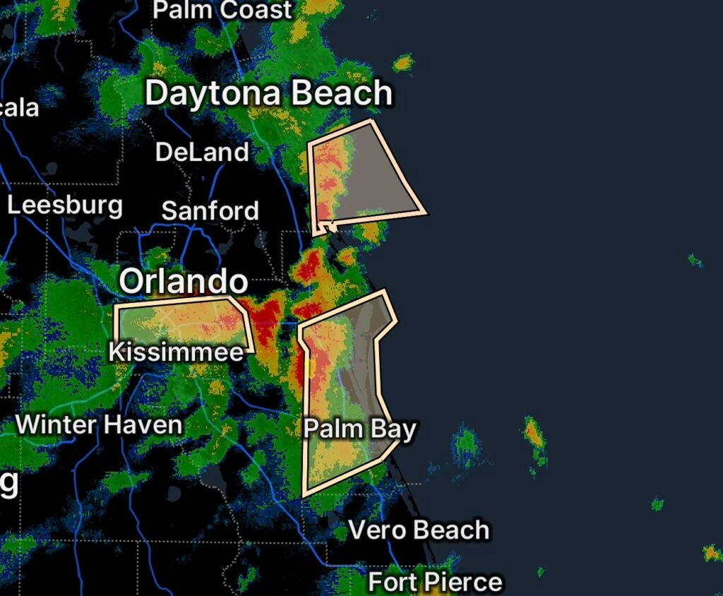
Strong thunderstorms are impacting portions of Florida’s Space Coast this afternoon, creating hazards both on land and over nearby Atlantic waters. The National Weather Service in Melbourne issued a Marine Weather Statement for waters from Flagler Beach south toward the Volusia-Brevard County line and a Special Weather Statement for communities including Palm Bay, Melbourne, Rockledge, Cocoa, and Cocoa Beach. (National Weather Service)
Marine Weather Statement: Coastal Waters Face Storm Hazards
The marine weather statement covers the Volusia-Brevard County Line to Sebastian Inlet, 0–20 nautical miles offshore, among nearby marine zones.
Thunderstorms moving across the Space Coast are capable of producing wind gusts up to 40 knots, along with sudden higher waves, frequent lightning, and heavy downpours. (National Weather Service)
For boaters, these conditions can develop quickly. A relatively calm stretch of water can become hazardous as thunderstorms approach, particularly when strong outflow winds reach the coast.
Boaters Should Seek Safe Harbor
Anyone already on the water should closely monitor weather conditions and be prepared to return to shore.
The National Weather Service warns that thunderstorms can produce:
- Wind gusts exceeding 34 knots
- Sudden increases in wave heights
- Frequent cloud-to-water lightning
- Heavy rainfall and reduced visibility
- Potential waterspouts
Waterspouts can pose a serious threat to smaller vessels and may overturn boats. Boaters should seek safe harbor when storms approach and ensure everyone aboard is wearing a life jacket. (National Weather Service)
Special Weather Statement for Brevard County
At the same time, strong thunderstorms were moving across Brevard County.
According to the National Weather Service, radar showed a line of thunderstorms extending from Sharpes to west of Viera and toward Palm Bay, moving northeast at approximately 25 mph. The storms were capable of producing wind gusts up to 50 mph. (National Weather Service)
Communities in the Storm’s Path
The Special Weather Statement specifically included:
- Palm Bay
- Melbourne
- Rockledge
- Cocoa
- Cocoa Beach
Gusty winds could break tree limbs and blow unsecured outdoor objects around. Frequent cloud-to-ground lightning was also occurring with the storms. (National Weather Service)
Why These Storms Can Strengthen Quickly
Late-summer thunderstorms across Central Florida can intensify rapidly when warm, humid air combines with daytime heating and available atmospheric instability.
As storms develop, strong downdrafts can push air toward the surface and create powerful outflow winds. These winds can spread away from the storm and produce sudden gusts well away from the heaviest rainfall.
Meanwhile, intense rainfall can temporarily reduce visibility and create ponding on roads, especially in areas with poor drainage.
Lightning Remains a Major Threat
Lightning is one of the most dangerous aspects of these storms.
A thunderstorm does not need to be directly overhead for lightning to become a threat. The National Weather Service notes that lightning can strike more than 10 miles from a thunderstorm. (National Weather Service)
If you hear thunder, move indoors. Beaches, docks, boats, parks, athletic fields, and other exposed locations are particularly dangerous during thunderstorms.
Safety Tips for the Space Coast
If You Are Outdoors
Move inside a sturdy building or hard-topped vehicle as soon as thunder is heard. Avoid beaches, open fields, elevated locations, and isolated trees.
If You Are Driving
Slow down when heavy rain reduces visibility. Watch for standing water and avoid driving through flooded roadways.
If You Are Boating
Get to safe harbor before storms arrive whenever possible. If caught on the water, everyone should wear a life jacket and remain alert for lightning, sudden wind shifts, heavy rain, and rapidly building waves.
Radar Watch HQ Final Thoughts
The combination of strong thunderstorms, gusty winds, lightning, heavy rainfall, and marine hazards makes this an active weather period for Florida’s Space Coast this afternoon.
Residents from Palm Bay through Melbourne, Rockledge, Cocoa, and Cocoa Beach should remain weather-aware, while boaters offshore should take thunderstorms seriously and move toward safe harbor when storms approach.
Conditions can change quickly during Florida’s summer thunderstorm season. Continue monitoring updated weather information and be prepared to act if a stronger warning is issued.
Stay weather-aware, stay prepared, and stay safe.

Radar Watch HQ Top 5 Marine Essentials
Affiliate Disclosure: As an Amazon Associate, Radar Watch HQ earns from qualifying purchases.
🌊 1. U.S. Coast Guard-Approved Life Jacket
A properly fitted life jacket is the most important piece of safety equipment for every passenger onboard.
Best for: Recreational boaters, anglers, kayakers, and paddleboarders.
⚓ 2. Marine Emergency Radio (NOAA Weather Radio)
Receive real-time NOAA Weather Radio alerts, marine forecasts, and emergency warnings—even when cell service is unavailable.
Best for: Offshore and coastal boating.
🔦 3. Rechargeable Waterproof LED Flashlight
A bright waterproof flashlight is essential for emergencies, low visibility, nighttime navigation, and signaling for help.
Best for: Every boat emergency kit.
🧰 4. Marine First Aid Kit
A waterproof first aid kit stocked with bandages, antiseptic, medications, and emergency supplies for injuries on the water.
Best for: Every vessel, regardless of size.
🧭 5. Waterproof Dry Bag
Protect phones, wallets, charts, keys, electronics, and emergency supplies from water damage during storms or rough seas.
Best for: Boaters, kayakers, paddleboarders, and beachgoers.
🛒 Radar Watch HQ Marine Safety Picks
Prepare before you head out on the water. Our recommended marine safety essentials can help keep you and your crew safe during changing weather conditions.