Severe Thunderstorm Warning and Strong Storms Threaten South Central Texas
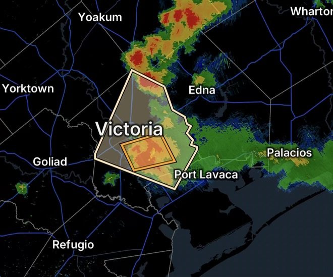
A Severe Thunderstorm Warning for Central Victoria County in south central Texas is highlighting an active period of thunderstorms across the region on Friday, August 28. At the same time, a Special Weather Statement for Inland Calhoun County and Victoria County warns of strong thunderstorms capable of producing gusty winds and hail.
The developing storms come as hot and humid conditions remain in place across South Texas. The National Weather Service forecast for Victoria calls for temperatures near 98°F, with heat index values potentially reaching around 110°F, while thunderstorms are possible during the afternoon. (National Weather Service)
Severe Thunderstorm Warning for Central Victoria County
Residents in Central Victoria County should take the Severe Thunderstorm Warning seriously and move indoors when storms approach.
Severe thunderstorms can quickly intensify, producing:
- Damaging wind gusts
- Hail
- Frequent lightning
- Torrential rainfall
- Brief reductions in visibility
- Dangerous driving conditions
- Isolated power outages
- Downed tree limbs and other debris
Even when a storm is not producing a tornado, severe thunderstorm winds can cause significant damage. The National Weather Service recommends moving into an interior room on the lowest floor of a sturdy building when severe weather threatens. (National Weather Service)
Why These Storms Can Become Strong
South Texas remains extremely warm and humid, providing thunderstorms with substantial atmospheric energy. When hot, moisture-rich air combines with a developing storm, strong updrafts can allow thunderstorms to intensify rapidly.
That environment can support stronger downdrafts and damaging wind gusts as thunderstorms collapse or develop into more organized storm clusters.
Additionally, heavy rain falling from thunderstorms can quickly overwhelm poor-drainage areas, especially where storms repeatedly move over the same locations.
Special Weather Statement: Calhoun and Victoria Counties
A Special Weather Statement is also in effect for portions of Inland Calhoun County and Victoria County because of strong thunderstorms.
The latest available alert information indicates that thunderstorms in the area could produce wind gusts up to 50 mph and penny-size hail. (Weather Underground)
Strong thunderstorms can still create hazardous conditions even when they do not meet the criteria for a Severe Thunderstorm Warning.
Residents should remain weather-aware because a Special Weather Statement can precede an upgrade to a more serious warning if storms strengthen.
Communities to Watch
The greatest concern is across Central Victoria County, with additional attention needed across Victoria County and Inland Calhoun County.
Areas around Victoria and surrounding communities should be prepared for rapidly changing weather conditions, particularly when thunderstorms approach.
Motorists traveling through the region should also be prepared for sudden heavy rain, lightning and strong wind gusts.
What Residents Should Do Now
1. Get Indoors When Thunder Roars
If you can hear thunder, lightning is close enough to pose a danger.
Move inside a sturdy building and remain there until the storm has passed.
2. Protect Yourself From Hail and Wind
Stay away from windows and glass doors. If severe winds or hail become intense, move to an interior room on the lowest floor.
Secure or bring inside lightweight outdoor objects that could become airborne.
3. Avoid Flooded Roads
Heavy thunderstorms can produce sudden water accumulation on roads and in low-lying areas.
Never drive through a flooded roadway. Water depth and current strength can be difficult to judge, and road conditions can deteriorate rapidly.
4. Stay Away From Trees During Lightning
A thunderstorm is not a safe time to remain underneath trees, near open fields or beside isolated tall objects.
If you are outside when lightning approaches, get inside a substantial building or enclosed vehicle as quickly as possible.
Heat and Storms Create an Additional Hazard
The combination of extreme summer heat and thunderstorms makes conditions particularly challenging across South Texas.
Victoria’s forecast calls for a high near 98°F, with heat index values potentially reaching 110°F. (National Weather Service)
Because of the heat, people working outdoors or attending outdoor activities should monitor both the temperature and approaching thunderstorms.
A storm can bring temporary relief from the heat, but lightning, strong winds and heavy rainfall can create a separate set of hazards.
Radar Watch HQ Weather Outlook
The threat will not necessarily end with one thunderstorm.
Thunderstorms can strengthen or weaken rapidly, and conditions can change considerably over a short distance. Residents across Victoria and Calhoun counties should continue monitoring updated weather information throughout the afternoon and evening.
The broader forecast for Victoria indicates additional chances for thunderstorms, although hot and mostly sunny conditions remain dominant outside of storm activity. (National Weather Service)
Stay Weather Ready
Keep your phone charged, enable emergency weather alerts and have a safe indoor location identified before storms arrive.
If a Severe Thunderstorm Warning is issued for your location, do not wait to see the storm before taking action.
Radar Watch HQ Final Thoughts
A Severe Thunderstorm Warning for Central Victoria County combined with a Special Weather Statement covering portions of Inland Calhoun County and Victoria County means residents across the region should remain alert for rapidly changing conditions.
The primary concerns include damaging wind gusts, hail, lightning, heavy rainfall and dangerous travel conditions.
Storms may be localized, but their impacts can be significant. Staying informed and moving indoors early are two of the most effective ways to reduce your risk.
Stay weather-aware, monitor official alerts and keep Radar Watch HQ on your radar for continuing severe weather coverage across Texas and the nation.

Affiliate Disclosure: As an Amazon Associate, Radar Watch HQ earns from qualifying purchases.
Radar Watch HQ Top 5 Essential Emergency Preparedness Picks
Whether you’re preparing for severe thunderstorms, flash flooding, hurricanes, wildfires, or extended power outages, these five emergency essentials can help keep your household safer when severe weather strikes.
A portable power station provides reliable backup electricity during outages, allowing you to power phones, medical devices, laptops, lights, small appliances, and communication equipment without fuel.
Best for:
- Extended power outages
- Severe thunderstorms
- Hurricanes
- Winter storms
- Wildfires
2. Flood Protection Barriers & Sandless Flood Bags
Flood barriers help divert or absorb water before it enters garages, doorways, and low-lying areas. They deploy quickly and can help reduce property damage during flash flooding.
Best for:
- Flash Flood Warnings
- Heavy rainfall
- River flooding
- Coastal flooding
3. Rechargeable LED Flashlights
Bright, dependable flashlights are essential when the power goes out. Rechargeable or solar-powered models provide long-lasting illumination for navigating safely indoors and outdoors.
Best for:
- Overnight power outages
- Emergency evacuations
- Storm damage inspections
Keep phones, tablets, weather radios, and USB-powered devices charged when the electrical grid is unavailable. A solar power bank offers an additional charging option during prolonged emergencies.
Best for:
- Communication during outages
- Emergency weather alerts
- Travel and evacuation
A NOAA Weather Radio delivers official weather alerts directly from the National Weather Service, even when cellular networks or internet service are unavailable. It remains one of the most dependable ways to receive life-saving warnings.
Best for:
- Tornado warnings
- Severe thunderstorm warnings
- Flash flood warnings
- Hurricane alerts
- Winter storm emergencies
Why Radar Watch HQ Recommends These Essentials
At Radar Watch HQ, preparedness is just as important as staying informed. These five emergency essentials can help you stay connected, protect your property, and safely navigate severe weather events. Having supplies ready before storms arrive allows you to respond quickly when warnings are issued and conditions begin to deteriorate.