
















Tropical Depression Edouard Floods Southeast Texas
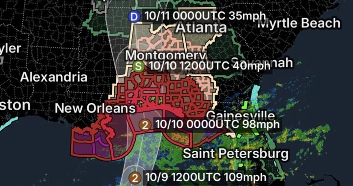
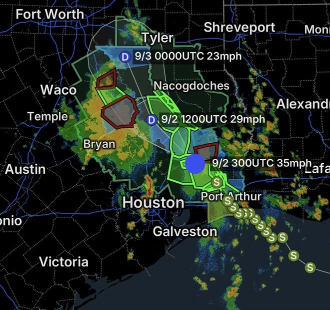
Tropical Depression Edouard continues to leave a significant weather footprint across Southeast Texas, where torrential rainfall, dangerous flooding, blocked roads, and widespread power outages have created hazardous conditions. The former Tropical Storm Edouard weakened after making landfall near the Texas-Louisiana border, but its circulation continued producing heavy rainfall inland.
Some locations in Southeast Texas have received more than 20 inches of rainfall, with especially serious flooding reported across Hardin and Tyler counties.
Flood Watch Continues Across Southeast Texas
A Flood Watch covers portions of Southeast Texas, including:
- Hardin County
- Lower Jefferson County
- Northern Orange County
- Southern Jasper County
- Southern Newton County
- Southern Orange County
- Tyler County
- Upper Jefferson County
These areas remain vulnerable because soils are heavily saturated and additional rainfall can rapidly increase water levels in creeks, rivers, drainage channels, and low-lying neighborhoods.
The National Weather Service’s Weather Prediction Center warned that additional very heavy rainfall associated with Edouard could produce major flooding across areas that had already experienced torrential rainfall.
Flood Warnings Highlight Life-Threatening Conditions
Flood Warnings are in effect for portions of:
Hardin County
Hardin County has been among the hardest-hit areas. Extremely heavy rainfall has produced dangerous flooding, flooded roadways, downed trees, and significant infrastructure problems.
Rainfall totals in parts of the county have exceeded 15 to 20 inches, with some reports substantially higher.
Northwestern Jefferson County
Flooding is also affecting northwestern Jefferson County, where heavy rainfall and runoff have created dangerous travel conditions.
Residents should avoid attempting to drive through flooded roads, especially where water is moving across the roadway.
South-Central Tyler County
South-central Tyler County has experienced some of the most extreme rainfall associated with Edouard. Flooding has affected roads, homes, and other infrastructure, while emergency responders have faced difficult conditions.
Hardin County Power Outages Add Another Threat
Power outages are another major concern across Hardin County and surrounding Southeast Texas communities.
Edouard produced strong winds capable of bringing down trees and power lines. Flooded and blocked roads are also making it more difficult for utility crews to reach damaged infrastructure.
Across the broader Entergy Texas service area, tens of thousands of customers remained without electricity after the storm, with Hardin, Jefferson, and Orange counties among the areas experiencing significant impacts.
Residents without electricity should treat every downed power line as energized and extremely dangerous. Stay far away and report it to the appropriate utility or emergency authorities.
Why Edouard Produced So Much Rain
Tropical systems can remain extremely efficient rainfall producers even after weakening below tropical-storm strength.
Edouard carried abundant tropical moisture inland. As the circulation interacted with the atmosphere over East Texas, bands of thunderstorms repeatedly moved across the same locations.
That process, sometimes called training, can result in rainfall accumulating much faster than the ground and drainage systems can handle.
The result has been an especially dangerous combination:
- Extremely heavy rainfall
- Saturated soils
- Rapid creek and river rises
- Flash flooding
- Flooded roadways
- Downed trees and power lines
- Extended power outages
The Weather Prediction Center specifically warned that heavy rainfall would continue affecting east-central Texas while major flooding remained possible in areas that had already received excessive rain.
Travel Conditions Remain Dangerous
Flooded roads remain one of the greatest immediate threats.
Never drive through floodwater. Water can hide washed-out pavement, debris, damaged bridges, and deep channels. Even relatively shallow moving water can push a vehicle off the roadway.
If a road is barricaded, turn around and find another route.
Emergency responders across Texas have already conducted rescues involving people stranded in vehicles and homes surrounded by floodwater.
What Southeast Texas Residents Should Do Now
If you are in or near the Flood Watch or Flood Warning areas:
- Monitor weather and emergency alerts closely.
- Move to higher ground if flooding begins approaching your location.
- Never drive across a flooded roadway.
- Stay away from rivers, creeks, bayous, and drainage channels.
- Avoid downed power lines and damaged utility equipment.
- Use flashlights rather than candles during power outages.
- Keep phones and emergency batteries charged whenever possible.
- Follow evacuation instructions from local officials immediately.
Remember: Turn Around, Don’t Drown.
Tropical Depression Edouard Recovery Will Take Time
Although Edouard has weakened considerably, the danger does not immediately disappear when a tropical system loses its tropical-storm classification.
Floodwaters can continue rising after the heaviest rain has ended, while swollen rivers and creeks may remain dangerous for hours or days. Meanwhile, saturated ground, damaged roads, downed trees, and electrical infrastructure can complicate recovery.
For Southeast Texas, particularly Hardin, Jefferson, Orange, Jasper, Newton, and Tyler counties, the focus is now shifting from the storm’s winds to flooding, power restoration, infrastructure damage, and recovery.
Radar Watch HQ Final Thoughts
Tropical Depression Edouard is a reminder that a weakening tropical system can still produce dangerous and potentially life-threatening flooding well inland.
For Southeast Texas, the combination of extraordinary rainfall, saturated ground, flooded roads, and power outages makes continued vigilance essential.
If you are under a Flood Warning, take it seriously. Move away from rising water, stay off flooded roads, and give emergency crews and utility workers room to operate.
Radar Watch HQ will continue monitoring the evolving flood and recovery situation across Southeast Texas. Stay weather-aware, stay prepared, and put safety first.

Affiliate Disclosure: As an Amazon Associate, Radar Watch HQ earns from qualifying purchases.
Radar Watch HQ Top 5 Essential Emergency Preparedness Picks
Whether you’re preparing for severe thunderstorms, flash flooding, hurricanes, wildfires, or extended power outages, these five emergency essentials can help keep your household safer when severe weather strikes.
A portable power station provides reliable backup electricity during outages, allowing you to power phones, medical devices, laptops, lights, small appliances, and communication equipment without fuel.
Best for:
- Extended power outages
- Severe thunderstorms
- Hurricanes
- Winter storms
- Wildfires
2. Flood Protection Barriers & Sandless Flood Bags
Flood barriers help divert or absorb water before it enters garages, doorways, and low-lying areas. They deploy quickly and can help reduce property damage during flash flooding.
Best for:
- Flash Flood Warnings
- Heavy rainfall
- River flooding
- Coastal flooding
3. Rechargeable LED Flashlights
Bright, dependable flashlights are essential when the power goes out. Rechargeable or solar-powered models provide long-lasting illumination for navigating safely indoors and outdoors.
Best for:
- Overnight power outages
- Emergency evacuations
- Storm damage inspections
Keep phones, tablets, weather radios, and USB-powered devices charged when the electrical grid is unavailable. A solar power bank offers an additional charging option during prolonged emergencies.
Best for:
- Communication during outages
- Emergency weather alerts
- Travel and evacuation
A NOAA Weather Radio delivers official weather alerts directly from the National Weather Service, even when cellular networks or internet service are unavailable. It remains one of the most dependable ways to receive life-saving warnings.
Best for:
- Tornado warnings
- Severe thunderstorm warnings
- Flash flood warnings
- Hurricane alerts
- Winter storm emergencies
Why Radar Watch HQ Recommends These Essentials
At Radar Watch HQ, preparedness is just as important as staying informed. These five emergency essentials can help you stay connected, protect your property, and safely navigate severe weather events. Having supplies ready before storms arrive allows you to respond quickly when warnings are issued and conditions begin to deteriorate.