Severe Thunderstorms & Outages in Montana
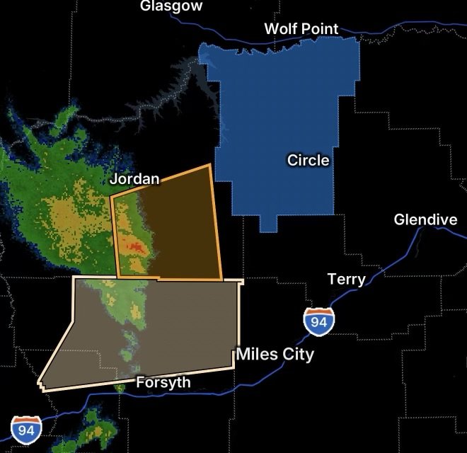
A round of active thunderstorms is bringing heightened weather concerns across eastern Montana. Radar Watch HQ is tracking a Severe Thunderstorm Warning for southeastern Garfield County, a Special Weather Statement covering Northern Treasure and Northern Rosebud counties, and reported power outage concerns in McCone County.
Residents across the region should remain weather-aware as thunderstorms can intensify quickly, producing damaging wind gusts, hail, frequent lightning and locally heavy rainfall.
Severe Thunderstorm Warning: Southeastern Garfield County
The National Weather Service has previously issued severe thunderstorm warnings for southeastern Garfield County, with storms capable of producing 60 mph wind gusts and nickel-size hail. Areas including Jordan and Cohagen have been impacted by severe thunderstorms.
Severe thunderstorms can produce rapidly changing conditions, particularly across rural areas where reaching shelter may take additional time.
Main threats
The primary concerns with severe thunderstorms include:
- Damaging wind gusts
- Large or damaging hail
- Frequent cloud-to-ground lightning
- Heavy rainfall
- Reduced visibility
- Downed trees and power lines
- Potential power interruptions
If a Severe Thunderstorm Warning is active for your location, move indoors immediately. Stay away from windows and use an interior room when possible.
Special Weather Statement: Northern Treasure and Northern Rosebud Counties
Northern Treasure and Northern Rosebud counties are also areas to monitor as strong thunderstorms move through southeastern Montana.
A Special Weather Statement is generally issued when storms are producing or could produce hazardous conditions that may not meet the threshold for a Severe Thunderstorm Warning. However, these storms can still create dangerous lightning, gusty winds, heavy rain and rapidly changing travel conditions.
Previous National Weather Service information for the region has documented strong storms capable of producing damaging wind and hail, including activity affecting northern Rosebud and northwestern Treasure counties.
Don’t underestimate lightning
Even when a storm is not classified as severe, lightning remains a significant danger.
If you can hear thunder, you are close enough to be struck by lightning.
Outdoor activities should be postponed until the storm has moved away and conditions have safely improved.
McCone County Power Outage Concerns
Power outages are another concern as thunderstorms affect eastern Montana.
McCone County has experienced significant weather-related power impacts during previous severe weather events, including damage involving electrical infrastructure across eastern Montana.
Strong thunderstorm winds can bring down tree limbs and power lines, while lightning can cause additional disruptions.
Residents experiencing an outage should:
- Report the outage to their electric provider.
- Stay away from downed power lines.
- Treat every downed line as energized.
- Keep refrigerators and freezers closed as much as possible.
- Use flashlights instead of candles.
- Unplug sensitive electronics if conditions allow.
- Check on neighbors who may need assistance.
Why Eastern Montana Can See Rapidly Changing Storms
Thunderstorms develop when warm, moist air becomes unstable and rising air interacts with atmospheric forcing. When sufficient instability and wind shear are present, storms can strengthen rapidly.
In eastern Montana, widely spaced communities and long stretches of rural roadway can make storm preparedness particularly important. A storm that appears distant can move into an area quickly, especially when traveling at highway speeds.
Additionally, strong outflow winds can spread well beyond the heaviest rainfall core.
Travel Safety During Thunderstorms
Motorists across Garfield County, Treasure County, Rosebud County and McCone County should be prepared for sudden reductions in visibility, heavy rainfall, hail and strong crosswinds.
If hail begins falling, slow down and find a safe location to stop whenever possible. Avoid stopping beneath trees or utility lines.
Never drive through water covering a roadway. Even relatively shallow moving water can sweep a vehicle off the road.
What Residents Should Do Now
Weather conditions can evolve quickly, so residents should keep phones charged and have multiple ways to receive weather information.
Keep a flashlight, extra batteries, medications, essential supplies and backup power available, particularly if your area is experiencing an outage.
Most importantly, take a Severe Thunderstorm Warning seriously. You do not need to wait for visible damage or a tornado before seeking shelter.
Radar Watch HQ Final Thoughts
Eastern Montana is dealing with a combination of strong thunderstorms, severe-weather potential and power concerns. Southeastern Garfield County should take any active Severe Thunderstorm Warning seriously, while residents across Northern Treasure and Northern Rosebud counties should continue monitoring storms covered by the Special Weather Statement.
Meanwhile, McCone County residents affected by power outages should stay away from downed lines and prepare for the possibility of extended disruptions.
Stay weather-aware, stay indoors when storms approach, and continue monitoring official weather and local emergency information throughout the day.
Affiliate Disclosure: As an Amazon Associate, Radar Watch HQ earns from qualifying purchases.
Radar Watch HQ Top 5 Essential Emergency Preparedness Picks
Whether you’re preparing for severe thunderstorms, flash flooding, hurricanes, wildfires, or extended power outages, these five emergency essentials can help keep your household safer when severe weather strikes.
A portable power station provides reliable backup electricity during outages, allowing you to power phones, medical devices, laptops, lights, small appliances, and communication equipment without fuel.
Best for:
- Extended power outages
- Severe thunderstorms
- Hurricanes
- Winter storms
- Wildfires
2. Flood Protection Barriers & Sandless Flood Bags
Flood barriers help divert or absorb water before it enters garages, doorways, and low-lying areas. They deploy quickly and can help reduce property damage during flash flooding.
Best for:
- Flash Flood Warnings
- Heavy rainfall
- River flooding
- Coastal flooding
3. Rechargeable LED Flashlights
Bright, dependable flashlights are essential when the power goes out. Rechargeable or solar-powered models provide long-lasting illumination for navigating safely indoors and outdoors.
Best for:
- Overnight power outages
- Emergency evacuations
- Storm damage inspections
Keep phones, tablets, weather radios, and USB-powered devices charged when the electrical grid is unavailable. A solar power bank offers an additional charging option during prolonged emergencies.
Best for:
- Communication during outages
- Emergency weather alerts
- Travel and evacuation
A NOAA Weather Radio delivers official weather alerts directly from the National Weather Service, even when cellular networks or internet service are unavailable. It remains one of the most dependable ways to receive life-saving warnings.
Best for:
- Tornado warnings
- Severe thunderstorm warnings
- Flash flood warnings
- Hurricane alerts
- Winter storm emergencies
Why Radar Watch HQ Recommends These Essentials
At Radar Watch HQ, preparedness is just as important as staying informed. These five emergency essentials can help you stay connected, protect your property, and safely navigate severe weather events. Having supplies ready before storms arrive allows you to respond quickly when warnings are issued and conditions begin to deteriorate.