Flash Flood Warning and Severe Storms Develop Across the Region
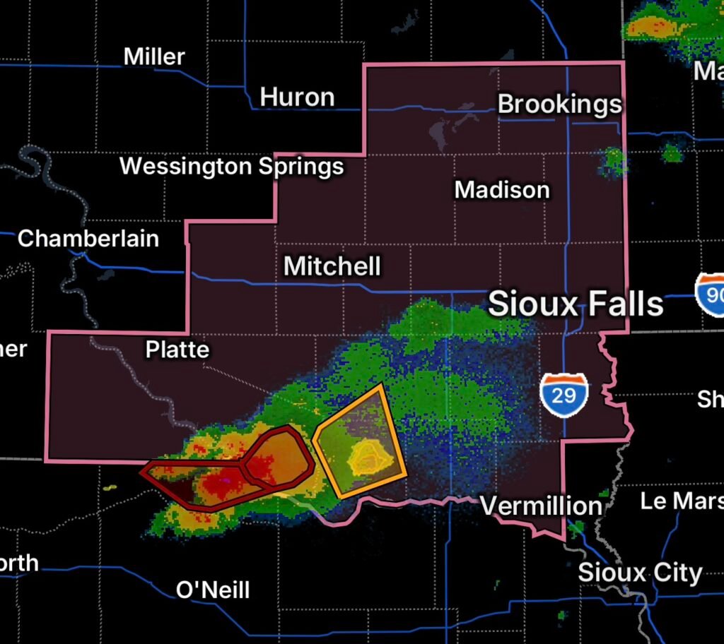
A dangerous combination of flash flooding and severe thunderstorms is unfolding across portions of southeast South Dakota and north central Nebraska this evening. The latest weather situation includes a Flash Flood Warning for southeastern Charles Mix County, a Severe Thunderstorm Watch covering portions of southeast South Dakota, a Flash Flood Warning for eastern Boyd County, Nebraska, and a Severe Thunderstorm Warning affecting northeastern Bon Homme and south central Hutchinson County.
The National Weather Service has highlighted the potential for additional strong to severe thunderstorms across southeast South Dakota tonight, with large hail, damaging wind gusts and locally heavy rainfall among the primary concerns.
For residents in the affected areas, conditions can change rapidly as thunderstorms move through.
Flash Flood Warning for Southeastern Charles Mix County
A Flash Flood Warning is in effect for southeastern Charles Mix County as thunderstorms produce intense rainfall.
Heavy thunderstorms can overwhelm drainage systems, cause rapid rises in smaller streams and creeks, and create dangerous water-covered roadways.
Even if rainfall appears to have stopped at your location, flooding can continue downstream or in low-lying areas.
Flash Flood Safety
If you encounter water covering a roadway:
Turn around. Don’t drown.
Never drive through a flooded roadway when the depth or condition of the road cannot be determined. Moving water can conceal washed-out pavement, debris or damaged bridges.
Residents in flood-prone areas should also be prepared to move to higher ground if water begins rising quickly.
Severe Thunderstorm Watch Covers Portions of Southeast South Dakota
A Severe Thunderstorm Watch remains an important concern across portions of southeast South Dakota. The latest watch information includes Bon Homme, Charles Mix, Hutchinson and surrounding counties.
The National Weather Service forecast indicates that additional strong to severe storms could occur during the evening and overnight hours. Potential hazards include:
- Large hail
- Damaging wind gusts
- Torrential rainfall
- Frequent lightning
- Isolated tornado potential
The greatest concern is that storms may produce both severe weather and flooding simultaneously.
That combination can make nighttime travel particularly dangerous.
Severe Thunderstorm Warning for Bon Homme and Hutchinson Counties
A Severe Thunderstorm Warning is affecting northeastern Bon Homme County and south central Hutchinson County.
Residents within the warned area should move indoors and remain away from windows while the storm passes.
The National Weather Service has previously documented severe thunderstorms in this area producing large hail and damaging winds, demonstrating the potential for rapidly developing severe conditions across the region.
What to Do During a Severe Thunderstorm
When a severe thunderstorm warning is issued:
- Go inside a sturdy building immediately.
- Move to an interior room away from windows.
- Stay on the lowest floor when possible.
- Avoid unnecessary travel.
- Bring pets indoors.
- Stay away from trees and isolated structures.
- Monitor weather updates until the threat has passed.
If a tornado warning is issued, immediately move to a small interior room on the lowest floor and protect your head and neck.
Flash Flood Warning for Eastern Boyd County, Nebraska
A separate Flash Flood Warning is in effect for eastern Boyd County in north central Nebraska.
According to the National Weather Service, thunderstorms were producing heavy rainfall across the warned area, with 1 to 3 inches of rain already reported and additional rainfall possible.
That amount of rainfall over a short period can quickly overwhelm local drainage and produce dangerous flash flooding.
The threat is especially serious near:
- Creeks and streams
- Low-water crossings
- Rural roads
- Ditches and drainage channels
- Low-lying farmland
- Areas that have already received heavy rain
Flooding Can Continue After the Storm
One of the most important things to remember is that the heaviest rainfall does not necessarily mean the immediate end of the flooding threat.
Water can continue flowing into low-lying locations after a thunderstorm moves away. Roads that appear passable can also become dangerous within minutes.
Never walk or drive through moving floodwater.
Why These Storms Can Produce Heavy Rain
Thunderstorms become particularly dangerous when they repeatedly move across the same areas or develop within a moisture-rich environment.
Strong thunderstorms can release large amounts of rain in a short period. When rainfall exceeds the ability of soil, drainage systems and waterways to absorb or carry the water away, flooding can develop rapidly.
At the same time, strong atmospheric instability can support large hail and damaging wind gusts.
The result is a multi-hazard weather event, where residents may need to prepare for flooding and severe thunderstorms at the same time.
What Residents Should Watch Tonight
The weather threat does not necessarily end when one warning expires.
Additional thunderstorms could develop or move into the region during the evening and overnight hours. The National Weather Service’s outlook calls for strong to severe storms across portions of southeast South Dakota, with large hail, damaging winds and locally heavy rainfall possible.
Residents should continue monitoring:
- Flash Flood Warnings
- Severe Thunderstorm Warnings
- Tornado Warnings
- Additional Severe Thunderstorm Watches
- Rapidly rising water
- Road closures
- Local emergency information
Radar Watch HQ Final Thoughts
Tonight’s weather situation across southeast South Dakota and north central Nebraska is a reminder that severe weather does not always arrive as a single hazard.
Flash flooding, large hail, damaging winds and thunderstorms can occur together.
If you are under a warning, take action immediately rather than waiting for conditions to deteriorate. Most importantly, never attempt to cross flooded roads or moving water.
Stay weather-aware, stay indoors during severe thunderstorms, and keep monitoring official weather information throughout the night.
Affiliate Disclosure: As an Amazon Associate, Radar Watch HQ earns from qualifying purchases.
Radar Watch HQ Top 5 Essential Emergency Preparedness Picks
Whether you’re preparing for severe thunderstorms, flash flooding, hurricanes, wildfires, or extended power outages, these five emergency essentials can help keep your household safer when severe weather strikes.
A portable power station provides reliable backup electricity during outages, allowing you to power phones, medical devices, laptops, lights, small appliances, and communication equipment without fuel.
Best for:
- Extended power outages
- Severe thunderstorms
- Hurricanes
- Winter storms
- Wildfires
2. Flood Protection Barriers & Sandless Flood Bags
Flood barriers help divert or absorb water before it enters garages, doorways, and low-lying areas. They deploy quickly and can help reduce property damage during flash flooding.
Best for:
- Flash Flood Warnings
- Heavy rainfall
- River flooding
- Coastal flooding
3. Rechargeable LED Flashlights
Bright, dependable flashlights are essential when the power goes out. Rechargeable or solar-powered models provide long-lasting illumination for navigating safely indoors and outdoors.
Best for:
- Overnight power outages
- Emergency evacuations
- Storm damage inspections
Keep phones, tablets, weather radios, and USB-powered devices charged when the electrical grid is unavailable. A solar power bank offers an additional charging option during prolonged emergencies.
Best for:
- Communication during outages
- Emergency weather alerts
- Travel and evacuation
A NOAA Weather Radio delivers official weather alerts directly from the National Weather Service, even when cellular networks or internet service are unavailable. It remains one of the most dependable ways to receive life-saving warnings.
Best for:
- Tornado warnings
- Severe thunderstorm warnings
- Flash flood warnings
- Hurricane alerts
- Winter storm emergencies
Why Radar Watch HQ Recommends These Essentials
At Radar Watch HQ, preparedness is just as important as staying informed. These five emergency essentials can help you stay connected, protect your property, and safely navigate severe weather events. Having supplies ready before storms arrive allows you to respond quickly when warnings are issued and conditions begin to deteriorate.