Tropical Storm Norbert Forms Well Southwest of Baja California as Another Area of Development Emerges
Tropical Storm Norbert has formed in the eastern Pacific, becoming the latest named system to develop well southwest of the southern tip of the Baja California Peninsula.
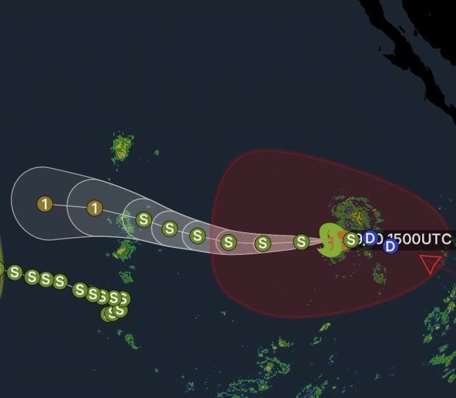
As of the latest National Hurricane Center information, Norbert is located several hundred miles southwest of the southern tip of Baja California and is moving generally westward to west-northwestward over the open Pacific. The storm remains far from land, and there are currently no coastal watches or warnings associated with Norbert. (National Hurricane Center)
Norbert’s Current Position and Movement
Norbert developed from an area of low pressure that became increasingly organized as showers and thunderstorms concentrated around the circulation.
The National Hurricane Center initially identified the system as Tropical Depression Fourteen-E before strengthening was expected. By Thursday, the system had developed into Tropical Storm Norbert. (National Hurricane Center)
The system is traveling generally westward across the East Pacific. Because Norbert is remaining over open water and away from populated coastal areas, there are no immediate land impacts being reported from the storm.
The storm’s track will remain important to monitor, however, because tropical cyclones can change strength and organization as environmental conditions evolve.
A Tropical System in the Central and Western East Pacific
Norbert is part of an active stretch of tropical weather across the Pacific.
The broader tropical environment across the central and western portions of the East Pacific has featured areas of showers and thunderstorms capable of organizing into tropical systems. The National Hurricane Center has also highlighted another area of low pressure expected to develop several hundred miles south of the southern tip of Baja California this weekend or early next week. (National Hurricane Center)
That additional disturbance could gradually organize while moving generally westward, with the potential for a tropical depression to form early next week.
This means the East Pacific will continue to require close monitoring even as Norbert moves farther away from Baja California.
Why Norbert Matters
Tropical systems over the open Pacific can remain significant weather features even when they are not threatening land.
Norbert’s development demonstrates how clusters of thunderstorms and broad areas of low pressure can gradually organize over warm tropical waters. When thunderstorms become more concentrated around a developing circulation, the system can transition from a disturbance to a tropical depression and eventually a tropical storm.
The atmosphere surrounding a tropical cyclone—including ocean temperatures, wind shear, moisture, and surrounding weather patterns—plays an important role in determining whether a storm strengthens or weakens.
No Immediate Coastal Threat
At this time, Norbert is located well offshore, and the National Hurricane Center reports no coastal watches or warnings associated with the system. (National Hurricane Center)
Residents and visitors along the Baja California Peninsula should continue relying on official forecasts for any changes, but there is no indication from the current information that Norbert poses an immediate direct threat to the coast.
Marine interests, however, should continue monitoring official forecasts because tropical systems can produce rough seas, stronger winds, and hazardous conditions well away from the center.
What to Watch Next
The primary focus over the coming days will be Norbert’s strength and westward movement across the Pacific.
Forecasters will also be watching the additional area of low pressure expected to develop farther east near the southern tip of Baja California. The National Hurricane Center has given that system a medium chance of tropical cyclone formation over the seven-day period. (National Hurricane Center)
For now, Norbert remains an open-ocean tropical cyclone with no immediate land threat. Conditions can change quickly during hurricane season, making continued monitoring of official National Hurricane Center updates important.
Radar Watch HQ will continue tracking the latest developments across the Pacific and breaking down what they could mean for communities, travelers, and marine interests.
Stay weather-aware, monitor official forecasts, and keep checking back with Radar Watch HQ for the latest tropical weather updates.