Southwest Florida Faces Multiple Weather Concerns
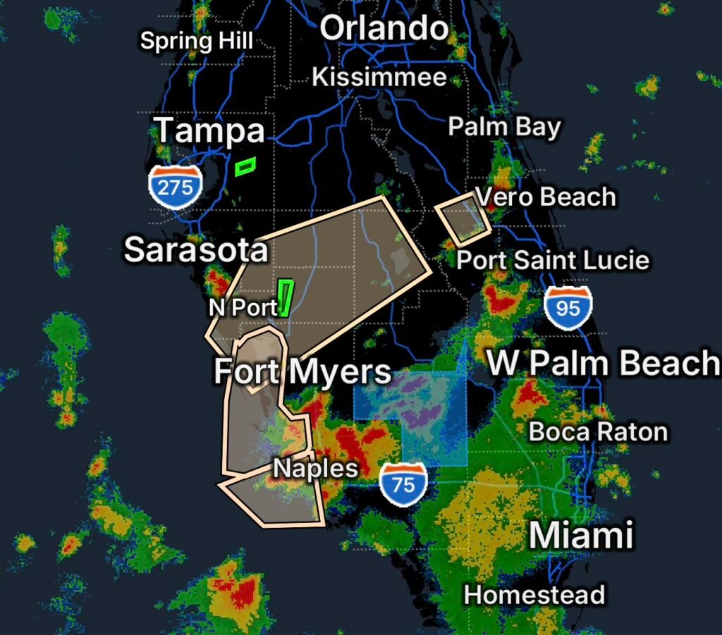
Residents across portions of Southwest Florida are being urged to stay weather-aware Thursday as several weather-related statements and a Flood Warning affect communities across the region.
The National Weather Service uses Special Weather Statements and Marine Weather Statements to communicate weather conditions that may require increased awareness even when a higher-level warning or advisory is not in effect.
The combination of potentially active thunderstorms, heavy rainfall, rising water levels and marine hazards means conditions can change quickly, particularly near waterways and coastal areas.
Special Weather Statement for Fort Drum
A Special Weather Statement is affecting the Fort Drum area. Residents and anyone traveling through the area should remain alert for changing weather conditions and monitor updated forecasts as storms develop.
During thunderstorms, heavy rainfall can quickly reduce visibility and create hazardous driving conditions. Drivers should slow down when heavy rain begins and increase following distance.
Special Weather Statement Across Southwest Florida
Another Special Weather Statement covers a broad portion of Southwest Florida, including:
- Cape Coral
- North Port
- Punta Gorda
- Sebring
- Avon Park
- Arcadia
- Wauchula
- Lake Placid
- Englewood
- Manasota Key
- Don Pedro Island
- Port Charlotte
- Boca Grande
- Lake Istokpoga
- Babcock
- Webb WMA
- Babcock Ranch
- Ona
- Sylvan Shores
- Sebring Regional Airport
- Southeast Arcadia
With such a large area covered, weather conditions can vary considerably from one community to another. Thunderstorms can produce periods of heavy rain, frequent lightning, gusty winds and rapidly changing visibility.
Anyone outdoors should be prepared to move inside when thunderstorms approach. Boaters and beachgoers should also pay close attention to changing conditions.
Flood Warning for Horse Creek Near Arcadia
A Flood Warning is in effect for Horse Creek near Arcadia at SR 72, making flooding one of the most significant concerns in the area.
Rising water along Horse Creek can affect low-lying locations, roads near the creek and surrounding areas. Even after rainfall decreases, water levels can continue rising as runoff reaches waterways.
Residents near Horse Creek should avoid attempting to cross flooded roads or drive through water covering roadways. Water depth can be difficult to judge, and moving water can make vehicles unstable.
If a roadway is barricaded or closed because of flooding, find another route and do not attempt to bypass the closure.
Marine Weather Statements Along the Southwest Florida Coast
Marine Weather Statements are also affecting offshore and coastal waters.
The affected areas include Charlotte Harbor and Pine Island Sound, as well as the coastal waters from Bonita Beach to Englewood out 20 nautical miles.
Additional marine concerns extend across the coastal waters from Chokoloskee to Bonita Beach out 20 nautical miles and the waters from Chokoloskee to Bonita Beach from 20 to 60 nautical miles offshore.
Boaters should monitor updated marine forecasts before heading onto the water. Thunderstorms can develop or move across coastal waters quickly, bringing lightning, sudden wind shifts, heavier rain and reduced visibility.
If thunderstorms approach while you are already on the water, seek safe shelter when possible rather than attempting to outrun deteriorating conditions.
The National Weather Service’s marine forecast information is updated for coastal and offshore waters and should be monitored for changing conditions.
Hendry County Power Outage
A power outage has also been reported in Hendry County as part of the area’s weather-related concerns.
Power conditions can change rapidly, so residents experiencing an outage should check their local electric utility for restoration information and report outages when necessary.
For safety during an outage, keep refrigerator and freezer doors closed as much as possible, unplug sensitive electronics if appropriate, and never operate a generator inside a home, garage or other enclosed area.
Current outage-tracking information can change frequently. At the time of the latest available county-level check, one outage tracker showed no customers without power in Hendry County, highlighting how quickly outage numbers can change as crews restore service.
What Southwest Florida Residents Should Do
With multiple weather hazards occurring across the region, residents should:
- Keep weather alerts enabled on phones and other devices.
- Monitor updated National Weather Service forecasts.
- Move indoors when thunderstorms approach.
- Avoid flooded roads and never drive through moving water.
- Stay away from swollen creeks and drainage channels.
- Secure loose outdoor objects if thunderstorms and gusty winds develop.
- Boaters should check marine conditions before departing and monitor conditions while underway.
- Keep flashlights, charged phones and backup power supplies available during outages.
- Follow instructions from local emergency management and public safety officials.
Final Thoughts
Thursday’s weather situation across Southwest Florida involves several different hazards, from thunderstorms and heavy rainfall to rising water along Horse Creek, marine weather concerns and power disruptions.
Conditions can change quickly, especially around thunderstorms and waterways. Staying informed, avoiding flooded roads and taking thunderstorms seriously can help residents and visitors remain safer as the weather evolves.
Stay weather-aware, monitor official updates, and take action early when conditions begin to deteriorate.
Affiliate Disclosure: As an Amazon Associate, Radar Watch HQ earns from qualifying purchases.
Radar Watch HQ Top 5 Essential Emergency Preparedness Picks
Whether you’re preparing for severe thunderstorms, flash flooding, hurricanes, wildfires, or extended power outages, these five emergency essentials can help keep your household safer when severe weather strikes.
A portable power station provides reliable backup electricity during outages, allowing you to power phones, medical devices, laptops, lights, small appliances, and communication equipment without fuel.
Best for:
- Extended power outages
- Severe thunderstorms
- Hurricanes
- Winter storms
- Wildfires
2. Flood Protection Barriers & Sandless Flood Bags
Flood barriers help divert or absorb water before it enters garages, doorways, and low-lying areas. They deploy quickly and can help reduce property damage during flash flooding.
Best for:
- Flash Flood Warnings
- Heavy rainfall
- River flooding
- Coastal flooding
3. Rechargeable LED Flashlights
Bright, dependable flashlights are essential when the power goes out. Rechargeable or solar-powered models provide long-lasting illumination for navigating safely indoors and outdoors.
Best for:
- Overnight power outages
- Emergency evacuations
- Storm damage inspections
Keep phones, tablets, weather radios, and USB-powered devices charged when the electrical grid is unavailable. A solar power bank offers an additional charging option during prolonged emergencies.
Best for:
- Communication during outages
- Emergency weather alerts
- Travel and evacuation
A NOAA Weather Radio delivers official weather alerts directly from the National Weather Service, even when cellular networks or internet service are unavailable. It remains one of the most dependable ways to receive life-saving warnings.
Best for:
- Tornado warnings
- Severe thunderstorm warnings
- Flash flood warnings
- Hurricane alerts
- Winter storm emergencies
Why Radar Watch HQ Recommends These Essentials
At Radar Watch HQ, preparedness is just as important as staying informed. These five emergency essentials can help you stay connected, protect your property, and safely navigate severe weather events. Having supplies ready before storms arrive allows you to respond quickly when warnings are issued and conditions begin to deteriorate.