Monsoon moisture keeps flood concerns elevated from the Tucson Metro to surrounding mountain ranges and river valleys
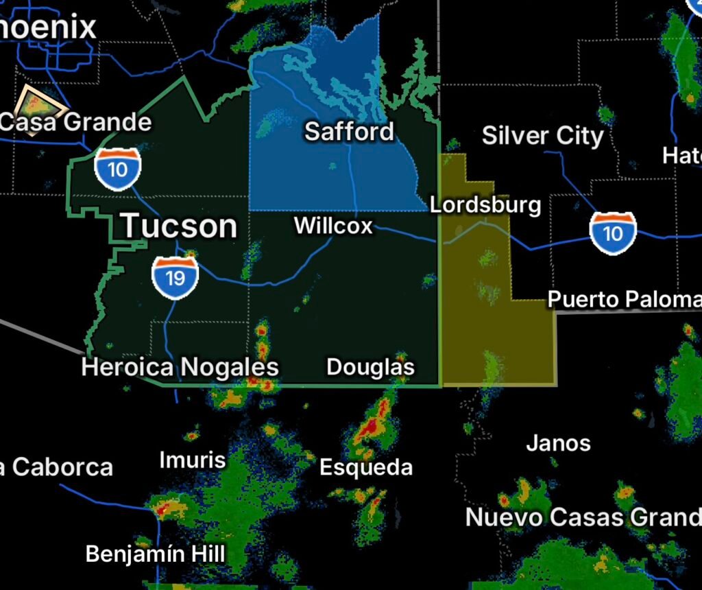
A Flood Watch is in effect across portions of southeast Arizona, covering a broad area where additional heavy rainfall could produce flooding, including rapid rises in normally dry washes, creeks, rivers, and low-lying roadways.
The watch includes portions of the Catalina and Rincon Mountains, Chiricahua Mountains, Dragoon, Mule, Huachuca and Santa Rita Mountains, Eastern Cochise County below 5,000 feet, Galiuro and Pinaleño Mountains, South Central Pinal County, Southeast Pinal County, the Tucson Metro area, Upper Gila River Valley, Upper San Pedro River Valley, and Upper Santa Cruz River Valley/Altar Valley.
The combination of mountainous terrain, monsoon moisture and locally heavy thunderstorms can create significant runoff even when rainfall at a particular location appears limited. Southern Arizona’s monsoon storms can also produce intense rainfall over relatively small areas, allowing water to quickly collect downstream and in normally dry channels.
Areas under the Flood Watch
Residents and travelers should pay close attention to changing conditions across:
- Catalina and Rincon Mountains
- Chiricahua Mountains
- Dragoon and Mule Mountains
- Huachuca Mountains
- Santa Rita Mountains
- Eastern Cochise County below 5,000 feet
- Galiuro and Pinaleño Mountains
- South Central Pinal County
- Southeast Pinal County
- Tucson Metro area
- Upper Gila River Valley
- Upper San Pedro River Valley
- Upper Santa Cruz River Valley and Altar Valley
Mountain communities and locations downstream from higher terrain can be particularly vulnerable because rainfall occurring miles away can send water rapidly into washes, channels and river valleys.
Why flooding can develop quickly
Southern Arizona’s landscape can turn heavy thunderstorm rainfall into dangerous runoff very quickly. Steep mountain slopes can funnel water toward lower elevations, while normally dry washes can fill rapidly when thunderstorms drop intense rainfall upstream.
Urban areas also face flooding concerns when heavy rain overwhelms drainage systems. Roads that appear passable at first can become hazardous as water accumulates or flows across roadways.
Recent Arizona monsoon storms have demonstrated how quickly thunderstorms can produce flooding, damaging winds, dust and power disruptions across the region. (FOX Weather)
Tucson Metro and surrounding valleys
The Tucson Metro area remains an important area to monitor because heavy rainfall can create significant street and drainage issues even away from the mountains.
Residents should watch for water accumulating in low spots, underpasses and drainage channels. Motorists should never assume that a flooded roadway is safe simply because the water appears shallow.
The Upper Santa Cruz River Valley and Altar Valley, along with the Upper San Pedro River Valley and Upper Gila River Valley, can also experience rapidly changing conditions as storm runoff moves downstream.
Mountain areas could send runoff downstream
The Catalina, Rincon, Santa Rita, Huachuca, Chiricahua, Dragoon, Mule, Galiuro and Pinaleño Mountains are capable of producing concentrated rainfall from slow-moving or repeatedly developing thunderstorms.
That means communities located below the mountains should not focus exclusively on rainfall occurring directly overhead. Heavy precipitation upstream can create dangerous water movement downstream after the strongest storms have moved away.
Cochise and Pinal County concerns
In Eastern Cochise County below 5,000 feet, residents should remain alert for rapidly changing conditions around washes, low-water crossings and rural roadways.
Flooding concerns also extend into South Central and Southeast Pinal County, where heavy thunderstorms can produce localized flooding and difficult travel conditions.
Power outage concerns
Graham County is also experiencing power outage concerns. Residents without electricity should keep emergency supplies accessible, including flashlights, backup batteries, charged mobile devices and essential medications.
Hidalgo County is also reporting power outage concerns. Residents in affected areas should monitor their local utility for restoration information and avoid downed power lines or damaged electrical equipment.
A current nationwide outage dataset is being updated today, underscoring the need for residents dealing with storm-related outages to rely on their utility’s latest restoration information rather than assuming a specific restoration time. (ArcGIS Services)
Flood safety remains critical
If a Flood Watch is posted, conditions are favorable for flooding, but flooding is not guaranteed at every location. Residents should be prepared to act quickly if warnings are issued or water begins rising.
Remember:
- Never drive through a flooded roadway.
- Do not walk or play in moving floodwater.
- Turn around if water covers the road ahead.
- Stay away from washes, arroyos and rapidly flowing drainage channels.
- Move to higher ground if water begins approaching your location.
- Keep children and pets away from floodwater.
- Do not approach downed power lines following thunderstorms.
- Monitor weather alerts, especially when thunderstorms are developing nearby or upstream.
What to watch next
The greatest concern is the potential for thunderstorms to repeatedly develop over the same areas or move across already saturated drainage basins. Even isolated storms can produce intense rainfall capable of creating localized flooding.
Residents across southeast Arizona should continue monitoring official weather information throughout the watch period, particularly when traveling through mountain passes, rural roads, washes and low-water crossings.
Stay weather-aware, avoid flooded roads and be prepared to move to higher ground if conditions deteriorate.