Heavy Rain, Severe Storms and Flash Flooding Threaten Cochise County and Surrounding Mountain Communities
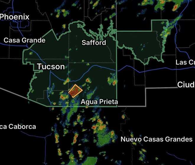
Southeast Arizona is facing an active round of thunderstorms and heavy rainfall today, with a Flash Flood Warning and Severe Thunderstorm Warning in effect for west-central Cochise County while broader areas remain under Flood Watches.
The National Weather Service is monitoring the potential for intense rainfall, rapidly rising water and strong thunderstorms across portions of Cochise, Pinal, Graham, Greenlee and surrounding areas. The current setup is especially concerning because storms can repeatedly develop over the same locations, allowing rainfall to accumulate quickly.
Flash Flood Warning for West-Central Cochise County
A Flash Flood Warning is in effect for west-central Cochise County, where thunderstorms are producing or capable of producing rainfall heavy enough to cause rapid flooding.
Flash flooding can develop quickly in southeastern Arizona, particularly around washes, normally dry stream channels, low-water crossings and areas downstream from higher terrain. Water can also move into roadways and drainage areas with little warning.
Residents and travelers within the warned area should avoid flooded roadways and never attempt to cross a flooded wash. Even shallow-looking water can conceal a damaged roadway or carry a vehicle downstream.
Severe Thunderstorm Warning for West-Central Cochise County
West-central Cochise County is also under a Severe Thunderstorm Warning, highlighting an additional threat from strong thunderstorms.
Severe storms can produce damaging wind gusts, frequent lightning, intense rainfall and sudden reductions in visibility. Outdoor activities should be moved indoors while the warning remains in effect.
The combination of severe thunderstorms and flash flooding makes travel particularly hazardous. Heavy rain can quickly overwhelm drainage systems and create dangerous conditions on roads while strong winds and lightning add additional hazards.
Flood Watch Covers Much of Southeast Arizona
A broader Flood Watch covers a large portion of southeast Arizona, including:
- Catalina and Rincon Mountains
- Chiricahua Mountains
- Dragoon and Mule Mountains
- Huachuca and Santa Rita Mountains
- Eastern Cochise County below 5,000 feet
- Galiuro and Pinaleno Mountains
- South-central Pinal County
- Southeast Pinal County
- Tucson Metro Area
- Upper Gila River Valley
- Upper San Pedro River Valley
- Upper Santa Cruz River Valley/Altar Valley
The National Weather Service indicates that above-normal moisture is supporting scattered to numerous showers and thunderstorms across southern Arizona. Stronger storms may produce substantial rainfall, with areas that have already received rain more vulnerable to additional flooding. (Weather Underground)
Flood Watch Extends Into Southwestern New Mexico
The flooding concern also extends eastward into southwestern New Mexico, where a Flood Watch covers most of Grant County and far western Sierra County, including the Black Range and Gila Wilderness.
Mountainous terrain can increase the potential for rapid runoff as heavy thunderstorms develop. Water flowing out of higher elevations can reach lower areas and washes even when rainfall is not occurring directly overhead.
Why Flash Flooding Can Develop So Quickly
Southeastern Arizona’s rugged terrain makes flash flooding a particular concern during periods of heavy thunderstorms. Rain falling over mountains and higher terrain can rapidly drain into washes, creeks and normally dry channels.
A location may experience little or no rain while water from a stronger storm upstream moves into the area. This is why people near washes and low-water crossings should remain alert even when skies overhead do not appear particularly threatening.
The National Weather Service has emphasized that excessive runoff can cause flooding of rivers, creeks, streams and other low-lying or flood-prone locations, with washes and drainage areas responding quickly to intense rainfall. (Weather Underground)
What Residents Should Do
Anyone inside a Flash Flood Warning should take immediate action and move away from washes, creeks and other flood-prone areas.
During a Flood Watch, residents should remain weather-aware and be prepared to move to higher ground if a warning is issued.
If you encounter water covering a roadway, turn around and find another route. Do not drive through it.
During severe thunderstorms:
- Move indoors when storms approach.
- Stay away from windows during strong winds.
- Avoid exposed outdoor areas.
- Take lightning seriously even if the storm is not directly overhead.
- Secure loose outdoor objects when strong winds are approaching.
- Never enter a flooded wash or roadway.
The National Weather Service continues to monitor conditions across southern Arizona as thunderstorms develop and move through the region. (National Weather Service)
Stay Weather Aware Across Southeast Arizona
The combination of active thunderstorms, saturated areas and additional heavy rainfall means conditions can change rapidly across Cochise County, the Tucson region, southeastern Pinal County, the surrounding mountain ranges and into southwestern New Mexico.
A Flood Watch means flooding is possible; a Flash Flood Warning means dangerous flooding is occurring or imminent in the warned area. Residents should monitor updated forecasts and warnings throughout the day and be prepared to act quickly if conditions deteriorate.
Stay alert, avoid flooded roads and washes, and give rapidly rising water plenty of distance.