Special Weather Statement Also Covers Boone County Communities as Wet Weather Develops Across the Central Plains
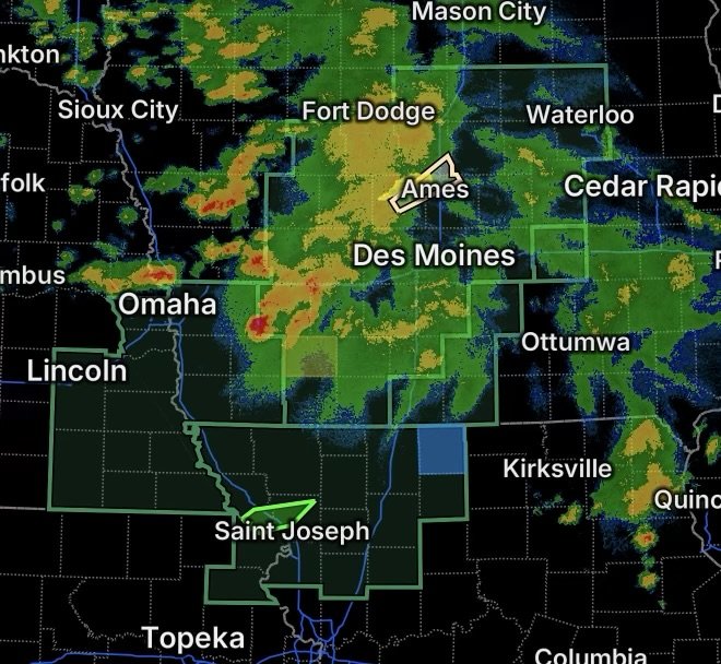
A broad area of the central Plains and Midwest is facing an increasingly wet weather pattern, with Flood Watches and Flood Warnings covering portions of Iowa, Missouri, Kansas and Nebraska. Additional weather concerns are affecting communities around Boone County, Iowa, where a Special Weather Statement includes several communities, transportation corridors and recreational areas.
The National Weather Service is highlighting the potential for heavy rainfall and excessive runoff across parts of the region. Current guidance shows the potential for flooding to continue developing as additional rainfall moves across already vulnerable areas.
Special Weather Statement Covers Boone County Area
A Special Weather Statement is in effect for portions of the Boone County area, including:
- Boone
- Story City
- Roland
- Gilbert
- Boone Speedway
- McCallsburg
- Randall
- Boone Municipal Airport
- Ledges State Park
A Special Weather Statement is used to provide information about weather conditions that may affect an area but do not necessarily meet the criteria for a formal warning.
Residents and travelers in these locations should continue monitoring changing conditions, particularly if thunderstorms and heavy rainfall develop. Sudden reductions in visibility, ponding water and difficult driving conditions can occur during periods of intense rain.
Those visiting Ledges State Park or other outdoor locations should also be prepared to move to a safer location if thunderstorms become stronger or conditions deteriorate.
Flood Watch Covers Much of Iowa
A Flood Watch covers portions of southwestern, central and northeastern Iowa.
The watch means conditions are favorable for flooding, including possible flooding of:
- Rivers
- Creeks
- Streams
- Low-lying areas
- Poor-drainage locations
- Roads and underpasses
The concern is not limited to areas immediately receiving the heaviest rain. Runoff from upstream locations can cause water levels to rise downstream, while repeated rounds of rainfall can overwhelm drainage systems.
Iowa State’s Environmental Mesonet is also highlighting an unusually wet weather pattern, with widespread rainfall expected across the state during the week and the potential for locally higher totals.
Flood Warnings Continue in Northwestern Missouri
Flood Warnings are affecting portions of northwestern Missouri, including:
- Central Andrew County
- Southeastern Holt County
A Flood Warning means flooding is occurring, imminent or already creating hazardous conditions within the warned area.
Residents in these areas should avoid flooded roads and never attempt to drive through water covering a roadway. Even relatively shallow moving water can sweep a vehicle from the road.
Flood Watch Expands Across Northeast Kansas and Missouri
A broad Flood Watch also covers portions of northeast Kansas and northern Missouri.
In Kansas, the watch includes:
- Atchison County
In Missouri, the watch includes:
- Andrew County
- Atchison County
- Buchanan County
- Caldwell County
- Clinton County
- Daviess County
- De Kalb County
- Gentry County
- Grundy County
- Harrison County
- Holt County
- Mercer County
- Nodaway County
- Worth County
This area could experience additional flooding problems as rainfall accumulates and runoff increases.
Communities near rivers, creeks and smaller streams should pay particular attention to changing water levels. Areas that have experienced previous rainfall may see flooding develop more quickly because the ground and drainage systems have less capacity to absorb additional water.
Southwest Iowa and Eastern Nebraska Also Under a Flood Watch
The flood threat extends westward into southwest Iowa and eastern Nebraska.
In Iowa, the Flood Watch includes:
- Fremont County
- Mills County
- Montgomery County
- Page County
- Pottawattamie County
In Nebraska, the watch includes:
- Cass County
- Douglas County
- Gage County
- Johnson County
- Lancaster County
- Nemaha County
- Otoe County
- Pawnee County
- Richardson County
- Sarpy County
The combination of widespread rainfall and additional thunderstorms could produce areas of excessive runoff. Urban locations may experience rapid water accumulation where drainage systems become overwhelmed.
What Residents Should Watch For
The most important concern is water rising faster than expected.
Residents should monitor official weather updates and be prepared for changes in road conditions. If a Flood Warning is issued for a location, take the warning seriously and avoid entering flooded areas.
Watch for:
- Water covering roads
- Rapidly rising creeks and streams
- Flooding in low-lying areas
- Water entering streets or buildings
- Reduced visibility during heavy rain
- Road closures
- Strong thunderstorms accompanying heavy rainfall
If water covers a roadway, Turn Around, Don’t Drown. Do not drive around barricades or attempt to judge whether floodwater is shallow enough to cross.
A Wet Pattern Could Continue to Create Problems
The current setup is more than a single isolated rainfall event. Forecast guidance and regional observations point toward a very wet stretch across portions of the Midwest, increasing the potential for repeated rainfall and additional runoff.
That makes it especially important for residents in flood-prone locations to remain weather-aware even after rainfall temporarily ends. Flooding can continue or worsen after the heaviest rain has moved away as water drains into rivers, streams and low-lying areas.
Radar Watch HQ Final Thoughts
The combination of a Special Weather Statement, Flood Watches and Flood Warnings makes this an important period for weather awareness across Iowa, Missouri, Kansas and Nebraska.
Residents should keep phones charged, monitor local weather information, avoid flooded roadways and be prepared to move to higher ground if flooding develops. Conditions can change quickly, especially when thunderstorms produce intense rainfall over the same area.
Stay weather-aware, know your flood risk, and always take official warnings seriously.