Weather Conditions Prompt Multiple Statements Across Northeast Florida and Southeast Georgia
Several weather-related statements are affecting portions of Northeast Florida and Southeast Georgia on Monday, September 14, as inland areas deal with locally changing weather conditions and beach communities face an elevated risk from rip currents.
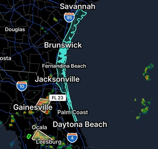
The National Weather Service Jacksonville office is highlighting Special Weather Statements for portions of Bradford, Alachua, Putnam, Clay and Marion Counties, while a Rip Current Statement covers beaches across Southeast Georgia and Northeast Florida.
These products address different hazards, but each serves as an important reminder to remain aware of changing conditions.
Special Weather Statement for Four Northeast Florida Counties
A Special Weather Statement covers southeastern Bradford County, northeastern Alachua County, northwestern Putnam County and southwestern Clay County.
Special Weather Statements are used by the National Weather Service to highlight weather conditions that may not meet warning criteria but could still affect people, travel or outdoor activities.
Residents in these areas should remain alert for changing conditions and continue monitoring updated forecasts throughout the day.
The broader Northeast Florida forecast calls for continued heat along with afternoon and evening thunderstorms. The National Weather Service Jacksonville forecast discussion notes that the primary thunderstorm hazards can include locally heavy rain, lightning and gusty winds, with some wind gusts potentially reaching 40 to 50 mph.
Anyone outdoors should be prepared to move inside quickly if thunderstorms develop.
Special Weather Statement for South Central Marion County
A separate Special Weather Statement covers south central Marion County.
Marion County and surrounding portions of North Central Florida remain within a warm and humid weather pattern. Forecast information from the National Weather Service indicates that afternoon temperatures can reach the 90s, with heat index values potentially climbing into the triple digits.
Thunderstorms remain possible during the afternoon and evening. Heavy downpours, frequent lightning and gusty winds can develop quickly even when skies are initially quiet.
People spending time outdoors should take thunderstorm development seriously. If thunder is heard, move indoors and wait until the storm has passed.
Rip Current Statement Covers Area Beaches
Along the Atlantic coast, a Rip Current Statement is highlighting dangerous swimming conditions for beaches in Southeast Georgia and Northeast Florida.
The National Weather Service’s latest surf forecast places the local beaches under a moderate rip current risk. This includes beaches around Nassau, Duval, Flagler and St. Johns Counties in Northeast Florida, as well as Glynn and Camden Counties in Southeast Georgia.
A moderate rip current risk means life-threatening rip currents are possible in the surf zone.
Rip currents can pull swimmers away from the shoreline rapidly, including people who are otherwise strong swimmers.
Beach Safety Remains Important
Beachgoers should check local beach flags and follow instructions from lifeguards and beach patrols.
If caught in a rip current, do not attempt to swim directly against the current toward shore. Instead, remain calm and swim parallel to the shoreline until escaping the current, then swim toward shore.
People who are not strong swimmers should avoid entering the surf when dangerous conditions are present.
The National Weather Service also notes that rip currents can occur near structures such as piers, jetties and groins, even when the overall risk category is lower.
Heat and Thunderstorms Add Another Layer
The coastal hazards are occurring alongside a broader period of September heat across Northeast Florida and Southeast Georgia.
The National Weather Service Jacksonville office says heat index values could reach 100° to 107° across the region, while daily afternoon and evening thunderstorms remain possible.
That combination means outdoor plans should account for both heat exposure and rapidly developing thunderstorms.
Drink plenty of water, take breaks from the heat and avoid prolonged outdoor activity during the hottest part of the afternoon.
What to Watch Today
For residents across the affected areas, the main concerns include:
- Localized weather impacts across portions of Bradford, Alachua, Putnam and Clay Counties.
- Additional weather concerns in south central Marion County.
- Afternoon and evening thunderstorms across portions of North Central and Northeast Florida.
- Lightning, heavy rainfall and gusty winds with stronger storms.
- Moderate rip current risk along Northeast Florida and Southeast Georgia beaches.
- Dangerous swimming conditions in areas affected by rip currents.
- Heat index values potentially reaching 100° to 107° across the region.
Weather conditions can change quickly, so residents and visitors should continue checking the latest National Weather Service information and local conditions throughout the day.
Stay weather-aware, know the hazards affecting your area, and make safety the priority before heading outdoors or into the water.