
Dry Air, Gusty Winds and a Power Outage Put Fire-Prone Communities on Alert
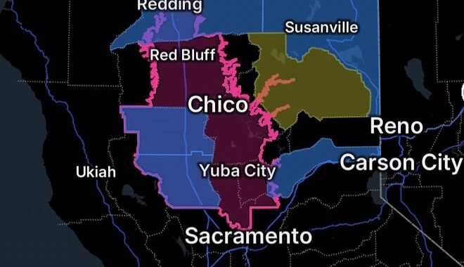
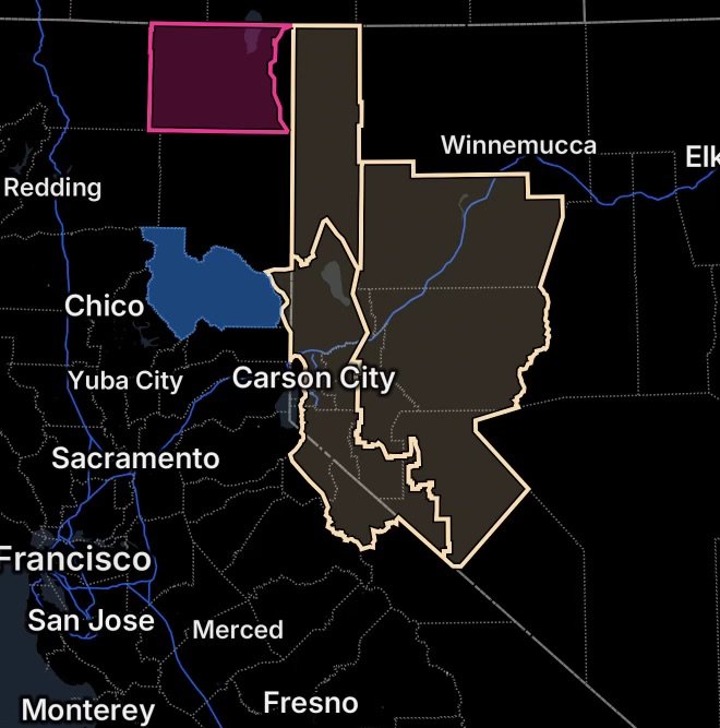
Northern California and western Nevada are facing a heightened wildfire-weather setup as a Red Flag Warning covers most of Modoc County, while Fire Weather Watches are in effect for parts of northern Nevada and the Sierra Front. A reported power outage in Plumas County adds another concern for residents preparing for potentially difficult weather conditions.
The National Weather Service says the combination of strong winds and low humidity can allow any new fire to spread rapidly. These alerts are about weather conditions favorable for fire growth and do not mean that a wildfire is currently burning in every affected area. (National Weather Service)
Red Flag Warning: Modoc County
A Red Flag Warning remains in effect for Modoc County except for the Surprise Valley from 2 p.m. to 8 p.m. PDT Thursday.
Forecast conditions include:
- Southwest winds of 12 to 20 mph
- Wind gusts of 30 to 35 mph
- Daytime relative humidity as low as 11% to 15%
- Very dry vegetation that can support rapid fire growth
The National Weather Service warns that fires developing under these conditions could spread rapidly. Residents should follow local fire restrictions and avoid activities that could create a spark around dry vegetation. (National Weather Service)
What Modoc County Residents Should Know
The most critical period is expected during the afternoon and evening when winds strengthen and humidity falls.
Residents in the affected portion of Modoc County should have emergency supplies ready, know multiple ways to receive official information, and be prepared to act quickly if evacuation orders or other emergency instructions are issued.
Fire Weather Watch: Northern Washoe County
A Fire Weather Watch is in effect for Northern Washoe County from Friday afternoon through Friday evening.
The National Weather Service forecasts:
- Southwest to west winds of 15 to 25 mph
- Gusts up to 40 mph
- Afternoon relative humidity falling to approximately 20% to 25%
- Winds shifting northerly Friday evening and overnight
The combination of wind and low humidity could allow a wildfire to grow quickly before firefighters can contain it. Outdoor activities capable of producing sparks should be avoided near dry vegetation, including campfires and certain yard work. (National Weather Service)
Fire Weather Watch: Lahontan and West Humboldt Basins
The Lahontan Basin, including Churchill and eastern Mineral counties, and the West Humboldt Basin in Pershing County are also under a Fire Weather Watch for Friday afternoon through Friday evening.
Forecast conditions include:
- Southwest to west winds of 15 to 25 mph
- Gusts up to 40 mph
- Relative humidity dropping to approximately 12% to 17%
- Winds shifting toward the north Friday evening and overnight
These extremely dry conditions combined with stronger winds can make any fire difficult to control and allow flames to spread rapidly through dry fuels. (National Weather Service)
Fire Weather Watch: Northern Sierra Front
The Northern Sierra Front, including portions of Carson City, Douglas, Storey, southern Washoe, western Lyon and far southern Lassen counties, is included in the Fire Weather Watch.
The National Weather Service is forecasting:
- Southwest winds around 20 to 30 mph
- Gusts up to 45 mph
- Afternoon humidity falling to approximately 15% to 20%
- A period of elevated fire-weather conditions lasting several hours
The watch also covers the Southern Sierra Front, including portions of Alpine, northern Mono, southern Lyon and western Mineral counties. (National Weather Service)
Plumas County Power Outage Adds Another Preparedness Concern
A power outage is being reported in Plumas County as residents across the region contend with elevated fire-weather concerns.
Power outages can create additional challenges during periods of heightened wildfire danger. Residents should keep phones and backup batteries charged, have flashlights available, and maintain access to important emergency information if electricity or internet service becomes temporarily unavailable.
Plumas County’s emergency planning documents note that Public Safety Power Shutoffs can be considered during high-fire-risk weather when factors such as low humidity, strong winds and dry fuels create increased wildfire potential. (Plumas County)
Why These Conditions Matter
Wildfire danger increases when several atmospheric and surface conditions occur at the same time.
Low humidity removes moisture from vegetation and other fuels. Strong winds can rapidly push flames into new areas and carry embers ahead of a fire. When vegetation is already dry, the combination can create a fast-moving fire environment.
That is why the National Weather Service issues Fire Weather Watches and Red Flag Warnings when these ingredients are expected to overlap.
Safety Steps for Residents
During elevated fire-weather conditions:
- Follow all local fire restrictions.
- Avoid campfires and other activities that can create sparks.
- Do not burn debris when fire restrictions prohibit it.
- Avoid parking vehicles on or near dry grass where hot exhaust components could ignite vegetation.
- Secure anything outdoors that could become hazardous in strong winds.
- Keep phones, backup batteries and emergency devices charged.
- Know at least two ways to receive emergency information.
- If a wildfire threatens your community, follow evacuation instructions from local officials immediately.
- Never wait for visible flames or smoke before taking an evacuation order seriously.
Radar Watch HQ Final Thoughts
The combination of very low humidity and gusty winds creates an elevated wildfire-weather threat across portions of Northern California and Nevada. Modoc County is under a Red Flag Warning, while Northern Washoe County, the Lahontan and West Humboldt Basins, and the Sierra Front are being monitored under Fire Weather Watches.
With dry fuels across the region, residents should take fire restrictions seriously and avoid activities that could accidentally start a fire. Those experiencing power outages should also prepare for the possibility of extended interruptions by conserving battery power and keeping emergency supplies accessible.
Stay informed through the National Weather Service, local emergency management agencies and local fire officials as conditions evolve.
Stay weather-aware, stay prepared, and remember: one spark can become a wildfire when conditions are dry and windy.