

Severe Coastal Storm Threat Expands Along the Northeast Coast
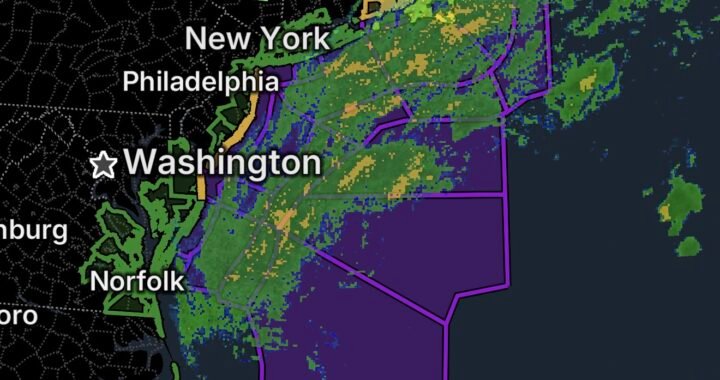
A broad and strengthening coastal storm is creating a significant stretch of hazardous weather along the Atlantic coast today, with marine storm watches, coastal flooding, dangerous surf and strong winds affecting areas from the Mid-Atlantic through New England.
The National Weather Service has issued multiple watches and warnings as the storm system develops offshore. Conditions are expected to remain hazardous for marine interests, coastal communities and beachgoers through the coming days.
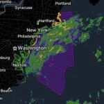
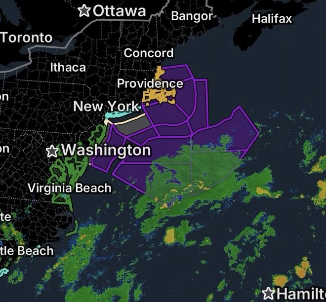
Storm Watch From Sandy Hook, New Jersey, to Montauk Point, New York
A Storm Watch is in effect for Atlantic waters extending from Sandy Hook, New Jersey, to Montauk Point, New York, from 20 to 60 nautical miles offshore.
The National Weather Service says northeast winds could reach 30 to 40 knots, with gusts up to 55 knots, while seas could build to 13 to 18 feet. The Storm Watch is scheduled from Thursday evening through Friday afternoon.
These conditions can create dangerous situations for smaller vessels and offshore operations. Mariners should be prepared to remain in port, seek safe harbor or secure vessels before the strongest conditions arrive.
Additional Atlantic coastal waters are also under a Storm Watch as the storm’s circulation and wind field expand.
Coastal Flooding From Maryland Into Virginia
Coastal flooding is another major concern, particularly around tidal rivers, bays, inlets and vulnerable shoreline communities.
Dorchester, Wicomico and Somerset Counties
A Coastal Flood Warning remains in effect for Dorchester, Wicomico and Somerset Counties in Maryland through 4 AM Friday.
The NWS expects 1 to 2 feet of inundation above ground level in low-lying areas near shorelines and tidal waterways. Flooding can extend inland along tidal rivers and bays, potentially closing roads and affecting vehicles, homes and businesses.
Anne Arundel County
The shoreline of Anne Arundel County, Maryland, is also under a Coastal Flood Warning through 11 AM Friday, particularly around high tide.
Up to 1 foot of inundation above ground level is expected in vulnerable locations. The NWS notes that water can approach businesses around Dock Street in Annapolis, while the City Dock parking area and portions of Compromise Street can experience flooding.
Eastern and East-Central Virginia
A Coastal Flood Warning continues across Westmoreland, Richmond, Northumberland, Lancaster, Middlesex, Mathews, Western Essex and Eastern Essex Counties through 8 AM Friday.
The NWS expects 2 to 3 feet of inundation above ground level in low-lying areas near shorelines and tidal waterways. Such water levels can close roads and threaten homes and businesses near the waterfront.
A separate Coastal Flood Warning covers Prince George County, including Hopewell, Charles City, Surry, James City, Isle of Wight and Newport News through 4 PM Friday. Inundation of 1 to 2 feet above ground level is expected in vulnerable shoreline locations.
New York Beaches Face Dangerous Rip Currents
Beach hazards are also elevated along parts of Long Island and New York City.
A Rip Current Statement is in effect for southwest Suffolk County, while another covers Kings County (Brooklyn) and Southern Queens County.
Strong northeast winds, elevated surf and persistent wave energy can increase the risk of powerful rip currents. Swimmers should use beaches with lifeguards and avoid entering the water when conditions become dangerous.
The National Weather Service’s New York office is also reporting an ongoing rip-current hazard along portions of Long Island.
High Wind Threat Reaches Southern New England
The storm threat is also increasing across eastern Massachusetts and the south coasts of Massachusetts and Rhode Island, where a High Wind Warning is in effect.
The developing coastal system is expected to produce powerful northeast winds across the region. The Boston/Norton NWS coastal forecast warns that northeast wind gusts could reach 35 to 55 knots, with seas potentially building to 15 to 20 feet or higher by the weekend.
The strongest winds can create problems for exposed coastal locations, unsecured outdoor objects, trees and power infrastructure. Residents should be prepared for possible outages and difficult travel, particularly near exposed shorelines and bridges.
Why This Storm Is Producing So Many Coastal Hazards
The storm is developing in an environment where strong pressure differences and persistent northeast winds are pushing water toward the coastline.
That setup can produce several hazards at the same time:
- Coastal water levels rise above normal.
- Waves become larger and more powerful.
- Rip currents strengthen near beaches.
- Strong winds can create dangerous marine conditions.
- Low-lying roads and waterfront properties become more vulnerable to flooding.
- Offshore vessels face rapidly deteriorating conditions.
The NWS says a slow-moving and intensifying ocean storm is expected to remain a concern into the weekend, with the exact track and timing still subject to some uncertainty.
Safety Reminders for Coastal Residents and Mariners
If you live near the coast, keep monitoring updated local forecasts as the storm evolves.
For residents in flood-prone areas:
- Move vehicles and valuables away from areas that routinely flood.
- Avoid driving through flooded roads.
- Follow local evacuation or road-closure instructions.
- Be especially alert around high tide.
For beachgoers:
- Avoid swimming in rough surf or strong current conditions.
- Use lifeguarded beaches whenever possible.
- Never attempt to swim against a rip current; move parallel to the shoreline until free of the current, then head toward shore.
For boaters and mariners:
- Avoid heading offshore during Storm Watch conditions.
- Secure vessels before winds and seas increase.
- Check the latest marine forecasts before making any trip.
- Remain in port or seek safe harbor when conditions deteriorate.
Radar Watch HQ Final Thoughts
The Northeast is entering a prolonged period of coastal weather concerns, with marine storm conditions, coastal flooding, high winds and dangerous surf occurring across several states.
From New Jersey and New York to Maryland, Virginia, Rhode Island and Massachusetts, residents and mariners should take the current watches and warnings seriously and continue monitoring the latest National Weather Service updates as the coastal storm evolves.
Stay weather-aware, know your local flood and evacuation routes, and make preparations before conditions worsen.