Coastal Hazards and River Flooding Affect Multiple Communities
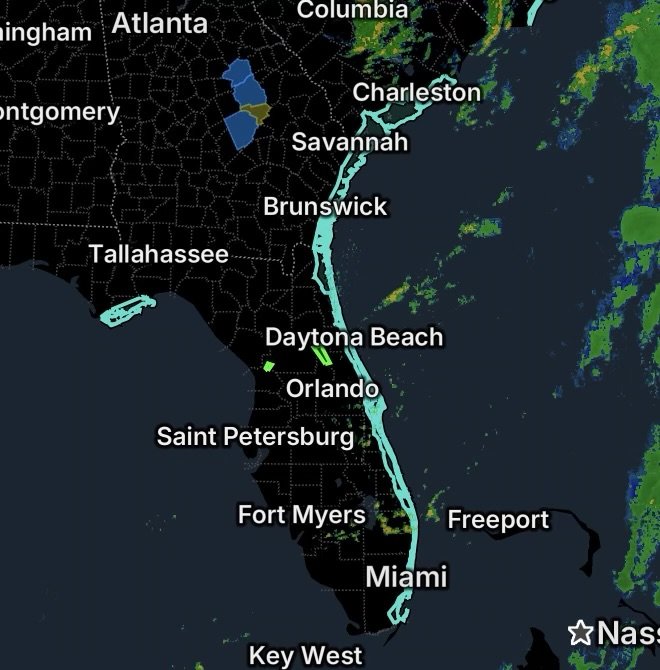
Thursday, September 24, 2026, brings a combination of dangerous beach conditions and ongoing river flooding across portions of Florida, Georgia and South Carolina. National Weather Service alerts include High Rip Current Risks along numerous Atlantic and Gulf Coast beaches, along with Flood Warnings for the Withlacoochee River near Dunnellon and the St. Johns River near Astor.
These hazards are different, but both require people to pay close attention to conditions near water.
High Rip Current Risk Along Florida Beaches
Franklin County Beaches
A High Rip Current Risk is in effect for the beaches of Franklin County beginning this afternoon and continuing through Friday afternoon. The National Weather Service says breezy northeast winds behind a cold front are expected to produce a longshore current along St. George Island, with surf around 2 feet.
Even when waves do not appear especially large, rip currents can move quickly away from shore and become dangerous for swimmers.
Broward and Miami-Dade Counties
A High Rip Current Risk is scheduled for Coastal Broward County and Coastal Miami-Dade County from Friday afternoon through Saturday morning. Dangerous rip currents are expected along the beaches.
Beachgoers should check local beach flags, follow lifeguard instructions and avoid entering the water when conditions are considered unsafe.
Indian River, Saint Lucie, Martin and Brevard Counties
A broad stretch of Florida’s east-central coastline is also under a High Rip Current Risk from Thursday morning through late Friday night.
The affected areas include:
- Coastal Indian River County
- Coastal Saint Lucie County
- Coastal Martin County
- Mainland Northern Brevard
- Northern Brevard Barrier Islands
- Mainland Southern Brevard
- Southern Brevard Barrier Islands
The National Weather Service also has a High Surf Advisory covering these areas, with breaking waves of 4 to 8 feet expected in the surf zone.
Coastal Volusia County
Coastal Volusia County is facing the same combination of elevated beach hazards, including a High Rip Current Risk through late Friday night and a High Surf Advisory through early Saturday morning.
The National Weather Service expects breaking waves of approximately 4 to 8 feet in the surf zone. A Coastal Flood Advisory is also scheduled around the Friday high-tide period.
Southeast Georgia and Northeast Florida Beaches
The Atlantic coastline covering Southeast Georgia and Northeast Florida Beaches is under a High Rip Current Risk through late Saturday night.
The National Weather Service is also forecasting 6 to 8-foot breaking waves and minor coastal flooding around times of high tide.
The combination of stronger surf and rip currents can make swimming conditions particularly dangerous, even for experienced swimmers.
Coastal Colleton and Charleston Counties
Along the South Carolina coast, Coastal Colleton and Charleston Counties remain under a High Rip Current Risk through 8 PM Thursday.
A Coastal Flood Advisory is also in effect from 5 PM to 10 PM Thursday, with up to approximately one foot of inundation possible above ground level along shorelines and tidal waterways.
People visiting beaches should account for both surf hazards and rising water near tidal areas.
Flood Warning: Withlacoochee River at US 41 in Dunnellon
Away from the beaches, the Withlacoochee River at US 41 near Dunnellon remains under a Flood Warning until further notice.
The river was around 28.2 feet Thursday morning, which is at flood stage, and the National Weather Service expects it to remain near or slightly above flood stage during the coming days. At this level, docks and boat ramps can become flooded along portions of the river in Citrus and Marion counties.
The NWS also reports that excessive hydrilla growth along a roughly 4.5-mile stretch between US 41 and Lake Rousseau is restricting water movement and contributing to the elevated river levels.
People near the river should avoid flooded access points and use caution around riverbanks.
Flood Warning: St. Johns River Near Astor
A new Flood Warning is in effect for the St. Johns River near Astor, affecting Lake and Volusia counties.
The river was at 2.3 feet Thursday morning, which is flood stage, and the forecast calls for the river to continue rising, reaching an estimated crest of 2.8 feet Sunday morning.
At the projected level, the NWS says water could cover docks and boat ramps at several locations, approach structures and inundate portions of roads and yards near the river.
Northerly winds and tidal effects are contributing to the continued rise.
Rip Current Safety
Rip currents can pull swimmers away from the shoreline even when the ocean surface does not appear extremely dangerous.
If caught in a rip current:
- Do not swim directly against the current.
- Stay calm and float to conserve energy.
- If possible, swim parallel to the shoreline until you are out of the current.
- Once free of the current, swim toward shore.
- If you cannot escape, face the shore and call or wave for help.
- Swim near a lifeguard whenever possible.
The safest option during a High Rip Current Risk is to remain out of the surf, particularly when high surf and strong currents are occurring together.
River Flood Safety
Flooded roads, boat ramps and river access areas can become hazardous quickly.
Never drive through flooded roadways or around barricades. Water can hide washed-out pavement, debris and rapidly changing depths. Keep away from swollen rivers and riverbanks, especially where water is already covering normally dry areas.
Radar Watch HQ Final Thoughts
From the Gulf Coast of Florida to the Atlantic beaches of Florida, Georgia and South Carolina, water-related hazards are the primary concern today. High Rip Current Risks are affecting multiple beach regions, while Flood Warnings remain in effect along the Withlacoochee and St. Johns Rivers.
Before heading to the beach, check current beach flags and lifeguard guidance. For those living or traveling near the affected rivers, monitor water levels and avoid flooded roads, docks and low-lying areas.
Stay weather-aware, know the hazards in your area, and follow guidance from local officials and the National Weather Service.