Tropical Storm Isaias and Gulf Coast Hazards
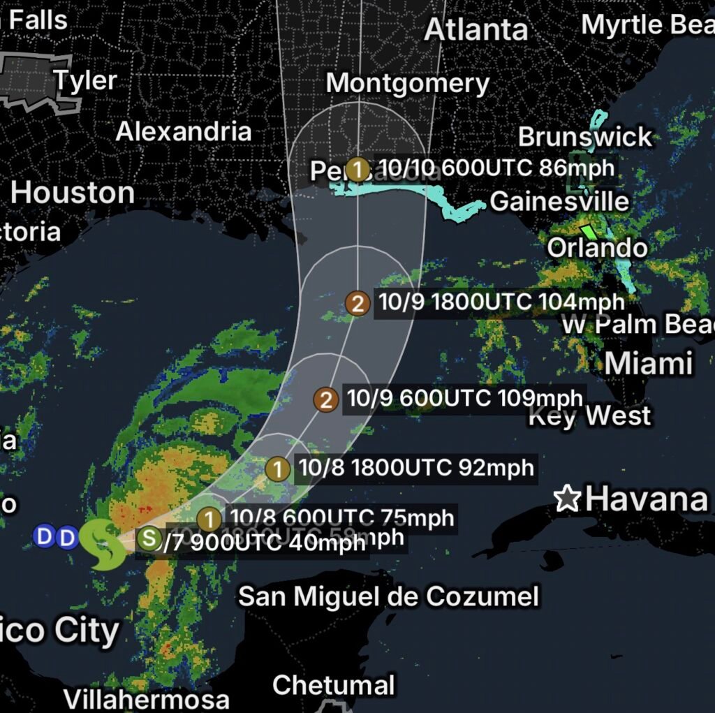
Tropical Storm Isaias is contributing to an active weather pattern across portions of the Gulf Coast and Southeast, with coastal and inland hazards affecting parts of Florida, Alabama and Georgia on Wednesday, October 7, 2026.
The main concerns include dangerous rip currents, river flooding and additional flooding from heavy rainfall.
Residents and visitors along the Gulf and Atlantic-facing beaches should check local conditions before heading into the water, while communities in flood-prone areas should remain alert for rising water.
Dangerous Rip Currents Along Gulf Coast Beaches
A Rip Current Statement is in effect for numerous beaches along the northern Gulf Coast.
Florida
Affected coastal areas include:
- Escambia Coastal
- Santa Rosa Coastal
- Okaloosa Coastal
- Walton County beaches
- Bay County beaches
- Gulf County beaches
- Franklin County beaches
Strong rip currents can pull swimmers away from shore and become dangerous even when waves do not appear particularly large.
Beachgoers should remain near lifeguards and follow posted beach warnings.
Alabama
Rip-current hazards are also affecting:
- Mobile Coastal
- Baldwin Coastal
Anyone visiting Alabama beaches should use caution around the surf and avoid entering the water when conditions are considered dangerous.
Rip Current Hazards Along Florida’s Atlantic Coast
The threat is not limited to the Gulf Coast.
A Rip Current Statement is also affecting portions of Florida’s Atlantic coastline, including:
- Coastal Volusia County
- Coastal Brevard County
Swimmers should never underestimate the strength of a rip current. If caught in one, remain calm and swim parallel to the shoreline until free from the current before heading back toward the beach.
Georgia Beaches Also Face Dangerous Rip Currents
A Rip Current Statement is in effect for the Georgia beaches.
The combination of coastal weather, waves and currents can create hazardous swimming conditions.
Beach visitors should check local beach flags and follow lifeguard instructions before entering the water.
Flood Warning for the St. Johns River Near Astor
Inland flooding is another concern across Florida.
A Flood Warning is in effect for the St. Johns River near Astor.
River flooding can persist even after rainfall decreases because water continues moving downstream through the river system.
Residents near the St. Johns River should avoid entering flooded areas and should never attempt to drive across a flooded roadway.
Turn Around, Don’t Drown!
Floodwater can hide washed-out roads, debris and other hazards. Even shallow moving water can be dangerous to vehicles and pedestrians.
Flood Watch for Northeast Florida and Southeast Georgia
A Flood Watch remains in effect for portions of northeast Florida and southeast Georgia, indicating that conditions are favorable for flooding.
Periods of heavy rainfall could result in:
- 🌧️ Urban and poor-drainage flooding
- 🌊 Rising creeks and rivers
- 🚗 Dangerous travel conditions
- 🏠 Water entering low-lying areas
- ⚠️ Flash flooding in vulnerable locations
Residents under the Flood Watch should remain weather-aware and be prepared to move to higher ground if flooding develops.
Coastal Hazards Remain a Major Concern
The combination of tropical weather and coastal conditions means visitors should use extra caution along beaches and waterways.
Rip currents can become stronger and more widespread during periods of elevated surf. They can also occur on beaches that appear calm from shore.
Do not rely solely on how the water looks. Check beach conditions and follow local advisories.
Essentials: Stay Safe During Gulf Coast Hazards
🌊 Respect rip-current warnings: Stay out of the water when conditions are dangerous.
🏖️ Swim near lifeguards: If you enter the water, choose a location with lifeguard supervision.
🚗 Turn around, don’t drown: Never drive through flooded roads.
🌧️ Monitor the Flood Watch: Be prepared for rapidly changing conditions.
🏠 Know your flood risk: Move valuables and vehicles to safer locations if flooding becomes likely.
📱 Monitor tropical updates: Continue following official forecasts and local emergency information concerning Tropical Storm Isaias.
🚤 Mariners should use caution: Tropical weather can produce rapidly changing winds, waves and currents.
Bottom Line
Tropical Storm Isaias and its surrounding weather pattern are contributing to hazardous conditions across portions of the Gulf Coast and Southeast on October 7, 2026.
Dangerous rip currents are affecting beaches across Florida, Alabama and Georgia, while the St. Johns River near Astor remains under a Flood Warning and a Flood Watch covers portions of northeast Florida and southeast Georgia.
Whether you’re at the beach or traveling inland, remain alert, follow local warnings and avoid entering flooded roads or dangerous surf.