Wildfire Smoke and Critical Fire Danger: Air Quality Alerts and Fire Weather Watches Sweep Oregon and Washington
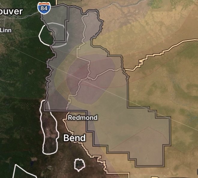
A dangerous combination of environmental threats is impacting the Pacific Northwest, bringing heavy health hazards and heightened wildfire risks to multiple communities. Persistent wildfire smoke has forced air quality advisories across several central and eastern Oregon counties, while incoming winds and dry conditions have triggered extensive Fire Weather Watches across parts of Oregon and Washington.
Residents from the high desert to the mountain valleys face a critical stretch of weather as authorities urge caution, preparation, and strict adherence to safety protocols.
Fast Facts: Regional Alerts & Affected Zones
Air Quality Alert Regions: Crook, Jefferson, Union, Wallowa, and Wasco Counties in Oregon.
Key Cities Impacted by Smoke: Prineville, Post, Paulina, Madras, Warm Springs, Culver, La Grande, Elgin, Union, North Powder, Enterprise, Joseph, Wallowa, Imnaha, Troy, Lostine, The Dalles, Maupin, Shaniko, and Tygh Valley.
Fire Weather Watch Zones (Wind & Low RH): Lower Columbia Basin of Oregon and Washington, and the Canyon Grasslands of Wallowa County.
Expanded Fire Weather Watch Zones: Northern Blue Mountains, Grande Ronde Valley, Eagle Cap Wilderness, John Day Valley, Central/Southern/Western Forested Blue Mountains, Central Mountains of Oregon, and the Blue Mountains of Washington.
Heavy Wildfire Smoke Triggers Extended Air Quality Alerts
Active wildfires burning throughout the region are pumping thick plumes of smoke into local airsheds, causing air quality to plummet to unhealthy levels. The Oregon Department of Environmental Quality (DEQ) has issued an Air Quality Advisory spanning multiple counties and communities.
Communities Under the Advisory
The advisory directly impacts residents across Crook, Jefferson, Union, Wallowa, and Wasco Counties, including populations in:
Crook County: Prineville, Post, Paulina
Jefferson County: Madras, Warm Springs, Culver
Union County: La Grande, Elgin, Union, North Powder
Wallowa County: Enterprise, Joseph, Wallowa, Imnaha, Troy, Lostine
Wasco County: The Dalles, Maupin, Shaniko, Tygh Valley
Health Impacts of Smoke Exposure
Fine particulate matter (\bm{PM_{2.5}}) and toxic gases present in heavy wildfire smoke can penetrate deep into the lungs and enter the bloodstream. Exposure frequently leads to:
Burning eyes, runny nose, and scratchy throats.
Aggravated asthma, bronchitis, and chronic obstructive pulmonary disease (COPD).
Heightened risks of cardiovascular strain for sensitive individuals, including children, older adults, and pregnant people.
Critical Fire Weather Watches Issued for Oregon and Washington
Compounding the smoke crisis, the National Service (NWS) has raised red flags regarding explosive fire growth potential. Strong winds overlapping with critically low relative humidity have prompted multiple Fire Weather Watches across eastern Oregon, southeastern Washington, and surrounding mountain zones.
What to Expect
Winds: West to northwest winds sustained at 15 to 30 mph, with potential gusts reaching up to 40 mph.
Relative Humidity: Dropping to hazardous thresholds as low as 20 to 24 percent.
Impact: Any new or existing fire ignition will catch rapidly and spread aggressively under these dry, windy parameters.
Impacted Fire Weather Zones
Columbia Basin & Canyons: Lower Columbia Basin of Oregon, Lower Columbia Basin of Washington, and the Canyon Grasslands of Wallowa County.
Mountain and Valley Terrain: Northern Blue Mountains of Oregon, Grande Ronde Valley, Eagle Cap Wilderness, John Day Valley, Central and Southern Blue Mountains, Western Forested Blue Mountains, Central Mountains of Oregon, and the Blue Mountains of Washington.
Safety Checklist: Protecting Your Health and Property
When regional air quality plummets and fire weather danger peaks, proactive measures are your best defense. Follow these vital guidelines:
Seal Indoor Spaces: Keep doors and windows tightly closed. If running an air conditioner, set it to “recirculate” mode and utilize clean HEPA filters or portable air purifiers.
Limit Outdoor Exertion: Postpone strenuous workouts, outdoor yard work, and heavy physical labor until conditions improve significantly.
Monitor Real-Time AQI: Check environmental protection websites or local air quality apps frequently before spending any necessary time outdoors.
Eliminate Fire Hazards: Suspend all outdoor burning, welding, or activities that could generate sparks. Ensure trailer chains are secure to prevent highway friction sparks.
Check on Vulnerable Neighbors: Ensure that elderly family members, neighbors, and pets have adequate indoor filtration, hydration, and a cool space to shelter.
Stay tuned to local emergency management channels, the Department of Environmental Quality (DEQ), and the National Weather Service for continuous updates on smoke trajectories, wind shifts, and advisory expirations.
Radar Watch HQ Air Quality Essentials
Affiliate Disclosure: As an Amazon Associate, Radar Watch HQ earns from qualifying purchases.
- HEPA Air Purifier – Helps remove smoke, dust, pollen, and fine particulate matter (PM2.5) from indoor air.
- N95 Respirator Masks – Provides added protection when outdoor air quality reaches unhealthy levels.
- Portable Air Quality Monitor – Tracks indoor PM2.5, AQI, temperature, and humidity in real time.
- Replacement HEPA Air Filters – Keep home HVAC systems and air purifiers operating efficiently during extended air quality events.
- Portable Battery Power Station – Keeps air purifiers, fans, phones, and other essential devices powered during outages caused by severe weather or wildfire-related emergencies.