Atlantic Area of Interest Impacting Gulf Coast: What Coastal Communities Need to Know
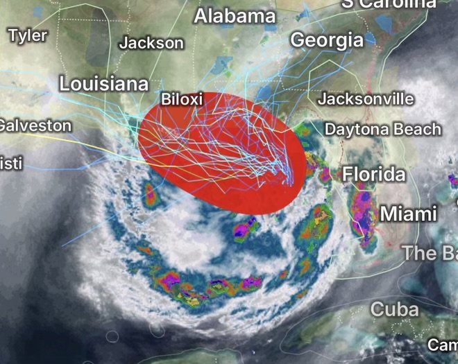
Although the latest Area of Interest (AOI) in the Atlantic has only a limited chance of becoming a tropical cyclone, it is already influencing weather conditions along portions of the Gulf Coast. Even weak tropical disturbances can transport deep tropical moisture inland, increasing the threat for heavy rainfall, thunderstorms, localized flooding, dangerous marine conditions, and hazardous beach conditions before any tropical development occurs. Recent National Hurricane Center outlooks indicate the disturbance has a modest chance of organization while moving near the northeastern Gulf and Florida Peninsula, with its greatest impacts expected to come from rainfall rather than strong winds.
Why This Area of Interest Matters
Many Gulf Coast residents focus on whether a system becomes a named storm. However, tropical disturbances frequently produce significant impacts without reaching tropical storm strength.
Current concerns include:
- Torrential tropical downpours
- Frequent lightning
- Localized flash flooding
- Gusty thunderstorms
- Rough surf
- Dangerous rip currents
- Reduced visibility for mariners
- Hazardous conditions for small boats
Forecast confidence continues to improve that tropical moisture will spread across portions of the eastern Gulf Coast regardless of whether tropical development occurs.
Coastal Cities Most Likely to Experience Elevated Weather
Communities along the eastern Gulf Coast should closely monitor changing forecasts.
Florida Gulf Coast
Areas most likely to experience periods of heavy rainfall include:
- Pensacola
- Panama City
- Apalachicola
- Port St. Joe
- Cedar Key
- Crystal River
- Tampa Bay
- Sarasota
- Fort Myers
Residents may experience:
- Slow-moving thunderstorms
- Heavy tropical rainfall
- Ponding on roadways
- Brief urban flooding
- Lightning hazards
Alabama
Communities including:
- Mobile
- Gulf Shores
- Orange Beach
may experience periods of heavy rain, isolated flooding, and rough marine conditions.
Mississippi
Areas including:
- Biloxi
- Gulfport
- Pascagoula
could see enhanced showers, gusty thunderstorms, and hazardous boating conditions.
Louisiana
While current forecasts suggest the greatest impacts remain farther east, southeastern Louisiana—including New Orleans and nearby coastal parishes—should continue monitoring forecast updates in case the disturbance shifts westward.
Elevated Marine Conditions Across the Gulf
Even without tropical cyclone formation, Gulf waters may experience:
- Increasing wave heights
- Frequent thunderstorms
- Sudden wind gusts
- Dangerous cloud-to-water lightning
- Reduced visibility in heavy rain
- Hazardous conditions for recreational boating
Small craft operators should monitor the latest marine forecasts before heading offshore.
Beach Hazards Expected
Beachgoers may notice worsening coastal conditions, including:
- Strong rip currents
- High surf
- Dangerous longshore currents
- Rough Gulf waters
- Dangerous swimming conditions near piers and jetties
Rip currents remain one of the deadliest coastal hazards during tropical weather events.
Flooding Risk
One of the largest concerns is excessive rainfall.
Slow-moving tropical rain bands can produce:
- Flash flooding
- Urban street flooding
- Overflowing drainage canals
- Flooded intersections
- Water-covered roadways
Flooding often occurs well away from the center of a tropical disturbance.
What Residents Should Do
Communities along the Gulf Coast should:
- Monitor forecasts from the National Hurricane Center and local National Weather Service offices.
- Never drive through flooded roads.
- Secure outdoor furniture before thunderstorms arrive.
- Have multiple ways to receive weather warnings.
- Avoid beaches during lightning or dangerous surf.
- Delay boating activities if thunderstorms are expected.
Looking Ahead
The Atlantic hurricane season is entering a more active period, and even weak Areas of Interest deserve close attention. While current forecasts indicate only gradual development is possible, the disturbance is already increasing rainfall and marine hazards across portions of the Gulf Coast. Tropical systems can evolve quickly, making it important for residents from Florida to Louisiana to remain weather-aware throughout the coming days.
Radar Watch HQ Top 5 Marine Essentials
Affiliate Disclosure: As an Amazon Associate, Radar Watch HQ earns from qualifying purchases.
🌊 1. U.S. Coast Guard-Approved Life Jacket
A properly fitted life jacket is the most important piece of safety equipment for every passenger onboard.
Best for: Recreational boaters, anglers, kayakers, and paddleboarders.
⚓ 2. Marine Emergency Radio (NOAA Weather Radio)
Receive real-time NOAA Weather Radio alerts, marine forecasts, and emergency warnings—even when cell service is unavailable.
Best for: Offshore and coastal boating.
🔦 3. Rechargeable Waterproof LED Flashlight
A bright waterproof flashlight is essential for emergencies, low visibility, nighttime navigation, and signaling for help.
Best for: Every boat emergency kit.
🧰 4. Marine First Aid Kit
A waterproof first aid kit stocked with bandages, antiseptic, medications, and emergency supplies for injuries on the water.
Best for: Every vessel, regardless of size.
🧭 5. Waterproof Dry Bag
Protect phones, wallets, charts, keys, electronics, and emergency supplies from water damage during storms or rough seas.
Best for: Boaters, kayakers, paddleboarders, and beachgoers.
🛒 Radar Watch HQ Marine Safety Picks
Prepare before you head out on the water. Our recommended marine safety essentials can help keep you and your crew safe during changing weather conditions.