Flash Flood Warning: Dangerous Heavy Rainfall Impacts Southwest Virginia and Southern West Virginia
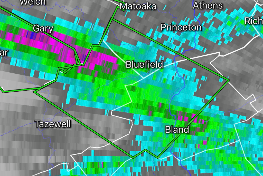
A Flash Flood Warning has been issued for Bland County, Virginia; Mercer County, West Virginia; and Tazewell County, Virginia as intense rainfall moves across the region. The National Weather Service warns that rainfall rates between 1.5 and 3 inches per hour may produce rapid flooding in vulnerable areas.
Residents across the warned area should prepare for quickly rising water, flooded roads, overflowing creeks, and hazardous travel conditions as heavy rain continues.
Areas at Risk for Flash Flooding
Communities in and around:
- Bland County, Virginia
- Tazewell County, Virginia
- Mercer County, West Virginia
may experience flash flooding, especially in:
- Low-lying areas
- Mountain valleys
- Small streams and creeks
- Poor drainage locations
- Roads near waterways
Southwest Virginia and southern West Virginia terrain can increase flood risks because steep slopes and narrow valleys allow runoff to rise quickly during intense rainfall events.
Rainfall Rates Create Dangerous Flood Setup
Rainfall rates of 1.5 to 3 inches in one hour can overwhelm drainage systems and rapidly increase water levels on roads and waterways. Similar heavy rainfall events in the region have produced flash flooding concerns across Bland, Mercer, and Tazewell counties.
Even areas that are not currently flooded can quickly become dangerous as additional rainfall moves through.
Flash Flood Safety: Turn Around, Don’t Drown
Never attempt to drive across flooded roads. Water depth can be difficult to judge, and moving water can sweep vehicles away.
Safety reminders:
- Avoid flooded roads and low-water crossings
- Move to higher ground if water begins rising nearby
- Keep children and pets away from floodwaters
- Monitor official weather alerts for updates
- Have emergency supplies ready if flooding impacts travel or power
Radar Watch HQ Weather Alert
Radar Watch HQ will continue monitoring this Flash Flood Warning across Bland VA, Mercer WV, and Tazewell VA as additional rainfall develops.
Stay connected for real-time severe weather updates, radar trends, and emergency preparedness information.
⚡ Radar Watch HQ Essential Pick
Portable Power When the Power Is Out. Stay Ready for Every Storm.
Power outages can happen with little warning during severe thunderstorms, tornadoes, hurricanes, winter storms, and other extreme weather events. A reliable portable power station can help keep your essential devices running, including phones, weather radios, medical equipment, lights, and other essential devices when you need them most.
At Radar Watch HQ, we recommend keeping emergency backup power as part of every severe weather preparedness plan. Having a portable power station on hand can provide added peace of mind and help you stay informed, connected, and prepared until power is restored.
Be storm-ready before the next warning is issued.
⚡ Shop Here: Portable Power Stations
Stay Powered When the Grid Goes Down.
Explore Radar Watch HQ’s recommended portable power stations for severe weather, power outages, camping, and emergency preparedness.
🛒 Shop Portable Power Stations
Affiliate Disclosure: Radar Watch HQ participates in the Amazon Associates Program, including Amazon Creator Connections. As an Amazon Associate, we may earn a commission from qualifying purchases made through links on this page, at no additional cost to you. Our recommendations are based on products we believe offer value for weather preparedness and emergency readiness.