Nueces River Flooding Continues to Impact South Texas
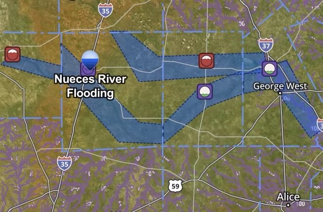
July 24, 2026 – Major flooding along the Nueces River continues to threaten communities across South Texas as floodwaters move downstream following days of intense rainfall. Although the heaviest rain has ended, river levels remain dangerously high, leading to ongoing Flood Warnings, road closures, evacuations, and hazardous travel conditions in several counties.
Emergency officials are urging residents to remain vigilant as floodwaters can continue rising even after skies clear. The slow movement of water through the river basin means flooding may persist for several more days in some locations.
Communities Experiencing Flood Impacts
Areas near Cotulla, Three Rivers, and portions of La Salle, Live Oak, McMullen, and surrounding counties remain under close monitoring as the Nueces River continues to run well above flood stage. Floodwaters have inundated low-lying areas, forced evacuations, and closed numerous secondary roads and low-water crossings.
Emergency responders have conducted water rescues while local officials continue encouraging residents in flood-prone areas to move to higher ground if instructed.
Why the River Is Still Rising
The flooding is being driven by runoff from widespread heavy rainfall that fell across South and Central Texas earlier this week. Even though precipitation has diminished, enormous volumes of water continue flowing downstream through the Nueces River system, causing delayed flooding far from where the heaviest rain originally occurred.
This type of river flooding often lasts much longer than flash flooding because water continues traveling through the watershed for days.
Ongoing Hazards
Residents should continue monitoring local forecasts because flood conditions can change quickly. Current hazards include:
- Flooded highways and county roads
- Washed-out low-water crossings
- Swift river currents
- Debris floating in floodwaters
- Isolated homes and neighborhoods
- Delayed emergency response due to inaccessible roads
Officials continue reminding motorists to Turn Around, Don’t Drown and never drive around barricades or into flooded roadways.
Safety Tips During River Flooding
If you live near the Nueces River:
- Stay informed through National Weather Service forecasts and local emergency management.
- Follow evacuation orders immediately if issued.
- Avoid flooded roads and bridges.
- Keep emergency supplies, medications, and important documents ready.
- Never allow children or pets near fast-moving floodwaters.
Looking Ahead
River forecasts indicate that portions of the Nueces River may remain above flood stage for several days while floodwaters gradually move downstream. Residents should continue monitoring official forecasts, especially those living near rivers, streams, and flood-prone roadways.
Stay with Radar Watch HQ for the latest flood updates, river forecasts, severe weather alerts, and emergency preparedness information across Texas and the United States.
Affiliate Disclosure: As an Amazon Associate, Radar Watch HQ earns from qualifying purchases.
Radar Watch HQ Top 5 Essential Emergency Preparedness Picks
Whether you’re preparing for severe thunderstorms, flash flooding, hurricanes, wildfires, or extended power outages, these five emergency essentials can help keep your household safer when severe weather strikes.
A portable power station provides reliable backup electricity during outages, allowing you to power phones, medical devices, laptops, lights, small appliances, and communication equipment without fuel.
Best for:
- Extended power outages
- Severe thunderstorms
- Hurricanes
- Winter storms
- Wildfires
2. Flood Protection Barriers & Sandless Flood Bags
Flood barriers help divert or absorb water before it enters garages, doorways, and low-lying areas. They deploy quickly and can help reduce property damage during flash flooding.
Best for:
- Flash Flood Warnings
- Heavy rainfall
- River flooding
- Coastal flooding
3. Rechargeable LED Flashlights
Bright, dependable flashlights are essential when the power goes out. Rechargeable or solar-powered models provide long-lasting illumination for navigating safely indoors and outdoors.
Best for:
- Overnight power outages
- Emergency evacuations
- Storm damage inspections
Keep phones, tablets, weather radios, and USB-powered devices charged when the electrical grid is unavailable. A solar power bank offers an additional charging option during prolonged emergencies.
Best for:
- Communication during outages
- Emergency weather alerts
- Travel and evacuation
A NOAA Weather Radio delivers official weather alerts directly from the National Weather Service, even when cellular networks or internet service are unavailable. It remains one of the most dependable ways to receive life-saving warnings.
Best for:
- Tornado warnings
- Severe thunderstorm warnings
- Flash flood warnings
- Hurricane alerts
- Winter storm emergencies
Why Radar Watch HQ Recommends These Essentials
At Radar Watch HQ, preparedness is just as important as staying informed. These five emergency essentials can help you stay connected, protect your property, and safely navigate severe weather events. Having supplies ready before storms arrive allows you to respond quickly when warnings are issued and conditions begin to deteriorate.