














Severe Thunderstorm Threat Expands Across the Northern Plains
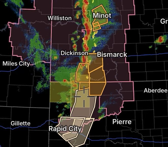
A significant round of severe thunderstorms is developing across portions of the Northern Plains this Sunday, August 30, 2026. Severe Thunderstorm Watches and Warnings are affecting areas of Montana, North Dakota, South Dakota and northeastern Wyoming, while additional communities are under Special Weather Statements.
The National Weather Service reports that severe storms could produce damaging wind gusts, large hail and locally heavy rainfall, with an isolated tornado threat also possible in some areas. The Bismarck forecast office has highlighted the potential for wind gusts reaching 70–75 mph and hail up to golf-ball or ping-pong-ball size in parts of its forecast area.
For residents and travelers across the affected region, conditions can change rapidly. A storm that is only being monitored can strengthen quickly, making it important to keep weather alerts enabled and know where to shelter.
Severe Thunderstorm Watch Covers Four States
A Severe Thunderstorm Watch is in effect across portions of far eastern Montana, western North Dakota, northwestern South Dakota and far northeastern Wyoming.
The active watch area includes portions of:
- Montana
- North Dakota
- South Dakota
- Wyoming
The National Weather Service Storm Prediction Center’s Severe Thunderstorm Watch 636 includes counties in eastern Montana, western North Dakota, western South Dakota and northeastern Wyoming. The watch was scheduled to remain in effect into the evening.
What the Watch Means
A Severe Thunderstorm Watch means atmospheric conditions are favorable for severe thunderstorms to develop or intensify.
It does not mean that every location inside the watch will experience severe weather. However, residents should be prepared to act quickly if a warning is issued.
The primary concerns include:
- Damaging straight-line winds
- Large hail
- Frequent lightning
- Heavy rainfall
- Localized flooding
- Isolated tornadoes
Additional Severe Thunderstorm Watch for North Dakota
Another Severe Thunderstorm Watch is affecting portions of central North Dakota and north-central South Dakota, adding another area of concern as storms develop and move through the region.
Severe Thunderstorm Watch 637 includes portions of North Dakota including Grant County and Sioux County, among other counties. The watch was issued for the afternoon and evening period.
The setup is particularly concerning because storms can organize into clusters or lines capable of producing widespread damaging wind gusts.
Severe Thunderstorm Warning: Minot and Surrounding Communities
A particularly dangerous situation is developing around Minot and north-central North Dakota, where a Severe Thunderstorm Warning has been issued for communities including:
- Minot
- Minot Air Force Base
- Burlington
- Surrey
- Glenburn
- Sawyer
- Lansford
- Des Lacs
- Carpio
- Foxholm
- Rice Lake
- Logan
- Grano
- Wolseth
Anyone in or near these communities should treat the warning as an immediate threat rather than simply monitoring the weather.
The broader Minot-area forecast has warned of severe thunderstorms capable of producing large hail, damaging wind gusts and a conditional isolated tornado threat, along with localized heavy rainfall.
Minot Area Storm Safety
If a warning is issued for your exact location:
- Move indoors immediately.
- Stay away from windows and exterior doors.
- Move to an interior room on the lowest safe floor.
- If a tornado warning is issued, use a basement or small interior room away from windows.
- Protect your head and neck if dangerous winds or debris become a concern.
- Avoid driving through areas experiencing heavy rain, hail or rapidly deteriorating visibility.
Severe Thunderstorm Warning for Grant and Sioux Counties
Another Severe Thunderstorm Warning is affecting Southern Grant County in south-central North Dakota and Southwestern Sioux County in south-central North Dakota.
These areas are included within the broader zone where severe storms are capable of producing damaging winds and large hail.
The National Weather Service has identified Grant County and Sioux County among the areas included in the current severe-weather environment.
Residents should monitor storm movement closely, particularly if thunderstorms begin to merge into larger clusters or lines.
Harding County Power Outage Adds Another Concern
Harding County, South Dakota, is also dealing with a power outage concern as severe weather moves across the region.
Power interruptions can become more likely when thunderstorms produce strong wind gusts, lightning and falling branches. Outages can also create secondary hazards, particularly when traffic signals, communications equipment or other infrastructure lose power.
If your electricity goes out:
- Keep flashlights readily available.
- Avoid downed power lines.
- Do not assume a fallen line is harmless because it is not sparking.
- Use battery-powered weather radios or devices when possible.
- Keep refrigerators and freezers closed as much as possible.
- Report outages through your utility provider.
- Have backup charging available for phones and essential devices.
Special Weather Statement Covers Parts of South Dakota
A Special Weather Statement is also highlighting a large area of western South Dakota, including:
Faith, Bison, Plainview, Meadow, Chance, Usta, Opal, Maurine, Date, Marcus, Iron Lightning, Red Owl, Stoneville, Red Elm, Howes, Glad Valley, Fairpoint, Arrowhead Buttes, Durkee Lake and Owen Lake.
These locations should continue monitoring the storm environment because a Special Weather Statement can precede the issuance of a more significant warning if storms strengthen or move into the area.
Special Weather Statements are generally used to communicate weather conditions that may not meet warning criteria but could still create hazards or become more significant.
Why These Storms Can Become Dangerous Quickly
The Northern Plains can experience rapid thunderstorm development when warm, unstable air interacts with strong atmospheric forcing.
Today’s forecast environment includes the potential for large hail and damaging winds, while localized heavy rainfall could occur beneath stronger storms.
Storms may also organize into lines or clusters. When that happens, the threat can transition from isolated severe storms to a broader damaging-wind event.
Additionally, heavy rainfall can temporarily overwhelm drainage systems and create dangerous conditions on roads.
What Residents Should Watch For
As storms move across the region, watch for:
Damaging Winds
Strong thunderstorm wind gusts can break tree limbs, damage roofs, overturn unsecured outdoor objects and cause power outages.
Large Hail
Large hail can damage vehicles, windows, roofs, crops and outdoor equipment within minutes.
Lightning
Lightning remains dangerous even when the storm’s strongest winds or hail are several miles away.
Heavy Rain
Thunderstorms can produce intense rainfall rates, resulting in rapidly reduced visibility and localized flooding.
Tornadoes
While not every storm will produce a tornado, the current forecast environment includes a conditional isolated tornado threat in parts of the region.
Travel Could Become Hazardous
Motorists across Montana, North Dakota, South Dakota and Wyoming should be prepared for rapidly changing conditions.
Heavy rain can make roads difficult to see, while hail can accumulate quickly. Strong crosswinds can also make driving difficult, especially for high-profile vehicles.
If visibility becomes severely reduced, slow down and seek a safe location rather than stopping beneath trees or near power lines.
Never drive through a flooded roadway. Water can conceal road damage and may be deeper or faster-moving than it appears.
Radar Watch HQ Safety Reminder
Severe weather warnings are location-specific and can change rapidly. A watch means conditions are favorable; a warning means severe weather is occurring or imminent in the warned area.
If you are inside a Severe Thunderstorm Warning, don’t wait for the storm to arrive before taking shelter.
Keep your phone charged, monitor weather alerts and have a safe indoor location ready.
National Weather Service provides official watches, warnings and forecasts for the affected areas.
Radar Watch HQ Final Thoughts
The Northern Plains are facing an active severe-weather period this August 30, with Severe Thunderstorm Watches spanning portions of Montana, North Dakota, South Dakota and Wyoming, while warnings are already affecting communities in North Dakota.
The combination of damaging winds, large hail, heavy rainfall, lightning and an isolated tornado threat means residents should remain weather-aware through the evening.
For those experiencing power outages, including areas of Harding County, preparation becomes even more important. Keep emergency lighting, phone chargers and essential supplies accessible, and stay away from downed electrical lines.
The most important rule tonight: if a Severe Thunderstorm or Tornado Warning is issued for your location, take action immediately.
Radar Watch HQ — Tracking the weather, explaining the threat, and helping communities stay weather-aware.

Affiliate Disclosure: As an Amazon Associate, Radar Watch HQ earns from qualifying purchases.
Radar Watch HQ Top 5 Essential Emergency Preparedness Picks
Whether you’re preparing for severe thunderstorms, flash flooding, hurricanes, wildfires, or extended power outages, these five emergency essentials can help keep your household safer when severe weather strikes.
A portable power station provides reliable backup electricity during outages, allowing you to power phones, medical devices, laptops, lights, small appliances, and communication equipment without fuel.
Best for:
- Extended power outages
- Severe thunderstorms
- Hurricanes
- Winter storms
- Wildfires
2. Flood Protection Barriers & Sandless Flood Bags
Flood barriers help divert or absorb water before it enters garages, doorways, and low-lying areas. They deploy quickly and can help reduce property damage during flash flooding.
Best for:
- Flash Flood Warnings
- Heavy rainfall
- River flooding
- Coastal flooding
3. Rechargeable LED Flashlights
Bright, dependable flashlights are essential when the power goes out. Rechargeable or solar-powered models provide long-lasting illumination for navigating safely indoors and outdoors.
Best for:
- Overnight power outages
- Emergency evacuations
- Storm damage inspections
Keep phones, tablets, weather radios, and USB-powered devices charged when the electrical grid is unavailable. A solar power bank offers an additional charging option during prolonged emergencies.
Best for:
- Communication during outages
- Emergency weather alerts
- Travel and evacuation
A NOAA Weather Radio delivers official weather alerts directly from the National Weather Service, even when cellular networks or internet service are unavailable. It remains one of the most dependable ways to receive life-saving warnings.
Best for:
- Tornado warnings
- Severe thunderstorm warnings
- Flash flood warnings
- Hurricane alerts
- Winter storm emergencies
Why Radar Watch HQ Recommends These Essentials
At Radar Watch HQ, preparedness is just as important as staying informed. These five emergency essentials can help you stay connected, protect your property, and safely navigate severe weather events. Having supplies ready before storms arrive allows you to respond quickly when warnings are issued and conditions begin to deteriorate.