Severe Thunderstorm Warning for Kidder and Stutsman Counties, North Dakota – Southeastern Wells County Warning Cancelled
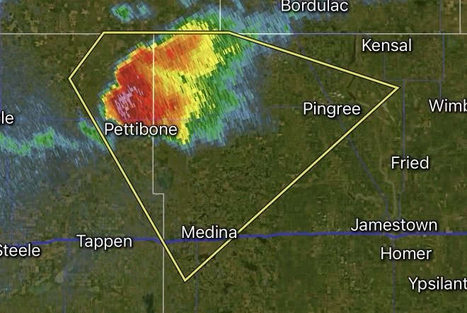
A Severe Thunderstorm Warning remains in effect for Kidder and Stutsman Counties in central North Dakota as strong thunderstorms continue to move across the region on July 24, 2026. Meanwhile, the Severe Thunderstorm Warning for southeastern Wells County has been cancelled after the storm weakened or moved out of the area.
The warned storms are capable of producing damaging wind gusts up to 60–70 mph, large hail, dangerous lightning, and torrential rainfall that may lead to localized flooding. Residents in the warning area should remain indoors and monitor the latest weather information as conditions can change rapidly.
Severe Weather Threat
The National Weather Service indicates that these thunderstorms may produce:
- Wind gusts capable of downing trees and power lines
- Large hail that can damage vehicles, roofs, and crops
- Frequent cloud-to-ground lightning
- Heavy rainfall that could reduce visibility and create ponding on roads
Southeastern Wells County Warning Cancelled
The cancellation of the warning for southeastern Wells County means the storm no longer poses a severe threat there. However, residents should continue to stay weather aware, as additional storms may develop later today and this evening.
Safety Tips During a Severe Thunderstorm Warning
- Move indoors immediately to a sturdy building.
- Stay away from windows and glass doors.
- Delay travel until storms have passed.
- Secure outdoor furniture and loose objects.
- Keep multiple ways to receive weather warnings, especially if power outages occur.
Strong to severe thunderstorms remain possible across parts of North Dakota through the evening, making it important to continue monitoring forecasts and official warnings for any updates.
Stay with Radar Watch HQ for the latest severe weather alerts, radar updates, and breaking forecast information across North Dakota and the United States.