South Florida Faces Dangerous Heat and Marine Weather
South Florida and portions of Central Florida are dealing with a combination of dangerous heat and unsettled marine conditions on August 12, 2026.
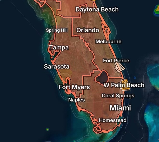
Heat Advisories are affecting all of South Florida, along with portions of southwest, west central, and east central Florida. At the same time, coastal waters along the Atlantic are experiencing marine weather alerts that could create hazardous conditions for boaters.
The combination creates two separate but important risks: heat-related illness on land and rapidly changing thunderstorm conditions on the water.
Heat Advisories Cover South Florida
A Heat Advisory is in effect across South Florida, where high temperatures combined with humidity can make outdoor conditions dangerous.
Additional Heat Advisories affect portions of:
- Southwest Florida
- West Central Florida
- East Central Florida
The Florida heat can feel significantly hotter than the actual thermometer reading because high humidity reduces the body’s ability to cool itself through evaporation.
Why the Heat Can Become Dangerous
Extended exposure to high heat can increase the risk of:
- Heat exhaustion
- Heat cramps
- Dehydration
- Dizziness and weakness
- Heat stroke
People spending time outdoors should take frequent breaks in air-conditioned or shaded locations and drink water regularly.
Children, older adults, outdoor workers, people exercising outdoors, and anyone without reliable access to air conditioning should take extra precautions.
Stay Ahead of the Afternoon Heat
The hottest portion of the day is generally when outdoor activities become most challenging.
Residents can reduce their exposure by scheduling strenuous activities during cooler portions of the day. Lightweight clothing, frequent hydration, and access to air conditioning can also help reduce heat stress.
Never leave children, older adults, or pets inside a parked vehicle. Interior temperatures can rise extremely quickly, even when windows are cracked.
Atlantic Coastal Waters Face Additional Hazards
The weather threat extends offshore.
A Special Marine Warning is affecting coastal waters from Jupiter Inlet to Deerfield Beach, Florida, out to 20 nautical miles.
A Special Marine Warning means dangerous conditions can develop quickly, particularly when thunderstorms move across coastal waters.
Boaters should be prepared to seek safe harbor or move to a protected location when threatening weather approaches.
Marine Weather Statement for Jupiter Inlet to Deerfield Beach
A Marine Weather Statement is also affecting the coastal waters from Jupiter Inlet to Deerfield Beach out to 20 nautical miles.
Marine weather can change quickly during Florida’s summer thunderstorm season. Even when skies appear relatively calm, storms can develop nearby and send strong winds, lightning, heavy rain, and rough seas across surrounding waters.
Boaters should continuously monitor weather information rather than relying solely on conditions observed at the dock.
Marine Weather Statement From Sebastian Inlet to Jupiter Inlet
Another Marine Weather Statement covers the coastal waters from Sebastian Inlet to Jupiter Inlet, 0 to 20 nautical miles.
This area can experience rapidly developing thunderstorms, especially during the afternoon and evening.
Lightning is one of the most significant dangers for anyone on the water. When thunderstorms approach, boaters should avoid remaining exposed on open water.
Thunderstorms Can Intensify Quickly
Florida’s warm, humid atmosphere provides plenty of energy for thunderstorms.
Storms can develop rapidly and produce:
- Frequent lightning
- Strong wind gusts
- Torrential rainfall
- Reduced visibility
- Rough or confused seas
- Dangerous boating conditions
A storm that appears distant can also become a threat quickly as it moves toward coastal waters.
Boating Safety During Marine Alerts
If you are already on the water, monitor marine alerts and weather conditions continuously.
Consider returning to port or moving into a safe harbor before thunderstorms reach your location. Do not wait until strong winds and heavy rain are already occurring.
Boaters should also ensure that communication equipment, navigation systems, life jackets, and emergency supplies are readily available.
If lightning is approaching, getting off the water and into a substantial enclosed shelter is the safest option.
Heat and Marine Weather Create a Double Threat
Today’s conditions demonstrate why Florida residents and visitors need to pay attention to both land and marine weather hazards.
The heat can create dangerous conditions for people outdoors, while thunderstorms can quickly turn otherwise manageable boating conditions into hazardous situations.
For anyone planning outdoor activities, beach trips, fishing, or boating, checking the latest weather information before leaving is essential.
What Residents and Visitors Should Remember
On land: Stay hydrated, limit prolonged exposure to extreme heat, take breaks in air conditioning, and watch for signs of heat illness.
On the water: Monitor marine alerts, watch developing thunderstorms, and be prepared to return to shore or seek shelter quickly.
Near the coast: Remember that thunderstorms can produce dangerous lightning and sudden wind changes even when rain is not immediately overhead.
Stay Weather Ready Across Florida
The combination of heat and marine weather hazards makes August 12, 2026, an important day for weather awareness across South and Central Florida.
Conditions can change quickly, particularly during the afternoon and evening thunderstorm period. Residents, visitors, and boaters should continue monitoring the latest local weather information and be ready to change plans when conditions deteriorate.
Stay informed. Stay hydrated. Watch the skies. And if you’re heading onto the water, don’t underestimate a developing Florida thunderstorm.
Stay Connected With Radar Watch HQ
Follow Radar Watch HQ for weather alerts, severe-weather updates, marine conditions, and important safety information. Stay weather-aware and share this update with family, friends, and anyone who may be traveling or boating across Florida today.

Radar Watch HQ Top 5 Essentials for Extreme Heat
Affiliate Disclosure: As an Amazon Associate, Radar Watch HQ earns from qualifying purchases.
When an Extreme Heat Watch or Heat Advisory is in effect, having the right gear can help you stay safer and more comfortable.
A compact, battery-powered fan provides cooling while traveling, working outdoors, waiting at events, or during power outages.
2. Insulated Water Bottle or Tumbler
A high-quality insulated bottle or cup keeps water cold for hours, making it easier to stay hydrated throughout the day.
A handheld misting fan or spray bottle delivers instant cooling by combining fine water mist with airflow.
Portable air conditioners, evaporative coolers (where appropriate), or high-performance tower fans can help reduce indoor temperatures during dangerous heat.
5. Electrolyte Hydration Packets or Drinks
Electrolyte supplements help replace minerals lost through heavy sweating and support hydration during prolonged heat exposure.