Severe Thunderstorms Meet Extreme Heat Across Northeast Florida
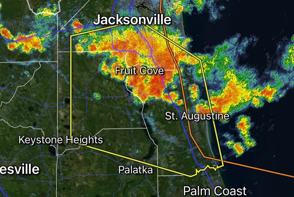
A Severe Thunderstorm Warning has been issued for portions of Clay, Duval, Putnam and St. Johns counties in Florida, bringing another round of dangerous weather to communities already dealing with intense summer heat.
When extreme heat and severe thunderstorms occur at the same time, residents face more than one hazard. Dangerous lightning, strong wind gusts, torrential rainfall and rapidly changing conditions can develop while temperatures and humidity remain oppressive.
For residents across Northeast Florida, this combination makes it especially important to take warnings seriously and move indoors quickly.
Why Heat Makes Severe Thunderstorms More Challenging
Florida’s summer heat can create an exhausting environment before a storm even arrives. High temperatures combined with humidity can increase heat stress, leaving people tired, dehydrated and more vulnerable to dangerous weather.
When thunderstorms develop, the sudden change in conditions can create additional risks.
Heavy rain may temporarily cool the air, but that does not mean the overall heat danger has disappeared. Once rainfall ends, humidity can remain high and temperatures can quickly become uncomfortable again.
People who have been outdoors for work, recreation or travel should take time to cool down and hydrate before and after storms.
Severe Thunderstorms Can Bring Multiple Hazards
A severe thunderstorm warning means residents should be prepared for potentially dangerous conditions.
Damaging Winds
Strong thunderstorm winds can knock down trees, damage structures and cause power outages.
Loose outdoor objects can also become dangerous projectiles. Before storms arrive, residents should secure items such as patio furniture, trash cans, decorations and other lightweight objects when it is safe to do so.
Dangerous Lightning
Lightning can strike well away from the strongest part of a thunderstorm.
The safest place during a thunderstorm is inside a substantial enclosed building or a hard-topped vehicle. Avoid open fields, beaches, pools and other exposed locations.
If you can hear thunder, you are close enough to be at risk from lightning.
Torrential Rain
Thunderstorms can produce intense rainfall in a short period of time. Poor drainage areas, streets and low-lying locations can flood quickly.
Never drive through a flooded roadway. Water depth can be difficult to judge, and moving water can sweep vehicles off the road.
Power Outages
Strong winds and lightning can damage electrical infrastructure and leave neighborhoods without power.
During an outage, extreme heat can become an additional concern, particularly for people who need reliable air conditioning or have limited access to a cool indoor location.
Heat and Power Outages Can Create a Dangerous Combination
One of the biggest concerns during summertime severe weather is the possibility of losing electricity while temperatures remain high.
Air conditioning may stop working, indoor temperatures can rise and humidity can make conditions increasingly uncomfortable.
Residents should have a plan for staying cool if the power goes out. Keep phones and backup batteries charged, have drinking water available and know where you can go to cool down if your home becomes too hot.
Do not use generators, grills or fuel-burning equipment inside a home, garage or other enclosed space because of the risk of carbon monoxide poisoning.
What Residents Should Do During the Warning
If you are inside when a severe thunderstorm warning is active, remain indoors and stay away from windows.
If you are outside, move into a substantial building as quickly as possible. Avoid trees, open areas, elevated locations and bodies of water.
If driving, slow down and be prepared for sudden heavy rain, reduced visibility, standing water and strong wind gusts.
Most importantly, do not wait until the storm is directly overhead to seek shelter.
After the Storm
The danger does not necessarily end when the warning expires.
Continue watching weather updates because additional thunderstorms may develop nearby. Stay away from downed power lines and report hazards to the appropriate local authorities or utility company.
Check on neighbors, family members and others who may need assistance, especially during prolonged heat and power outages.
Stay Weather-Ready in Clay, Duval, Putnam and St. Johns Counties
Severe thunderstorms can develop quickly across Northeast Florida, and the combination of extreme heat, high humidity and dangerous storms can place additional stress on residents and communities.
Keep weather alerts enabled, monitor trusted local weather information and know where you will shelter before the next warning is issued.
Radar Watch HQ Weather Safety Reminder
When a Severe Thunderstorm Warning is issued, take action. Get indoors, stay away from windows, avoid flooded roads and remain alert for additional warnings.
Stay Alert. Stay Cool. Stay Safe.
Weather conditions can change rapidly during Florida’s summer storm season. A hot afternoon can quickly turn into a dangerous thunderstorm environment.
Stay connected to Radar Watch HQ for weather alerts, severe storm updates and safety information. Share this article with family, friends and neighbors across Clay, Duval, Putnam and St. Johns counties so they know what to do when severe weather and extreme heat collide.

Affiliate Disclosure: As an Amazon Associate, Radar Watch HQ earns from qualifying purchases.
Radar Watch HQ Top 5 Essential Emergency Preparedness Picks
Whether you’re preparing for severe thunderstorms, flash flooding, hurricanes, wildfires, or extended power outages, these five emergency essentials can help keep your household safer when severe weather strikes.
A portable power station provides reliable backup electricity during outages, allowing you to power phones, medical devices, laptops, lights, small appliances, and communication equipment without fuel.
Best for:
- Extended power outages
- Severe thunderstorms
- Hurricanes
- Winter storms
- Wildfires
2. Flood Protection Barriers & Sandless Flood Bags
Flood barriers help divert or absorb water before it enters garages, doorways, and low-lying areas. They deploy quickly and can help reduce property damage during flash flooding.
Best for:
- Flash Flood Warnings
- Heavy rainfall
- River flooding
- Coastal flooding
3. Rechargeable LED Flashlights
Bright, dependable flashlights are essential when the power goes out. Rechargeable or solar-powered models provide long-lasting illumination for navigating safely indoors and outdoors.
Best for:
- Overnight power outages
- Emergency evacuations
- Storm damage inspections
Keep phones, tablets, weather radios, and USB-powered devices charged when the electrical grid is unavailable. A solar power bank offers an additional charging option during prolonged emergencies.
Best for:
- Communication during outages
- Emergency weather alerts
- Travel and evacuation
A NOAA Weather Radio delivers official weather alerts directly from the National Weather Service, even when cellular networks or internet service are unavailable. It remains one of the most dependable ways to receive life-saving warnings.
Best for:
- Tornado warnings
- Severe thunderstorm warnings
- Flash flood warnings
- Hurricane alerts
- Winter storm emergencies
Why Radar Watch HQ Recommends These Essentials
At Radar Watch HQ, preparedness is just as important as staying informed. These five emergency essentials can help you stay connected, protect your property, and safely navigate severe weather events. Having supplies ready before storms arrive allows you to respond quickly when warnings are issued and conditions begin to deteriorate.