Iselle Forms in the Eastern Pacific as Another Area of Development Emerges
Radar Watch HQ | August 23, 2026
Tropical Storm Iselle is now being monitored in the Eastern Pacific as the 2026 hurricane season continues to produce active tropical weather. According to the National Hurricane Center (NHC), Iselle is designated Tropical Storm Iselle (EP092026), with the first public advisory issued Sunday morning, August 23. (National Hurricane Center)
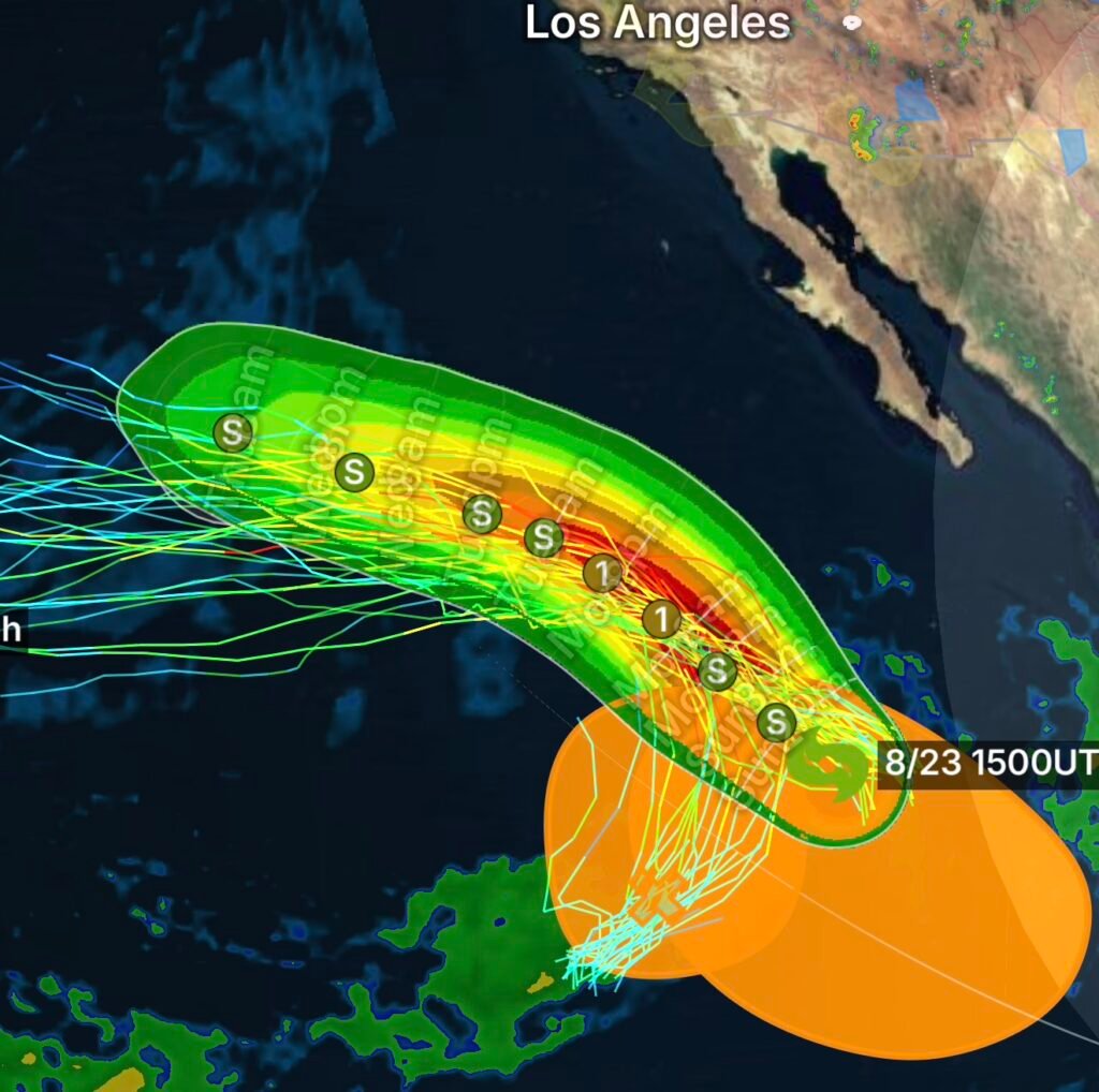
At the same time, forecasters are watching another area of low pressure expected to develop well south of the southern tip of the Baja California Peninsula during the middle portion of this week. Some slow development is possible afterward, and the system could organize into a tropical depression by the end of the week as it moves generally west-northwestward.
Tropical Storm Iselle: What We Know
The formation of Iselle adds another named system to an increasingly active period across the Eastern Pacific.
The National Hurricane Center’s Eastern Pacific outlook is the primary source for tracking tropical cyclone development, including potential tropical depressions, tropical storms and hurricanes. (National Hurricane Center)
For residents, boaters and travelers across the region, the most important factor right now is not simply the storm’s name, but how its circulation, thunderstorms, wind field and forecast track evolve over the coming days.
Tropical systems can strengthen or weaken rapidly when environmental conditions change. Therefore, early forecasts should be treated as a starting point rather than a guarantee of the eventual track or intensity.
Another Area of Interest South of Baja California
In addition to Iselle, meteorologists are monitoring another disturbance expected to develop during the middle of this week.
The area of low pressure is forecast to form well south of the southern tip of the Baja California Peninsula. Initially, development is expected to be slow. However, conditions could become more favorable for organization later in the week.
Forecasters indicate that a tropical depression could form by the end of the week.
The projected west-northwestward movement is also important because tropical disturbances can travel hundreds or even thousands of miles across the Eastern Pacific while changing intensity.
Why Slow Development Matters
Tropical cyclones require several ingredients to strengthen, including:
- Warm ocean water
- Sufficient atmospheric moisture
- Persistent thunderstorm activity
- Low to moderate vertical wind shear
- A developing, organized circulation
When these ingredients come together, thunderstorms can gradually consolidate around a low-pressure center. As the circulation becomes better organized, the system can progress from an area of disturbed weather to a tropical depression and potentially a tropical storm.
However, development is never guaranteed.
What Could Happen Next?
The new Eastern Pacific disturbance is still in the early stages of development, meaning there is considerable uncertainty regarding its eventual strength and track.
During the middle and latter portions of the week, forecasters will be watching for signs that the circulation is becoming more defined and that thunderstorms are becoming concentrated near the center.
If organization increases sufficiently, the National Hurricane Center could designate the system as a tropical depression.
From there, additional strengthening could result in a tropical storm.
For now, residents should avoid focusing on a specific long-range landfall scenario. At this stage, the system is far from having a reliable forecast for impacts.
Baja California and Pacific Interests Should Stay Weather-Aware
Although the developing disturbance is expected to remain well south of Baja California initially, conditions can change as tropical systems move across the Pacific.
Boaters and mariners should pay particular attention because tropical disturbances can produce:
- Increasing winds
- Higher seas
- Dangerous surf
- Heavy rain
- Reduced visibility
- Thunderstorms and lightning
Even systems that remain offshore can create hazardous marine conditions.
Eastern Pacific Tropical Weather Outlook
August is climatologically one of the more active portions of the Eastern Pacific hurricane season. As a result, multiple tropical disturbances can sometimes develop in relatively close succession.
That makes continued monitoring particularly important.
The National Hurricane Center currently provides Eastern Pacific tropical weather outlooks and updates as conditions evolve. (National Hurricane Center)
Radar Watch HQ will continue following Tropical Storm Iselle and the developing area of low pressure south of Baja California as new information becomes available.
Radar Watch HQ Final Thoughts
Tropical Storm Iselle is now an official tropical cyclone in the Eastern Pacific, while another potential system could emerge later this week south of Baja California.
The second disturbance is not yet a tropical depression, and significant uncertainty remains regarding its eventual development, intensity and track.
For now, the best approach is to monitor official forecasts rather than long-range speculation. Tropical systems can change quickly, and the forecast becomes more reliable as a circulation develops and additional observations become available.
Stay weather-aware, follow updates from the National Hurricane Center and local emergency officials, and check back with Radar Watch HQ for continuing tropical weather coverage.
Stay Ahead of the Weather
Follow Radar Watch HQ for the latest tropical weather developments, storm analysis, severe weather coverage and science-based explanations throughout the 2026 hurricane season.

Radar Watch HQ Top 5 Marine Essentials
Affiliate Disclosure: As an Amazon Associate, Radar Watch HQ earns from qualifying purchases.
🌊 1. U.S. Coast Guard-Approved Life Jacket
A properly fitted life jacket is the most important piece of safety equipment for every passenger onboard.
Best for: Recreational boaters, anglers, kayakers, and paddleboarders.
⚓ 2. Marine Emergency Radio (NOAA Weather Radio)
Receive real-time NOAA Weather Radio alerts, marine forecasts, and emergency warnings—even when cell service is unavailable.
Best for: Offshore and coastal boating.
🔦 3. Rechargeable Waterproof LED Flashlight
A bright waterproof flashlight is essential for emergencies, low visibility, nighttime navigation, and signaling for help.
Best for: Every boat emergency kit.
🧰 4. Marine First Aid Kit
A waterproof first aid kit stocked with bandages, antiseptic, medications, and emergency supplies for injuries on the water.
Best for: Every vessel, regardless of size.
🧭 5. Waterproof Dry Bag
Protect phones, wallets, charts, keys, electronics, and emergency supplies from water damage during storms or rough seas.
Best for: Boaters, kayakers, paddleboarders, and beachgoers.
🛒 Radar Watch HQ Marine Safety Picks
Prepare before you head out on the water. Our recommended marine safety essentials can help keep you and your crew safe during changing weather conditions.