Tropical Storm Moke Brings Another Round of Dangerous Weather to Hawaii
Tropical Storm Moke is bringing another significant weather threat to the Hawaiian Islands on Sunday, August 23, 2026, with the greatest concern focused on Hawaiʻi Island. Although Moke is expected to remain south of the islands rather than make a direct landfall, the storm is close enough to pull deep tropical moisture into the region.
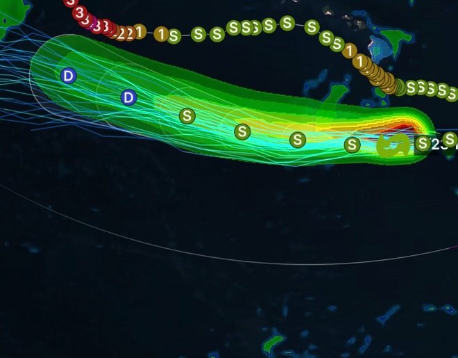
The Central Pacific Hurricane Center reports that Moke is producing maximum sustained winds around 45 mph, with higher gusts, while moving generally westward to west-northwestward south of the Big Island. (National Hurricane Center)
The biggest concern is not necessarily the storm’s wind intensity—it is the potential for life-threatening flooding and mudslides, particularly across areas that remain saturated and vulnerable after Hurricane Lala.
Where Tropical Storm Moke Is Having the Greatest Impact
Hawaiʻi Island Faces the Highest Flood Risk
Hawaiʻi Island is expected to experience the heaviest rainfall as Moke passes to the south.
Forecast rainfall totals include:
- 5 to 10 inches across portions of the Big Island
- Isolated totals up to 15 inches
- 3 to 6 inches possible across eastern Maui
- Lower rainfall totals across portions of the remaining islands
These rainfall amounts could produce dangerous flash flooding and mudslides, particularly across windward and southeastern portions of Hawaiʻi Island and steep terrain. (Hawaiʻi Department of Defense)
Because parts of the Big Island were recently impacted by Hurricane Lala, additional rainfall could quickly overwhelm drainage systems, streams and vulnerable slopes.
Why Moke’s Rainfall Is So Dangerous
Tropical storms can transport enormous amounts of moisture. As Moke passes south of Hawaii, its circulation is helping draw tropical moisture toward the islands.
When that moisture encounters the mountainous terrain of Hawaii, air is forced upward. This process can enhance rainfall, especially on windward slopes.
That means a storm does not have to make a direct landfall to create dangerous conditions.
In this case, saturated ground left behind by recent heavy rainfall makes the situation even more concerning. Additional rain can increase runoff, cause rivers and streams to rise rapidly, and destabilize hillsides.
Wind and Coastal Hazards
Although Moke is weaker than a hurricane, tropical-storm-force winds and higher gusts remain possible.
Exposed areas may experience:
- Gusty winds
- Downed branches
- Scattered power disruptions
- Difficult travel
- Rough surf
- Dangerous rip currents
- Reduced visibility in heavy rain
Swells generated by Moke are also expected to affect exposed east- and south-facing shores of the Hawaiian Islands during the next several days. (Hawaiʻi Department of Defense)
County-by-County Impact Breakdown
Hawaiʻi County
Highest concern: Heavy rainfall, flash flooding, mudslides and gusty winds.
Hawaiʻi County is expected to experience the greatest impacts from Moke. Heavy rainfall could be especially dangerous across windward and southeastern areas.
Residents in flood-prone locations should be prepared to move to a safer location before flooding begins.
Maui County
Primary concern: Heavy rainfall and localized flooding.
Eastern Maui could receive several inches of rain, with locally higher amounts possible. Steep terrain and areas with saturated soil could experience elevated runoff and localized flooding.
Honolulu County
Primary concern: Periods of rain, gusty winds and coastal hazards.
Oʻahu is expected to see less rainfall than Hawaiʻi Island, but tropical moisture associated with Moke can still produce periods of heavy rain and hazardous travel.
Kauaʻi County
Primary concern: Rain and localized impacts.
Kauaʻi is expected to remain farther from the center of Moke. However, moisture associated with the storm may still produce periods of rain, with locally heavier showers possible. (Kauai Now)
Moke and the Recent Hurricane Lala Recovery
The timing of Moke is particularly concerning because Hawaii is still recovering from Hurricane Lala.
Recent damage has left portions of the islands more vulnerable to additional rainfall, flooding and infrastructure problems. As a result, rainfall that might otherwise produce manageable impacts can become significantly more dangerous when soils are already saturated and drainage systems are compromised.
This is why residents should focus on rainfall and flooding impacts rather than simply the storm’s wind category.
Tropical Storm Moke Safety Tips
If you are in an area affected by Moke:
Avoid Flooded Roads
Never drive through flooded roadways. Water can be deeper and faster-moving than it appears, while roads and bridges can be damaged underneath the water.
Stay Away From Fast-Moving Water
Keep away from streams, drainage channels and normally dry waterways when heavy rain is occurring.
Watch for Mudslides
Residents near steep slopes should remain alert for signs of slope instability, including cracks in the ground, falling rocks, unusual water flows or sudden movement of soil.
Prepare for Power Outages
Charge phones and essential devices, keep flashlights available and make sure emergency supplies are accessible.
Follow Local Officials
Residents should monitor official updates from the National Weather Service, Central Pacific Hurricane Center, Hawaii Emergency Management Agency and local county emergency management agencies.
Tropical Storm Moke Outlook
Tropical Storm Moke is expected to continue moving generally westward to west-northwestward while passing south of the Hawaiian Islands. Gradual weakening is expected as the storm moves away, but its moisture can continue producing rainfall across portions of the island chain.
For Hawaii, the primary concern remains heavy rain and flooding rather than a direct tropical-storm landfall. (National Hurricane Center)
Radar Watch HQ Final Thoughts
Tropical Storm Moke is a reminder that tropical cyclone impacts extend well beyond the center of a storm.
Even while remaining offshore, Moke can deliver dangerous rainfall, gusty winds, rough surf and flooding. With portions of Hawaii still recovering from Hurricane Lala, residents should take the flood threat seriously and remain prepared for rapidly changing conditions.
Stay weather aware, avoid flooded areas, and continue monitoring official forecasts as Moke moves past the Hawaiian Islands.
Radar Watch HQ will continue tracking Tropical Storm Moke and the latest tropical weather developments.