Strong Northwest Winds and Building Seas Create Hazardous Conditions Offshore
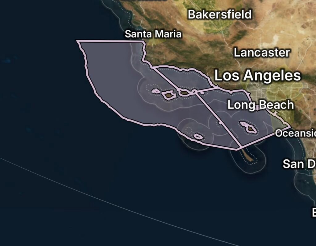
Southern California’s offshore waters are facing hazardous marine conditions as a Small Craft Advisory remains in effect through Monday morning, August 17. The advisory covers waters from Point Sal to Santa Cruz Island and westward 60 nautical miles, including San Miguel and Santa Rosa Islands, as well as the outer waters from Santa Cruz Island to San Clemente Island, extending 60 nautical miles offshore, including San Nicolas and Santa Barbara Islands. (National Weather Service)
For mariners, the combination of strong northwest winds, elevated seas and periods of fog can make navigation more difficult, particularly for smaller and less-experienced vessels.
What Conditions Are Expected Offshore?
According to the National Weather Service Los Angeles/Oxnard marine forecast, the northern offshore zone is experiencing northwest winds around 15 to 20 knots, with gusts up to 25 knots, and seas around 4 to 6 feet today. Tonight, winds are expected to increase to 20 to 25 knots, with seas remaining around 5 to 6 feet. (National Weather Service)
Patchy fog may also develop, reducing visibility and adding another challenge for boat operators.
Conditions May Become Rougher
The marine pattern is expected to remain active beyond Sunday. Forecast guidance indicates northwest winds could remain around 20 to 25 knots Monday, with stronger winds and higher seas possible later in the week across portions of the offshore waters. (Marine Weather)
Because conditions can vary significantly across the large advisory area, mariners should monitor the latest coastal waters forecast before departing and continue checking conditions while underway.
Areas Covered by the Small Craft Advisory
Point Sal to Santa Cruz Island
The advisory includes waters extending westward up to 60 nautical miles from Point Sal to Santa Cruz Island.
This includes waters surrounding or near:
- Point Sal
- Santa Cruz Island
- San Miguel Island
- Santa Rosa Island
- Offshore waters extending up to 60 nautical miles
These exposed waters can experience stronger northwest winds and more challenging wave conditions than sheltered coastal locations.
Santa Cruz Island to San Clemente Island
The second advisory area extends from Santa Cruz Island southward toward San Clemente Island, reaching up to 60 nautical miles offshore.
The zone includes offshore waters near:
- Santa Cruz Island
- Santa Barbara Island
- San Nicolas Island
- San Clemente Island
- Southern California outer waters
The broad offshore area means conditions can change quickly as vessels move farther from the coastline.
Why Northwest Winds Matter for Small Boats
Northwest winds are a common marine hazard along portions of the Southern California coast. When winds increase over the ocean, they can generate short-period wind waves that make the sea surface choppier and more uncomfortable.
The current forecast calls for northwest winds of 15 to 25 knots in portions of the advisory area, with seas reaching several feet and becoming more challenging during stronger wind periods. (National Weather Service)
For smaller vessels, these conditions can lead to:
- Difficult handling
- Increased spray
- Reduced comfort and stability
- Greater risk when traveling across or into waves
- More challenging docking and maneuvering
- Increased fuel consumption
- Reduced visibility when fog develops
San Miguel and Santa Rosa Islands
The waters around San Miguel and Santa Rosa Islands are particularly exposed to Pacific winds because of their position within the Channel Islands.
San Miguel Island is the westernmost of California’s Channel Islands, making surrounding waters especially vulnerable to stronger open-ocean conditions. (Wikipedia)
Boaters traveling between the mainland and the northern Channel Islands should account for the possibility of stronger winds and changing seas rather than relying solely on conditions observed near shore.
San Nicolas, Santa Barbara and San Clemente Island Waters
Farther south, the advisory encompasses offshore waters near San Nicolas Island, Santa Barbara Island and San Clemente Island.
These areas are also exposed to Pacific swell and wind-driven seas. San Clemente Island, located at the southern end of the Channel Islands, is surrounded by extensive offshore waters where marine conditions can differ considerably from those closer to the mainland. (Wikipedia)
Who Could Be Most Impacted?
The advisory is particularly important for:
- Small recreational boats
- Fishing vessels
- Kayakers and paddlecraft operating offshore
- Sailboats
- Charter boats
- Commercial operators using smaller vessels
- Divers and other offshore recreational users
Inexperienced mariners and operators of smaller vessels should consider postponing offshore travel while hazardous conditions persist. (Weather Alert Watch)
Marine Safety Tips
Before heading offshore, mariners should:
- Check the latest marine forecast and advisory information.
- Confirm that navigation, communication and safety equipment are working.
- Secure loose equipment and cargo.
- Wear a properly fitted life jacket while underway.
- File a float plan with someone on shore.
- Monitor changing winds, waves and visibility.
- Avoid unnecessary offshore travel if conditions exceed the vessel’s capabilities.
- Be especially cautious around stronger wind periods and during reduced visibility.
Don’t Rely Only on Nearshore Conditions
One of the biggest concerns with a large offshore advisory area is that conditions at the harbor or beach may not represent conditions several miles offshore.
The National Weather Service specifically advises mariners to consider weather over a larger area because conditions at an individual forecast point may not fully represent the conditions across the marine zone. (National Weather Service)
Radar Watch HQ Weather Takeaway
The Small Craft Advisory along Southern California waters is a reminder that summer ocean conditions can still become hazardous for smaller vessels. Strong northwest winds, elevated seas and periods of fog can combine to create difficult offshore conditions from the waters near Point Sal and the northern Channel Islands all the way toward San Clemente Island.
While the advisory is currently scheduled through Monday morning, August 17, mariners should continue monitoring updated forecasts because wind and wave conditions can change rapidly across the offshore zones. (National Weather Service)
Stay weather-aware, know your vessel’s limits, and make safety the first part of every offshore trip. Follow Radar Watch HQ for continuing weather coverage, marine conditions and severe-weather updates.

Radar Watch HQ Top 5 Marine Essentials
Affiliate Disclosure: As an Amazon Associate, Radar Watch HQ earns from qualifying purchases.
🌊 1. U.S. Coast Guard-Approved Life Jacket
A properly fitted life jacket is the most important piece of safety equipment for every passenger onboard.
Best for: Recreational boaters, anglers, kayakers, and paddleboarders.
⚓ 2. Marine Emergency Radio (NOAA Weather Radio)
Receive real-time NOAA Weather Radio alerts, marine forecasts, and emergency warnings—even when cell service is unavailable.
Best for: Offshore and coastal boating.
🔦 3. Rechargeable Waterproof LED Flashlight
A bright waterproof flashlight is essential for emergencies, low visibility, nighttime navigation, and signaling for help.
Best for: Every boat emergency kit.
🧰 4. Marine First Aid Kit
A waterproof first aid kit stocked with bandages, antiseptic, medications, and emergency supplies for injuries on the water.
Best for: Every vessel, regardless of size.
🧭 5. Waterproof Dry Bag
Protect phones, wallets, charts, keys, electronics, and emergency supplies from water damage during storms or rough seas.
Best for: Boaters, kayakers, paddleboarders, and beachgoers.
🛒 Radar Watch HQ Marine Safety Picks
Prepare before you head out on the water. Our recommended marine safety essentials can help keep you and your crew safe during changing weather conditions.