Dangerous Storms Target North Carolina Coastal Waters
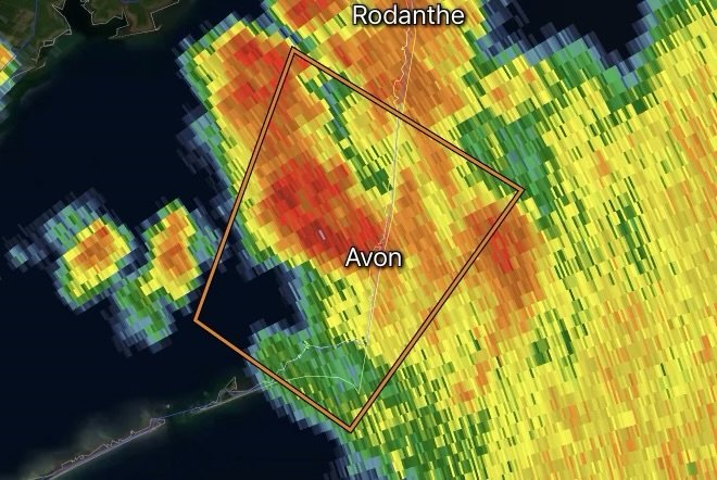
August 3, 2026 – A Special Marine Warning has been issued for portions of the North Carolina coast as strong thunderstorms move across Pamlico Sound, the Atlantic waters south of Cape Hatteras to Ocracoke Inlet out to 20 nautical miles, and the waters south of Oregon Inlet to Cape Hatteras out to 20 nautical miles.
These storms are capable of producing dangerous conditions for anyone on the water. Boaters should be prepared for sudden wind shifts, rough seas, intense lightning, torrential rainfall, and significantly reduced visibility.
Areas Included in the Warning
The warning includes:
- Pamlico Sound
- Atlantic waters south of Cape Hatteras to Ocracoke Inlet out to 20 nautical miles
- Atlantic waters south of Oregon Inlet to Cape Hatteras out to 20 nautical miles
These waters are popular with commercial fishermen, recreational boaters, charter fishing vessels, and beachgoers, making rapidly developing storms especially hazardous.
Expected Marine Hazards
Strong thunderstorms over the coastal waters may produce:
- Wind gusts capable of creating hazardous wave conditions
- Frequent cloud-to-water lightning
- Heavy rainfall reducing visibility
- Choppy to rough seas
- Sudden wind direction changes
- Dangerous conditions for smaller vessels
Even storms that appear relatively small on radar can quickly intensify over warm coastal waters and produce life-threatening marine conditions.
Safety Tips for Mariners
Anyone on the water should take immediate action if storms approach.
- Head to the nearest safe harbor immediately.
- Monitor NOAA Weather Radio and marine weather updates.
- Secure loose equipment before strong winds arrive.
- Avoid open water during lightning.
- Wear a properly fitted U.S. Coast Guard-approved life jacket.
- Never attempt to outrun severe thunderstorms across open water if safe harbor is nearby.
Storms Can Develop Quickly Along the Outer Banks
During the summer, sea breeze boundaries, abundant moisture, and daytime heating frequently trigger fast-moving thunderstorms across eastern North Carolina. These storms can strengthen rapidly as they move across Pamlico Sound and adjacent Atlantic waters, creating dangerous conditions with little warning.
Mariners should continue monitoring weather conditions throughout the evening, as additional thunderstorms may develop while warm, humid air remains in place.
Stay connected with Radar Watch HQ for the latest marine warnings, severe weather updates, coastal radar, and breaking forecasts affecting the Carolinas and the entire U.S. coastline. Always check the latest marine forecast before heading onto the water, and never underestimate rapidly developing thunderstorms.
Radar Watch HQ Top 5 Marine Essentials
Affiliate Disclosure: As an Amazon Associate, Radar Watch HQ earns from qualifying purchases.
🌊 1. U.S. Coast Guard-Approved Life Jacket
A properly fitted life jacket is the most important piece of safety equipment for every passenger onboard.
Best for: Recreational boaters, anglers, kayakers, and paddleboarders.
⚓ 2. Marine Emergency Radio (NOAA Weather Radio)
Receive real-time NOAA Weather Radio alerts, marine forecasts, and emergency warnings—even when cell service is unavailable.
Best for: Offshore and coastal boating.
🔦 3. Rechargeable Waterproof LED Flashlight
A bright waterproof flashlight is essential for emergencies, low visibility, nighttime navigation, and signaling for help.
Best for: Every boat emergency kit.
🧰 4. Marine First Aid Kit
A waterproof first aid kit stocked with bandages, antiseptic, medications, and emergency supplies for injuries on the water.
Best for: Every vessel, regardless of size.
🧭 5. Waterproof Dry Bag
Protect phones, wallets, charts, keys, electronics, and emergency supplies from water damage during storms or rough seas.
Best for: Boaters, kayakers, paddleboarders, and beachgoers.
🛒 Radar Watch HQ Marine Safety Picks
Prepare before you head out on the water. Our recommended marine safety essentials can help keep you and your crew safe during changing weather conditions.