Wyoming Fire Weather & Freeze Threat
Wyoming is facing a sharp contrast in weather hazards on Tuesday, September 8, 2026. Red Flag Warnings are in effect across portions of central, north-central and southeastern Wyoming, while a Fire Weather Watch covers additional areas of southwest and west-central Wyoming. At the same time, a Freeze Warning is set to bring the first significant freeze threat to parts of western Wyoming early Wednesday morning.
The combination of low humidity, gusty winds and dry fuels is creating conditions capable of supporting rapid wildfire growth. Meanwhile, temperatures are expected to fall below freezing in several western Wyoming valleys overnight. (National Weather Service)
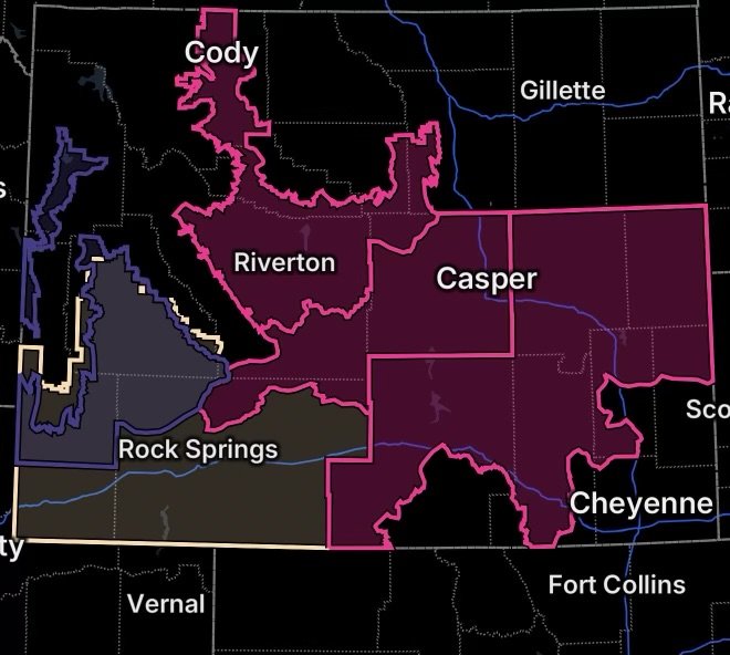
Red Flag Warnings Cover Much of Wyoming
A Red Flag Warning means critical fire-weather conditions are occurring or are expected shortly. When strong winds combine with very low humidity and dry vegetation, even a small ignition can grow rapidly.
Southeastern and Central Wyoming
The National Weather Service in Cheyenne has a Red Flag Warning in effect from noon to 8 p.m. MDT Tuesday for Fire Weather Zones 417, 418, 419, 420, 421, 422 and 427.
These zones include portions of:
- Niobrara and lower elevations of Converse County
- Thunder Basin National Grassland
- The Middle North Platte River Basin
- Niobrara and Converse high plains
- North Laramie Range and adjacent high plains
- North Laramie Valley and Shirley Basin
- Ferris, Seminoe and Shirley Mountains
- Central and western Carbon County
- North Snowy Range foothills
Westerly winds are expected to gust as high as 35 mph, while relative humidity falls to approximately 10% to 15%. The combination creates a dangerous environment for rapid fire spread. Outdoor burning is not recommended. (National Weather Service)
Central Wyoming
Farther west, another Red Flag Warning covers Fire Weather Zones 280, 289 and 300 from noon Tuesday through 9 p.m. MDT Thursday.
The affected areas include portions of central Wyoming, including the Natrona County/Casper area, Granite, Green, Ferris and Rattlesnake Mountains, and Casper Mountain.
The National Weather Service expects west to southwest winds of 15 to 25 mph with gusts up to 35 mph Tuesday, while humidity drops as low as 11% to 18%. Even drier conditions are possible Wednesday and Thursday, with minimum humidity potentially falling into the single digits. (National Weather Service)
North-Central and Central Wyoming
Another Red Flag Warning is in effect from noon to 7 p.m. MDT Tuesday for Fire Weather Zones 276, 283, 285 and 287.
The affected areas include the Cody Foothills, Upper Wind River Basin, South Bighorn Mountains and Owl Creek Mountains.
Winds are forecast to reach 10 to 20 mph with gusts up to 30 mph, while humidity ranges from approximately 12% to 19%. A cold front moving southward through northern Wyoming will also shift winds, potentially producing erratic fire behavior. (National Weather Service)
Why Today’s Fire Threat Is Significant
Several ingredients are coming together across Wyoming.
Low Humidity
Dry air allows vegetation to lose moisture quickly. When grasses, brush and other fine fuels become critically dry, they can ignite and burn much more efficiently.
Strong and Gusty Winds
Wind is one of the most important factors in wildfire growth. It can rapidly spread flames, carry embers ahead of the main fire and make suppression more difficult.
Wind Shift From a Cold Front
The approaching cold front adds another concern. As winds turn more northerly behind the front, changing wind direction can cause a fire to shift direction unexpectedly. (National Weather Service)
Fire Weather Watch Expands the Concern
Additional portions of Wyoming are under a Fire Weather Watch, including southwest Wyoming Fire Weather Zones 277 and 279 and west-central Wyoming Fire Weather Zone 278.
Forecast conditions include strong southwest winds, with gusts potentially reaching 40 mph, alongside very low humidity. (National Weather Service)
A Fire Weather Watch means conditions could become favorable for critical fire weather. Residents, land managers and outdoor recreationists should monitor later forecasts because a watch can be upgraded to a Red Flag Warning when confidence increases.
Freeze Warning for Western Wyoming
While wildfire danger dominates much of the state, western Wyoming is preparing for a dramatically different hazard.
The National Weather Service has issued a Freeze Warning from 2 a.m. to 9 a.m. MDT Wednesday, September 9, for:
- Jackson Hole
- South Lincoln
- Star Valley
- Upper Green River Basin
- Upper Green River Basin Foothills
Temperatures are expected to fall to 26°F to 32°F, with isolated cold spots potentially dropping to 22°F to 25°F. (National Weather Service)
Potential Freeze Impacts
The cold could damage or kill sensitive plants and crops. Unprotected outdoor plumbing may also be vulnerable to freezing temperatures.
Residents should bring sensitive plants indoors or cover them before temperatures fall. Outdoor plumbing and irrigation equipment should also be protected where possible.
Fire Safety: What Wyoming Residents Should Do
During a Red Flag Warning, residents should take wildfire prevention seriously.
Avoid Outdoor Burning
Postpone campfires, brush burning, debris burning and other activities involving open flames. Even a small ember can ignite dry vegetation when winds are strong.
Secure Potential Ignition Sources
Make sure cigarette butts, matches and other combustible materials are completely extinguished and properly disposed of.
Use Extra Caution With Vehicles
Avoid parking vehicles over dry grass whenever possible. Hot exhaust components can ignite vegetation.
Prepare for Rapid Fire Growth
People living near wildlands should know multiple evacuation routes and monitor official emergency information. If an evacuation order is issued, leave promptly.
A Sharp Weather Contrast Across Wyoming
Tuesday’s weather pattern demonstrates how quickly conditions can vary across Wyoming.
Central and eastern portions of the state are dealing with dry air and strong winds that increase wildfire potential, while western valleys are preparing for sub-freezing temperatures early Wednesday.
The National Weather Service’s latest fire-weather forecast shows dry conditions continuing across many western and central Wyoming areas, with gusty winds becoming widespread before a cold front moves through. (National Weather Service)
Radar Watch HQ Final Thoughts
Wyoming residents should take today’s fire-weather conditions seriously, particularly in areas covered by Red Flag Warnings. Low humidity, dry fuels and strong winds can allow a wildfire to spread rapidly and behave unpredictably.
At the same time, western Wyoming residents should prepare for the overnight freeze, especially anyone protecting gardens, crops, livestock or outdoor plumbing.
Weather conditions can change quickly across the state’s mountains, valleys and high plains. Continue monitoring official forecasts and local emergency information throughout the day.
Preparedness Essentials
For wildfire-prone areas, keep emergency supplies, important documents, medications, chargers and other necessities ready to go. Residents should also maintain multiple ways to receive emergency notifications.