Cottonwood Burn Scar Triggers Flash Flooding and Dangerous Debris Flows in Piute and Beaver Counties, Utah
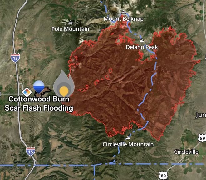
A dangerous wave of post-wildfire weather is threatening central and southern Utah. Following the massive Cottonwood Fire—which charred tens of thousands of acres across Beaver and Piute counties—intense seasonal rainfall has created a secondary crisis: catastrophic flash flooding and aggressive debris flows.
Emergency management officials, local authorities, and state agencies are on high alert as these fast-moving natural hazards endanger rural communities, wash out vital infrastructure, and prompt urgent safety warnings.
Fast Facts: Cottonwood Burn Scar Flooding & Debris Flows
Impacted Regions: Beaver and Piute counties, Utah, with high-risk zones stretching downstream from the Cottonwood Fire burn scar, including North Creek and the Grove neighborhood areas in Beaver.
Primary Threat: Extreme, fast-moving debris flows—a destructive slurry of heavy mud, ash, rocks, and uprooted trees tearing down canyons and river corridors.
Infrastructure Damage: Major disruptions along State Route 153 (Beaver Canyon Scenic Byway) due to road washouts and undercutting, alongside potential threats to local culinary and agricultural water systems.
Official Response: Emergency declarations and local evacuation protocols have been enacted to protect residents in the direct path of potential floodwaters.
Action Required: Heed local evacuation notices (“Go” status) immediately, avoid traveling through canyons or near waterways during heavy rain, and monitor real-time National Weather Service (NWS) flash flood warnings.
The Science of the Threat: Why Burn Scars Produce Severe Debris Flows
When a major wildfire sweeps through a landscape, it destroys the vegetation that typically anchors soil and absorbs moisture. More critically, intense fire heat bakes organic compounds into the earth, creating a waxy, water-repellent layer just beneath the surface (hydrophobic soil).
When heavy summer rain falls over these denuded slopes in Piute and Beaver counties, the ground cannot absorb the water. Instead, 100% of the precipitation transforms into instant surface runoff. As this water races down steep mountain channels, it strips away loose ash, dirt, and boulders, transforming ordinary rain runoff into a heavy, high-momentum debris flow that acts more like a moving wall of wet concrete than standard floodwater.
Community Impacts Across Beaver and Piute Counties
The environmental fallout from the Cottonwood Burn Scar is causing widespread disruption for residents and travelers:
Mountain Road Washouts and Closures: Scenic corridors and key mountain routes, such as State Route 153 through Beaver Canyon, face severe hazards. Flash floods can quickly erode roadbeds, wash out culverts, and undercut asphalt, leaving routes impassable.
Threats to Downstream Communities: Neighborhoods situated near canyon mouths, creeks, and the Beaver River—including the Grove area and North Creek—sit directly in the path of sudden mountain runoff.
Strained Utilities: Debris-laden torrents can clog or damage local water intakes, irrigation ditches, and utility lines, posing a risk to municipal and agricultural resources.
Flash Flood Safety Checklist: Protecting Yourself and Your Family
Post-wildfire flash floods develop with terrifying speed, sometimes arriving minutes after rain begins miles away. If you live near or are traveling through Piute and Beaver counties during active weather alerts, keep these crucial safety rules in mind:
Heed Evacuation Orders Instantly: If local authorities or emergency management issue a “Go” evacuation order for your neighborhood, leave immediately. Do not delay; fast-moving debris flows block escape routes quickly.
Stay Away from Canyons and Waterways: Creeks, rivers, and dry washes originating from the Cottonwood Burn Scar can swell violently during downpours. Maintain a safe distance from banks and steep channels.
Turn Around, Don’t Drown: Never drive or walk through flooded roadways. Just a few inches of fast-moving mud and water can sweep away a vehicle or hide deeply eroded, washed-out road surfaces beneath.
Monitor Official Weather Channels: Keep a NOAA Weather Radio close by and sign up for local county emergency alerts. Weather conditions and flash flood risks over burn scars can change within minutes.
Affiliate Disclosure: As an Amazon Associate, Radar Watch HQ earns from qualifying purchases.
Radar Watch HQ Top 5 Essential Emergency Preparedness Picks
Whether you’re preparing for severe thunderstorms, flash flooding, hurricanes, wildfires, or extended power outages, these five emergency essentials can help keep your household safer when severe weather strikes.
A portable power station provides reliable backup electricity during outages, allowing you to power phones, medical devices, laptops, lights, small appliances, and communication equipment without fuel.
Best for:
- Extended power outages
- Severe thunderstorms
- Hurricanes
- Winter storms
- Wildfires
2. Flood Protection Barriers & Sandless Flood Bags
Flood barriers help divert or absorb water before it enters garages, doorways, and low-lying areas. They deploy quickly and can help reduce property damage during flash flooding.
Best for:
- Flash Flood Warnings
- Heavy rainfall
- River flooding
- Coastal flooding
3. Rechargeable LED Flashlights
Bright, dependable flashlights are essential when the power goes out. Rechargeable or solar-powered models provide long-lasting illumination for navigating safely indoors and outdoors.
Best for:
- Overnight power outages
- Emergency evacuations
- Storm damage inspections
Keep phones, tablets, weather radios, and USB-powered devices charged when the electrical grid is unavailable. A solar power bank offers an additional charging option during prolonged emergencies.
Best for:
- Communication during outages
- Emergency weather alerts
- Travel and evacuation
A NOAA Weather Radio delivers official weather alerts directly from the National Weather Service, even when cellular networks or internet service are unavailable. It remains one of the most dependable ways to receive life-saving warnings.
Best for:
- Tornado warnings
- Severe thunderstorm warnings
- Flash flood warnings
- Hurricane alerts
- Winter storm emergencies
Why Radar Watch HQ Recommends These Essentials
At Radar Watch HQ, preparedness is just as important as staying informed. These five emergency essentials can help you stay connected, protect your property, and safely navigate severe weather events. Having supplies ready before storms arrive allows you to respond quickly when warnings are issued and conditions begin to deteriorate.