


Coleman Creek & Hat Fires Strike Oregon: Evacuations & Acres Burned
A severe wildfire outbreak is threatening southeastern Oregon, forcing emergency evacuations and scorching hundreds of thousands of acres. Two major incidents—the massive Coleman Creek Fire and the Hat Fire—are actively challenging firefighting resources across Malheur and Harney counties. Residents in the path of these blazes face immediate threats, prompting urgent warnings and mandatory safety protocols from local emergency management.
Fast Facts: Oregon Wildfire Updates
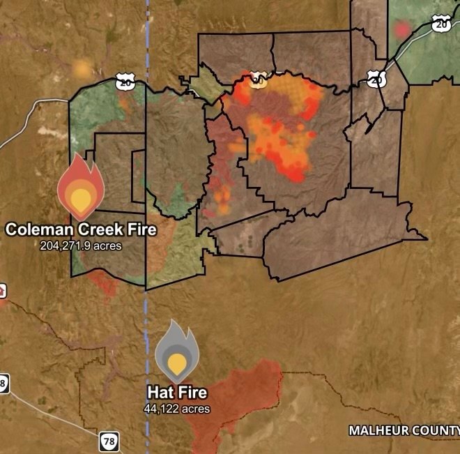
Coleman Creek Fire Size: Estimated at a massive 204,271 acres spanning across portions of Malheur and Harney counties.
Hat Fire Size: Reached 44,122 acres within Malheur County, Oregon.
Current Status: Active evacuation orders are in place for zones directly threatened by fire progression and heavy smoke.
Core Hazards: Rapid fire spread driven by dry fuels and erratic winds, severe smoke impacting regional air quality, and compromised infrastructure.
Action Required: Obey local evacuation orders immediately, avoid fire zones, and monitor official emergency channels for real-entime updates.
Coleman Creek Fire Explodes Across Malheur and Harney Counties
The Coleman Creek Fire has demonstrated extreme explosive growth, charring a staggering 204,271 acres across Malheur and Harney counties. Stagnant dry conditions, high afternoon temperatures, and gusty winds have fueled aggressive fire behavior, making containment efforts extremely difficult for ground and air crews.
Evacuation Orders: Authorities have issued strict evacuation orders for residents in designated threatened zones. Staying behind in these areas puts lives at extreme risk and hinders emergency response teams.
Smoke Impacts: Thick plumes of smoke are choking the surrounding countryside, severely degrading local air quality and reducing visibility on regional highways.
Hat Fire Burns 44,122 Acres in Malheur County
Adding to the regional crisis, the Hat Fire is actively burning in Malheur County, Oregon. Having already scorched 44,122 acres, the fire continues to threaten remote range lands, local infrastructure, and wildlife habitats. Firefighters are utilizing heavy equipment and aerial support to establish control lines, but erratic wind shifts remain a persistent obstacle.
Wildfire Safety and Evacuation Checklist
When fast-moving wildfires threaten your community, preparation and speed are critical. Follow these essential safety protocols:
Heed Evacuation Orders Immediately: If local authorities tell you to evacuate, do not delay. Gather your emergency go-bag, pets, and important documents, and leave immediately.
Protect Your Respiratory Health: Heavy smoke from both the Coleman Creek and Hat Fires can trigger severe respiratory distress. Keep windows sealed and use indoor air filtration if you are outside the evacuation zone.
Stay Informed: Keep a battery-operated or NOAA weather radio tuned to local emergency frequencies, and monitor updates from local sheriff’s offices and emergency management agencies.
Affiliate Disclosure: As an Amazon Associate, Radar Watch HQ earns from qualifying purchases.
Radar Watch HQ Top 5 Essentials – Wildfire Preparedness
Helps reduce exposure to wildfire smoke, ash, and fine particles.
Provides alerts during power outages or when cell service is unavailable.
Go Bag / Emergency Preparedness Kit
Includes important documents, medications, water, food, flashlights, and basic supplies for quick evacuation.
Fire-Resistant Outdoor Supplies
Items such as fire-resistant gloves, protective clothing, and tools for creating defensible space around property.
Portable Power Bank & Backup Charging Supplies
Keeps phones and emergency devices powered during wildfire emergencies.