Torrential Rains and Rising Waters: Flash Flood Warnings Issued for Columbia and Richmond Counties, Georgia
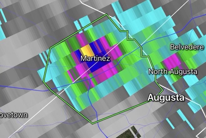
A volatile, high-energy summer weather pattern is producing aggressive downpours across the Central Savannah River Area. The National Weather Service (NWS) has issued urgent Flash Flood Warnings for portions of Columbia County and Richmond County in east-central Georgia, as slow-moving thunderstorm clusters unleash staggering rainfall rates of 1.25 to 2 inches per hour.
Whether you live in Augusta, Evans, Martinez, Grovetown, or surrounding rural and suburban communities, the rapid accumulation of water is creating dangerous, life-threatening conditions on roadways and low-lying areas. Understanding the severity of these rapid-onset floods and knowing how to respond is critical to protecting your family, property, and community.
Fast Facts: Columbia and Richmond Counties Flash Flood Event
Impacted Regions: Columbia County and Richmond County, Georgia (including the greater Augusta metropolitan area, Evans, Martinez, and Grovetown).
Rainfall Rates: Doppler radar and local rain gauges indicate intense downpours dropping 1.25 to 2 inches of rain per hour, quickly overwhelming urban drainage systems and small creeks.
Core Hazards: Rapidly rising street flooding, submerged underpasses, swollen creeks, hazardous hydroplaning conditions, and severe erosion in poor-drainage zones.
Issuing Agency: National Weather Service (NWS).
Action Required: Avoid all travel if possible, never drive across flooded roadways, and move immediately to higher ground if floodwaters threaten your property.
Why 1.25–2 Inches Per Hour Rates Trigger Immediate Flash Floods
When thunderstorms stall or train over the same area, ground absorption limits are quickly breached. Soils across the Central Savannah River Area can only process so much moisture at once.
When rainfall rates surge to 1.25 to 2 inches per hour, urban environments with extensive concrete, asphalt, and artificial drainage systems cannot shed the water fast enough. Within minutes, parking lots turn into shallow lakes, storm drains back up, and small creeks and urban ditches overflow their banks, turning ordinary intersections into treacherous rushing channels.
Flash Flood Safety Checklist: Protecting Your Family and Property
When a Flash Flood Warning is active, every minute counts. Adhering to fundamental safety guidelines can prevent tragedy:
Turn Around, Don’t Drown: Never drive, ride, or walk through flooded roadways. Just 6 inches of fast-moving water can knock an adult off their feet, and 12 inches of rushing water can carry away a small car. Floodwaters frequently hide washed-out road surfaces, deep potholes, and open hazards underneath.
Move to Higher Ground Immediately: If floodwaters begin rising around your home or property, move to higher floors or evacuate to elevated ground if instructed by local emergency management.
Stay Away from Storm Drains and Creeks: Fast-flowing water in drainage ditches, creeks, and canals acts like an undertow. Never allow children or pets to play near swollen waterways or flooded retention ponds.
Prepare for Utility Disruptions: Keep emergency kits, flashlights, extra batteries, and fully charged communication devices ready in case localized power outages occur due to severe storm activity.
Monitor Official Emergency Channels: Keep a NOAA Weather Radio tuned to your local frequency or enable emergency alerts on your smartphone for continuous updates, radar tracking, and all-clear notices from your regional NWS office.
Stay Informed
Weather conditions during peak summer convective seasons can shift from calm skies to severe deluges in a matter of minutes. Always keep a close eye on local radar, heed evacuation warnings from county officials, and respect the power of rising water.
Stay safe, stay alert, and protect your community!
Affiliate Disclosure: As an Amazon Associate, Radar Watch HQ earns from qualifying purchases.
Radar Watch HQ Top 5 Essential Emergency Preparedness Picks
Whether you’re preparing for severe thunderstorms, flash flooding, hurricanes, wildfires, or extended power outages, these five emergency essentials can help keep your household safer when severe weather strikes.
A portable power station provides reliable backup electricity during outages, allowing you to power phones, medical devices, laptops, lights, small appliances, and communication equipment without fuel.
Best for:
- Extended power outages
- Severe thunderstorms
- Hurricanes
- Winter storms
- Wildfires
2. Flood Protection Barriers & Sandless Flood Bags
Flood barriers help divert or absorb water before it enters garages, doorways, and low-lying areas. They deploy quickly and can help reduce property damage during flash flooding.
Best for:
- Flash Flood Warnings
- Heavy rainfall
- River flooding
- Coastal flooding
3. Rechargeable LED Flashlights
Bright, dependable flashlights are essential when the power goes out. Rechargeable or solar-powered models provide long-lasting illumination for navigating safely indoors and outdoors.
Best for:
- Overnight power outages
- Emergency evacuations
- Storm damage inspections
Keep phones, tablets, weather radios, and USB-powered devices charged when the electrical grid is unavailable. A solar power bank offers an additional charging option during prolonged emergencies.
Best for:
- Communication during outages
- Emergency weather alerts
- Travel and evacuation
A NOAA Weather Radio delivers official weather alerts directly from the National Weather Service, even when cellular networks or internet service are unavailable. It remains one of the most dependable ways to receive life-saving warnings.
Best for:
- Tornado warnings
- Severe thunderstorm warnings
- Flash flood warnings
- Hurricane alerts
- Winter storm emergencies
Why Radar Watch HQ Recommends These Essentials
At Radar Watch HQ, preparedness is just as important as staying informed. These five emergency essentials can help you stay connected, protect your property, and safely navigate severe weather events. Having supplies ready before storms arrive allows you to respond quickly when warnings are issued and conditions begin to deteriorate.