Rising Water Keeps Parts of Central Illinois Under Flood Warning
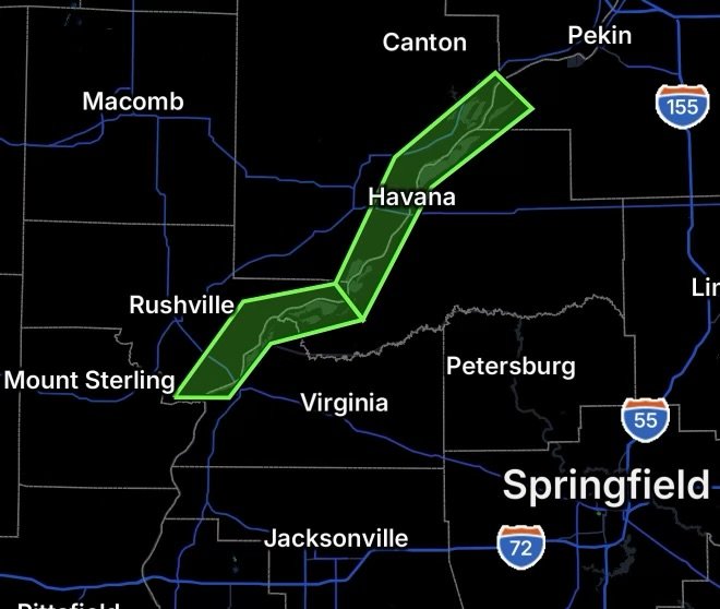
A Flood Warning remains in effect along the Illinois River near Havana and at Beardstown, Illinois, as elevated river levels continue to produce minor flooding across portions of the river basin. The National Weather Service in Lincoln extended the warnings Tuesday, August 25, citing observed river levels, soil moisture conditions and forecast precipitation. (National Weather Service)
Illinois River Near Havana
The Illinois River near Havana remains above its 14-foot flood stage. As of 8:45 a.m. Tuesday, the river stood at 15.7 feet, with a maximum stage of 16.0 feet during the previous 24 hours.
The National Weather Service reports that minor flooding is occurring and is forecast to continue. At this level, agricultural areas not protected by levees can experience flooding.
The river is forecast to gradually decline and fall below flood stage Friday afternoon, with additional decreases expected afterward. The Flood Warning is currently scheduled to continue through Friday evening. (National Weather Service)
The Havana-area warning affects portions of Cass County, Fulton County and Mason County. (National Weather Service)
Illinois River at Beardstown
Farther downstream, the Illinois River at Beardstown is also experiencing minor flooding.
The river’s flood stage is 14.0 feet, while the latest information from the National Weather Service placed the river around 16 feet, keeping water levels above flood stage. Forecast guidance indicates a gradual decline over the coming days. (Iowa Environmental Mesonet)
The Beardstown warning covers portions of Cass County, Morgan County, Brown County and Schuyler County. (National Weather Service)
Why River Flooding Can Continue After Heavy Rain
River flooding does not always end when rainfall stops. Water from upstream portions of the watershed can continue moving downstream, while already-saturated soils and additional precipitation can prolong elevated river levels.
Because the Illinois River is a large waterway, changes in river stage can occur gradually. As a result, communities downstream can remain at risk even after local weather conditions improve.
What Residents Should Watch For
Residents and businesses near the Illinois River should continue monitoring official river forecasts and local flood information.
Floodwater can cover roads, agricultural areas and other normally accessible locations. Water levels can also change unexpectedly, particularly following additional rainfall upstream.
Flood Safety Reminders
- Never drive through a flooded roadway.
- Turn around and use an alternate route when water covers the road.
- Do not walk through moving floodwater.
- Keep children and pets away from swollen rivers and flooded areas.
- Follow barricades and road closures.
- Residents in low-lying areas should be prepared for additional rises.
- Continue monitoring updated National Weather Service forecasts.
The National Weather Service specifically urges people with interests along the affected rivers to remain aware of the latest forecasts and associated flood risk. (National Weather Service)
Radar Watch HQ Final Thoughts
The Illinois River flood situation near Havana and Beardstown remains a concern across parts of central Illinois, although current forecasts indicate that river levels should gradually decline.
For residents near the river and surrounding low-lying areas, the best approach is to stay informed, avoid flooded roads and remain prepared for changing conditions. Even when water begins falling, lingering flooding can continue until river levels return below flood stage.
Radar Watch HQ will continue to monitor the Illinois River and provide updates as conditions change.
Stay weather-aware. Stay prepared. Stay safe.

Affiliate Disclosure: As an Amazon Associate, Radar Watch HQ earns from qualifying purchases.
Radar Watch HQ Top 5 Essential Emergency Preparedness Picks
Whether you’re preparing for severe thunderstorms, flash flooding, hurricanes, wildfires, or extended power outages, these five emergency essentials can help keep your household safer when severe weather strikes.
A portable power station provides reliable backup electricity during outages, allowing you to power phones, medical devices, laptops, lights, small appliances, and communication equipment without fuel.
Best for:
- Extended power outages
- Severe thunderstorms
- Hurricanes
- Winter storms
- Wildfires
2. Flood Protection Barriers & Sandless Flood Bags
Flood barriers help divert or absorb water before it enters garages, doorways, and low-lying areas. They deploy quickly and can help reduce property damage during flash flooding.
Best for:
- Flash Flood Warnings
- Heavy rainfall
- River flooding
- Coastal flooding
3. Rechargeable LED Flashlights
Bright, dependable flashlights are essential when the power goes out. Rechargeable or solar-powered models provide long-lasting illumination for navigating safely indoors and outdoors.
Best for:
- Overnight power outages
- Emergency evacuations
- Storm damage inspections
Keep phones, tablets, weather radios, and USB-powered devices charged when the electrical grid is unavailable. A solar power bank offers an additional charging option during prolonged emergencies.
Best for:
- Communication during outages
- Emergency weather alerts
- Travel and evacuation
A NOAA Weather Radio delivers official weather alerts directly from the National Weather Service, even when cellular networks or internet service are unavailable. It remains one of the most dependable ways to receive life-saving warnings.
Best for:
- Tornado warnings
- Severe thunderstorm warnings
- Flash flood warnings
- Hurricane alerts
- Winter storm emergencies
Why Radar Watch HQ Recommends These Essentials
At Radar Watch HQ, preparedness is just as important as staying informed. These five emergency essentials can help you stay connected, protect your property, and safely navigate severe weather events. Having supplies ready before storms arrive allows you to respond quickly when warnings are issued and conditions begin to deteriorate.