River Flooding Continues Across Indiana and Illinois
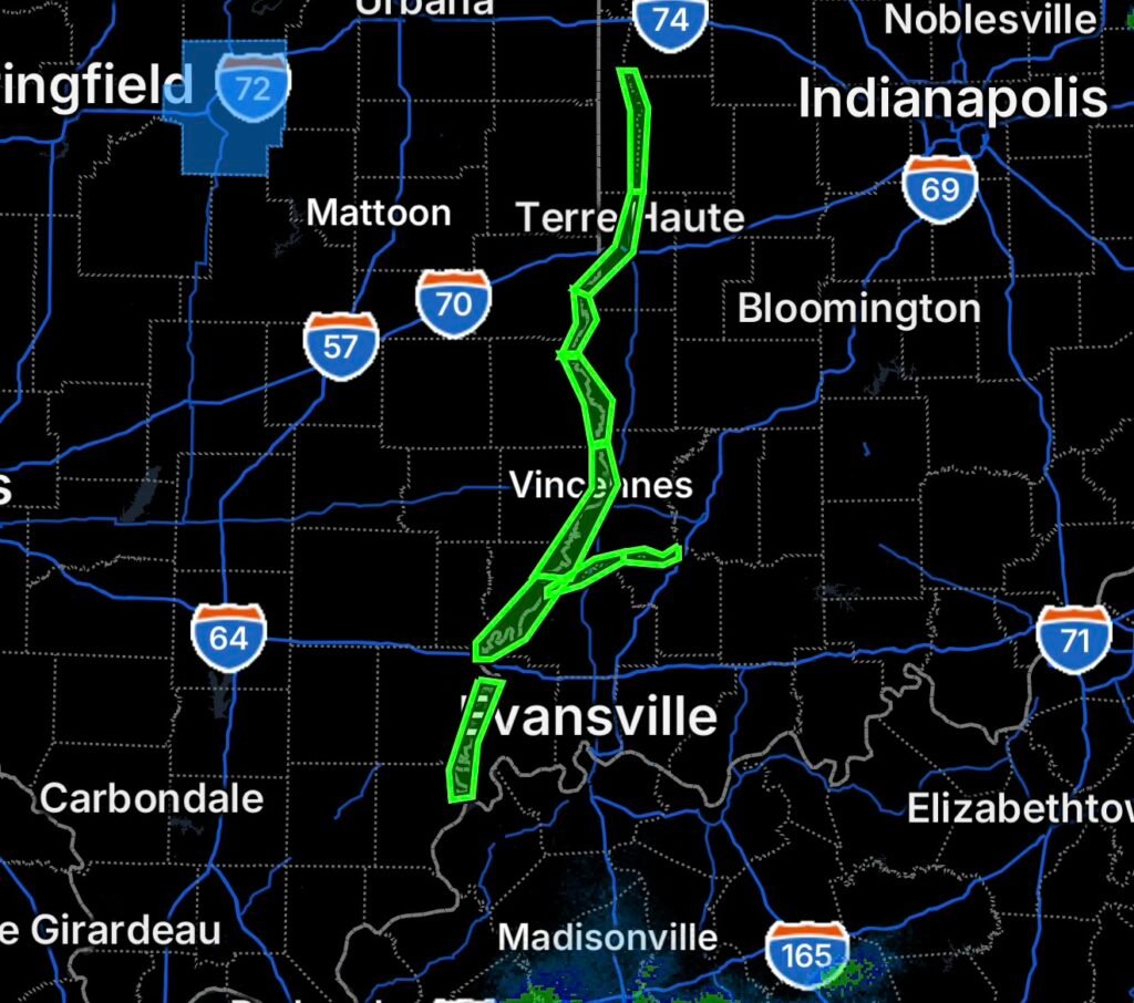
A Flood Warning remains in effect across portions of the Wabash and White river systems on August 26, 2026, as elevated river levels continue to produce minor flooding across multiple communities in Indiana and Illinois.
The latest National Weather Service information indicates that minor flooding continues along the Wabash River from Montezuma downstream through Mount Carmel, while flooding along the White River continues downstream from Edwardsport toward Hazleton. The Wabash crest has been moving downstream toward the lower portions of the river system. (National Weather Service)
Wabash River Flooding
The Flood Warning covers several river forecast points, including:
- Montezuma
- Terre Haute
- Hutsonville Legacy Power Plant Site
- Riverton
- Vincennes
- Mount Carmel
- New Harmony
These locations are connected by the long downstream path of the Wabash River. As a result, flooding does not occur everywhere at the same time. Instead, the river crest gradually moves downstream, keeping different communities at risk as water levels rise and fall.
Recent National Weather Service information reported minor flooding continuing from Montezuma through Mount Carmel, with the crest approaching Vincennes. (National Weather Service)
Montezuma and Terre Haute
The upper portion of the warned area has experienced some of the more significant river impacts during this flooding episode.
At Montezuma, earlier river observations showed the river reaching levels capable of overtopping the local agricultural levee and flooding low bottomlands. (National Weather Service)
Terre Haute has also experienced prolonged elevated river levels as the main crest moved through the area.
Riverton and Hutsonville
Downstream communities, including Riverton and Hutsonville, have remained vulnerable as the flood crest progresses southward.
Earlier National Weather Service statements indicated that the crest was near Riverton while minor flooding continued along the Wabash. (National Weather Service)
Residents near the river should continue monitoring updated river forecasts because water levels can remain elevated even after the primary crest passes.
Vincennes and Mount Carmel
The flood wave continues moving toward Vincennes and Mount Carmel, extending the period of river flooding farther downstream.
Although the current flooding is characterized as minor along much of the warned stretch, minor flooding can still affect low-lying roads, agricultural land, river access points, parks and other areas close to the river.
White River Flooding
The White River is also experiencing minor flooding.
The latest National Weather Service statement reported minor flooding from Edwardsport downstream toward Hazleton, with the crest already having passed Hazleton. (National Weather Service)
Hazleton and Petersburg
Communities near Hazleton and Petersburg should continue watching river levels and local conditions, particularly in low-lying areas adjacent to the White River.
Even when the river crest has passed, flooding can take time to subside because water remains in floodplains, drainage systems and low-lying terrain.
Wabash River at New Harmony
Farther downstream, New Harmony remains an important location to monitor as water continues moving south along the Wabash River.
Because river flooding progresses downstream over time, communities farther south can experience elevated water levels after areas upstream have already begun improving.
Why River Flooding Can Last for Days
River flooding behaves differently from flash flooding.
Heavy rainfall upstream can send large volumes of water into a river system. That water then travels downstream, producing a flood crest that can take days to move through multiple river forecast points.
Consequently, dry weather at a particular location does not necessarily mean the river will immediately fall below flood stage.
In this case, National Weather Service forecasters noted that additional scattered storms were not expected to significantly affect main-stem river levels, meaning the existing flooding was primarily being driven by the ongoing river response rather than a new major rainfall event. (National Weather Service)
Flood Safety Remains Important
Flooded areas can remain dangerous even when water appears shallow.
If you encounter a flooded roadway:
Turn around, don’t drown.
Never drive around barricades or attempt to cross a flooded road. Water can conceal washed-out pavement, debris and rapidly changing currents. The National Weather Service specifically warns that most flood deaths occur in vehicles. (National Weather Service)
Residents near the Wabash and White rivers should also:
- Monitor updated river forecasts and Flood Warning information.
- Avoid flooded parks, riverbanks and low-water crossings.
- Keep children and pets away from rapidly moving water.
- Follow road closures and local emergency instructions.
- Avoid unnecessary nighttime travel through flood-prone areas.
- Move vehicles and important belongings away from rising water when advised.
Radar Watch HQ Final Thoughts
The August 26, 2026 Flood Warning along the Wabash and White rivers highlights how river flooding can continue long after the heaviest rainfall has ended. From Montezuma and Terre Haute to Riverton, Vincennes, Mount Carmel and New Harmony, the Wabash flood crest continues its downstream progression, while the White River remains elevated around the Petersburg and Hazleton areas.
Conditions can change as river levels rise and fall, so residents should continue monitoring official updates until the warnings are discontinued.
Stay weather-aware, avoid flooded roads, and remember: Turn around, don’t drown.

Affiliate Disclosure: As an Amazon Associate, Radar Watch HQ earns from qualifying purchases.
Radar Watch HQ Top 5 Essential Emergency Preparedness Picks
Whether you’re preparing for severe thunderstorms, flash flooding, hurricanes, wildfires, or extended power outages, these five emergency essentials can help keep your household safer when severe weather strikes.
A portable power station provides reliable backup electricity during outages, allowing you to power phones, medical devices, laptops, lights, small appliances, and communication equipment without fuel.
Best for:
- Extended power outages
- Severe thunderstorms
- Hurricanes
- Winter storms
- Wildfires
2. Flood Protection Barriers & Sandless Flood Bags
Flood barriers help divert or absorb water before it enters garages, doorways, and low-lying areas. They deploy quickly and can help reduce property damage during flash flooding.
Best for:
- Flash Flood Warnings
- Heavy rainfall
- River flooding
- Coastal flooding
3. Rechargeable LED Flashlights
Bright, dependable flashlights are essential when the power goes out. Rechargeable or solar-powered models provide long-lasting illumination for navigating safely indoors and outdoors.
Best for:
- Overnight power outages
- Emergency evacuations
- Storm damage inspections
Keep phones, tablets, weather radios, and USB-powered devices charged when the electrical grid is unavailable. A solar power bank offers an additional charging option during prolonged emergencies.
Best for:
- Communication during outages
- Emergency weather alerts
- Travel and evacuation
A NOAA Weather Radio delivers official weather alerts directly from the National Weather Service, even when cellular networks or internet service are unavailable. It remains one of the most dependable ways to receive life-saving warnings.
Best for:
- Tornado warnings
- Severe thunderstorm warnings
- Flash flood warnings
- Hurricane alerts
- Winter storm emergencies
Why Radar Watch HQ Recommends These Essentials
At Radar Watch HQ, preparedness is just as important as staying informed. These five emergency essentials can help you stay connected, protect your property, and safely navigate severe weather events. Having supplies ready before storms arrive allows you to respond quickly when warnings are issued and conditions begin to deteriorate.