Stronger Winds Develop Tonight Across the Chesapeake Bay
A Marine Weather Statement is drawing attention to changing conditions across portions of the Chesapeake Bay and the Tidal Potomac River on Wednesday, August 26, 2026. Boaters should closely monitor conditions as winds strengthen this evening, creating increasingly difficult conditions for smaller vessels.
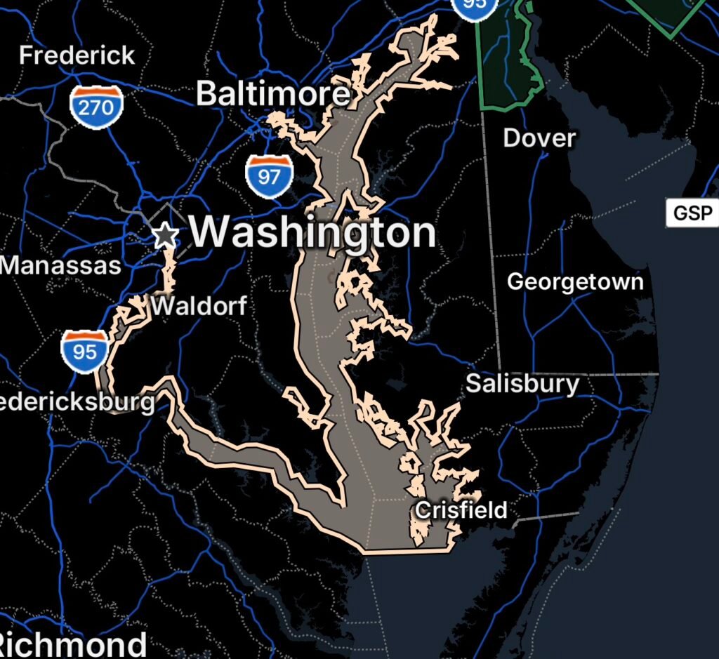
The affected waters include the Chesapeake Bay and adjoining estuaries north of Smith Point, Virginia, as well as the Tidal Potomac from Key Bridge to Smith Point, Virginia.
What Boaters Need to Know
The National Weather Service is forecasting a notable increase in southerly winds tonight. Across several Chesapeake Bay zones, winds are expected to reach 15 to 20 knots, with gusts up to 25 knots, while waves may build to around 3 feet in some areas. (National Weather Service)
These conditions can become hazardous quickly, particularly for smaller recreational boats, kayaks, paddlecraft, and vessels with limited stability.
Chesapeake Bay Conditions
The most significant deterioration is expected during the evening and overnight hours. The Chesapeake Bay from Pooles Island, Maryland, southward toward Smith Point, Virginia, is included in the broader marine hazard area.
Forecasts indicate that southerly winds will increase during the evening, with waves building as the wind strengthens. (National Weather Service)
Additionally, a cold front approaching from the northwest Thursday could bring showers and thunderstorms. Gusty winds and locally higher waves are possible near thunderstorms. (National Weather Service)
Tidal Potomac River
The Tidal Potomac from Key Bridge to Smith Point, Virginia, is also an important area for boaters to monitor.
As southerly winds increase, portions of the river may become rougher, especially in exposed stretches and areas where wind can funnel along the waterway.
Boaters should avoid assuming that calmer conditions earlier in the day will continue through the evening.
Why Conditions Can Become Hazardous
Wind-driven waves can increase rapidly when stronger winds persist over open water. Even relatively modest waves can become difficult for smaller boats when combined with gusty winds and changing currents.
Furthermore, thunderstorms can produce sudden wind shifts and stronger gusts than the surrounding forecast conditions. The National Weather Service notes that winds and waves can be higher, while visibility can decrease, in and near thunderstorms. (National Weather Service)
Areas to Monitor
The marine weather concern covers waters including:
- Chesapeake Bay and adjoining estuaries north of Smith Point, Virginia
- Chesapeake Bay from Pooles Island to Sandy Point
- Chesapeake Bay from Sandy Point to North Beach
- Chesapeake Bay from North Beach to Drum Point
- Chesapeake Bay from Drum Point to Smith Point
- Tidal Potomac waterways extending toward Smith Point
- Connected rivers, creeks, and estuaries affected by the strengthening winds
Boating Safety Tips
Check Conditions Before Leaving
Before heading onto the water, check the latest marine forecast, wind speeds, wave heights, and active advisories.
Smaller Boats Face Greater Risk
Small craft can be especially vulnerable to steepening waves and gusty winds. Inexperienced mariners should strongly consider remaining in port when hazardous conditions develop.
Wear a Life Jacket
Everyone aboard should wear a properly fitted U.S. Coast Guard-approved life jacket. Conditions can deteriorate quickly, making an unexpected fall overboard much more dangerous.
Watch Thunderstorms Closely
Thunderstorms can produce sudden gusts, lightning, heavy rain, reduced visibility, and rapidly changing wind direction. If storms approach, move toward a safe harbor whenever possible.
Conditions Could Remain Active Thursday
The marine forecast calls for continued southerly winds Thursday, with additional chances for showers and thunderstorms. A cold front is expected to approach from the northwest before eventually moving southeast and weakening. (National Weather Service)
Therefore, mariners should continue monitoring updated forecasts rather than assuming conditions will immediately improve after tonight.
Radar Watch HQ Final Thoughts
The Chesapeake Bay and Tidal Potomac can change from relatively calm to hazardous in a short period when stronger winds and thunderstorms develop. For August 26, boaters should pay particular attention to the evening and overnight period as southerly winds increase.
If your vessel is small or you are inexperienced on the water, consider staying ashore until conditions improve. Those already on the water should monitor weather updates, maintain a safe distance from thunderstorms, and be prepared to return to port.
Stay weather-aware, stay prepared, and keep checking Radar Watch HQ for the latest weather developments.

Radar Watch HQ Top 5 Marine Essentials
Affiliate Disclosure: As an Amazon Associate, Radar Watch HQ earns from qualifying purchases.
🌊 1. U.S. Coast Guard-Approved Life Jacket
A properly fitted life jacket is the most important piece of safety equipment for every passenger onboard.
Best for: Recreational boaters, anglers, kayakers, and paddleboarders.
⚓ 2. Marine Emergency Radio (NOAA Weather Radio)
Receive real-time NOAA Weather Radio alerts, marine forecasts, and emergency warnings—even when cell service is unavailable.
Best for: Offshore and coastal boating.
🔦 3. Rechargeable Waterproof LED Flashlight
A bright waterproof flashlight is essential for emergencies, low visibility, nighttime navigation, and signaling for help.
Best for: Every boat emergency kit.
🧰 4. Marine First Aid Kit
A waterproof first aid kit stocked with bandages, antiseptic, medications, and emergency supplies for injuries on the water.
Best for: Every vessel, regardless of size.
🧭 5. Waterproof Dry Bag
Protect phones, wallets, charts, keys, electronics, and emergency supplies from water damage during storms or rough seas.
Best for: Boaters, kayakers, paddleboarders, and beachgoers.
🛒 Radar Watch HQ Marine Safety Picks
Prepare before you head out on the water. Our recommended marine safety essentials can help keep you and your crew safe during changing weather conditions.