Flood Watch Expands Across the New York City, New Jersey, Pennsylvania and Delaware Region
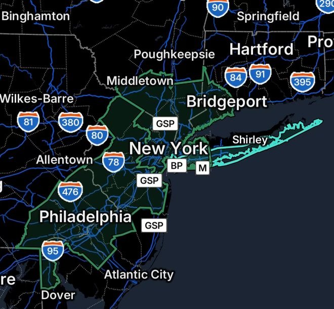
A broad Flood Watch is in effect across portions of the Northeast on Wednesday, August 26, 2026, covering communities from northern Delaware and southeastern Pennsylvania through New Jersey, Connecticut, New York City and surrounding areas. Meanwhile, a Rip Current Statement highlights dangerous swimming conditions along portions of the New York coastline.
The combination of potentially heavy rainfall and saturated or vulnerable areas could lead to urban flooding, poor drainage flooding, rises along small streams and difficult travel conditions.
Flood Watch Areas in Northern Delaware and New Jersey
The Flood Watch includes portions of northern Delaware, including New Castle County.
In New Jersey, areas included are:
- Camden County
- Gloucester County
- Hunterdon County
- Mercer County
- Middlesex County
- Morris County
- Northwestern Burlington County
- Somerset County
- Sussex County
- Western Monmouth County
Residents should monitor rainfall trends, especially if thunderstorms repeatedly move across the same locations. Low-lying roads, underpasses and areas with poor drainage can flood quickly when rainfall rates increase.
Southeast Pennsylvania Flood Risk
The Flood Watch also covers portions of southeastern Pennsylvania, including:
- Delaware County
- Eastern Chester County
- Eastern Montgomery County
- Lower Bucks County
- Philadelphia County
- Upper Bucks County
- Western Chester County
- Western Montgomery County
The Philadelphia metropolitan area can be particularly vulnerable to flash flooding and urban drainage problems during periods of intense rainfall. Motorists should never drive through flooded roadways because water depth and road conditions can be difficult to judge.
Connecticut Flood Watch
Portions of southern Connecticut are also included in the Flood Watch, specifically:
- Northern Fairfield County
- Southern Fairfield County
Heavy rainfall could produce localized flooding, particularly near small streams, drainage areas and locations that receive repeated downpours.
Why Heavy Rain Can Cause Flooding
When rainfall falls faster than soil, drainage systems and waterways can absorb or carry it away, water begins accumulating on the surface. In developed areas, pavement and buildings can accelerate runoff.
Furthermore, repeated thunderstorms over the same area can quickly overwhelm drainage systems and cause water levels to rise.
Northeast New Jersey and New York Flood Threat
The Flood Watch extends into northeast New Jersey, including:
- Eastern Bergen County
- Eastern Essex County
- Eastern Passaic County
- Eastern Union County
- Hudson County
- Western Bergen County
- Western Essex County
- Western Passaic County
- Western Union County
The threat also reaches southeastern New York, including New York City and surrounding counties.
Affected areas include:
- Bronx County
- Kings County (Brooklyn)
- New York County (Manhattan)
- Northern Nassau County
- Northern Queens County
- Northern Westchester County
- Orange County
- Putnam County
- Richmond County (Staten Island)
- Rockland County
- Southern Nassau County
- Southern Queens County
- Southern Westchester County
Because of the large population and extensive urban development across the New York City metropolitan area, intense rainfall can create rapid street and roadway flooding even when nearby rivers remain within their banks.
Rip Current Statement for Long Island and New York City Beaches
A Rip Current Statement is also in effect for:
- Kings County (Brooklyn)
- Southwest Suffolk County
- Southeast Suffolk County
- Southern Queens County
- Southern Nassau County
Beachgoers should use extra caution in the surf. Rip currents are powerful channels of water moving away from the shoreline and can pull swimmers away from the beach.
What to Do If Caught in a Rip Current
If you are caught in a rip current:
- Stay calm and do not fight the current directly.
- Float or tread water while you regain control.
- Swim parallel to the shoreline until you are out of the current.
- Then swim toward shore.
- If you cannot escape, wave for assistance and call for help.
Whenever possible, swim near lifeguards and follow posted beach warnings.
Flood Safety: What Residents Should Know
With a Flood Watch in effect, residents should remain weather-aware and be prepared for changing conditions.
During Heavy Rain
- Avoid unnecessary travel during the heaviest rainfall.
- Never drive through flooded roads.
- Stay away from swollen streams and drainage channels.
- Move to higher ground if flooding begins around your location.
- Keep phones charged in case of power outages or emergency notifications.
- Monitor official weather and emergency-management updates.
Remember: Turn Around, Don’t Drown
Floodwater can be much deeper and stronger than it appears. Even shallow moving water can sweep a vehicle or person off course.
If a roadway is covered by water, turn around and find another route.
Radar Watch HQ Final Thoughts
The widespread Flood Watch across parts of Delaware, Pennsylvania, New Jersey, Connecticut and New York underscores the potential for dangerous flooding when heavy rainfall develops across a densely populated region. At the same time, the Rip Current Statement serves as an important reminder that hazardous conditions can extend beyond inland flooding to the coastline.
Conditions can change quickly. Stay alert, monitor updated forecasts and warnings, and take action early if flooding develops.
Stay weather-aware, stay prepared, and stay safe with Radar Watch HQ.

Affiliate Disclosure: As an Amazon Associate, Radar Watch HQ earns from qualifying purchases.
Radar Watch HQ Top 5 Essential Emergency Preparedness Picks
Whether you’re preparing for severe thunderstorms, flash flooding, hurricanes, wildfires, or extended power outages, these five emergency essentials can help keep your household safer when severe weather strikes.
A portable power station provides reliable backup electricity during outages, allowing you to power phones, medical devices, laptops, lights, small appliances, and communication equipment without fuel.
Best for:
- Extended power outages
- Severe thunderstorms
- Hurricanes
- Winter storms
- Wildfires
2. Flood Protection Barriers & Sandless Flood Bags
Flood barriers help divert or absorb water before it enters garages, doorways, and low-lying areas. They deploy quickly and can help reduce property damage during flash flooding.
Best for:
- Flash Flood Warnings
- Heavy rainfall
- River flooding
- Coastal flooding
3. Rechargeable LED Flashlights
Bright, dependable flashlights are essential when the power goes out. Rechargeable or solar-powered models provide long-lasting illumination for navigating safely indoors and outdoors.
Best for:
- Overnight power outages
- Emergency evacuations
- Storm damage inspections
Keep phones, tablets, weather radios, and USB-powered devices charged when the electrical grid is unavailable. A solar power bank offers an additional charging option during prolonged emergencies.
Best for:
- Communication during outages
- Emergency weather alerts
- Travel and evacuation
A NOAA Weather Radio delivers official weather alerts directly from the National Weather Service, even when cellular networks or internet service are unavailable. It remains one of the most dependable ways to receive life-saving warnings.
Best for:
- Tornado warnings
- Severe thunderstorm warnings
- Flash flood warnings
- Hurricane alerts
- Winter storm emergencies
Why Radar Watch HQ Recommends These Essentials
At Radar Watch HQ, preparedness is just as important as staying informed. These five emergency essentials can help you stay connected, protect your property, and safely navigate severe weather events. Having supplies ready before storms arrive allows you to respond quickly when warnings are issued and conditions begin to deteriorate.