Severe Thunderstorm Watch, Flood Watch and Warning Signal Dangerous Weather
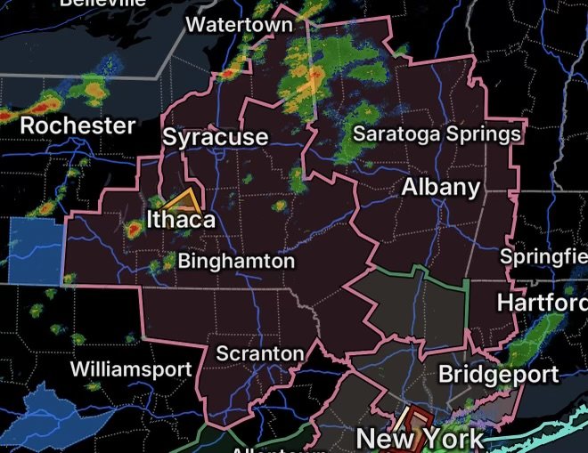
The Northeast is facing a combination of severe thunderstorms and flooding threats today, August 27, 2026. A Severe Thunderstorm Watch covers portions of Connecticut, Massachusetts, New York, Pennsylvania and Vermont, while a Flood Watch is in effect for Dutchess and Ulster counties in eastern New York. Meanwhile, a Severe Thunderstorm Warning has been issued for communities in and around Tompkins, Cayuga and southern Cortland counties.
Residents should remain weather-aware as thunderstorms can produce damaging winds, frequent lightning, torrential rainfall and localized flash flooding.
Severe Thunderstorm Watch Covers Multiple States
The Severe Thunderstorm Watch includes portions of:
- Far western Connecticut
- Far western Massachusetts
- New York
- Northeastern Pennsylvania
- Far southern Vermont
A watch means conditions are favorable for severe thunderstorms. Storms that develop may produce damaging wind gusts, large hail, frequent lightning and intense rainfall.
Why These Storms Can Become Severe
Strong thunderstorms can develop when warm, humid air combines with atmospheric instability and sufficient wind shear. As storms strengthen, powerful downdrafts can generate damaging straight-line winds.
Additionally, storms moving repeatedly over the same areas can produce rapid rainfall accumulation and flooding, especially where soils are already saturated.
Flood Watch for Eastern New York
A Flood Watch is in effect for:
- Dutchess County, New York
- Ulster County, New York
Periods of heavy thunderstorms can produce rainfall faster than the ground and drainage systems can absorb it. This can result in flash flooding of roads, poor-drainage areas, small streams and low-lying locations.
Flooding Can Develop Quickly
Even if rainfall totals vary from one location to another, thunderstorms can drop significant amounts of rain in a short period. Residents should never drive through flooded roadways because water depth and current strength can be difficult to judge.
Turn around, don’t drown.
Severe Thunderstorm Warning for Central New York
A Severe Thunderstorm Warning has been issued for:
- Lansing
- Groton
- Locke
- Dryden
- Moravia
- Freeville
- Montville
- West Groton
- Lansingville
- Peruville
A warning means a severe thunderstorm is occurring or has been detected nearby and residents in the warned area should take immediate precautions.
What Residents Should Do
If you are in or near the warned area:
- Move indoors immediately.
- Stay away from windows and exterior doors.
- Avoid unnecessary travel during the strongest part of the storm.
- Unplug sensitive electronics if lightning becomes frequent and it is safe to do so.
- Never shelter under trees during thunderstorms.
- Be prepared for sudden flooding on roads and in low-lying areas.
Lightning and Damaging Winds Remain Major Concerns
Thunderstorms do not need to produce a tornado to become dangerous. Damaging winds and lightning can cause injuries, property damage and power outages.
Lightning can strike several miles away from the main storm, so outdoor activities should be postponed until the storm has completely passed.
Strong wind gusts can also bring down tree limbs and power lines. Treat every downed power line as energized and stay well away from it.
Northeast Weather Threat: What to Watch Today
The combination of a severe thunderstorm watch, active warning and flood watch means conditions can change rapidly across the region.
Residents should monitor updated warnings throughout the day, particularly if storms begin developing nearby. A watch means be prepared; a warning means take action.
Radar Watch HQ Final Thoughts
The Northeast is dealing with a multi-hazard weather situation involving severe thunderstorms, heavy rainfall and potential flooding. The most immediate concern is the Severe Thunderstorm Warning affecting communities in central New York, while residents across the broader watch area should remain prepared for additional storm development.
Keep phones charged, monitor weather alerts and avoid unnecessary travel during the strongest storms. If flooding begins, move to higher ground and never attempt to cross a flooded roadway.
Stay alert, stay prepared and stay weather-aware with Radar Watch HQ.