Multiple Weather Alerts Put Delaware, New Jersey, Pennsylvania and New York on Alert
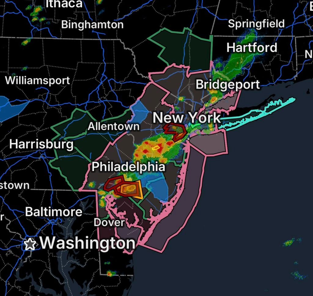
A dangerous combination of flooding, severe thunderstorms, dangerous surf and power outages is affecting parts of the Northeast on Thursday, August 27, 2026. A broad Flood Watch covers portions of Delaware, New Jersey and Pennsylvania, while Severe Thunderstorm Watches and Flash Flood Warnings highlight the potential for rapidly changing conditions.
Residents should remain weather-aware as thunderstorms move through the region, particularly where heavy rainfall could overwhelm drainage systems and produce flash flooding.
Flood Watch Covers Three States
The Flood Watch includes portions of:
Delaware
- New Castle County
New Jersey
- Camden County
- Gloucester County
- Hunterdon County
- Mercer County
- Middlesex County
- Morris County
- Northwestern Burlington County
- Somerset County
- Sussex County
- Warren County
- Western Monmouth County
Pennsylvania
- Berks County
- Delaware County
- Eastern Chester County
- Eastern Montgomery County
- Lehigh County
- Lower Bucks County
- Northampton County
- Philadelphia County
- Upper Bucks County
- Western Chester County
- Western Montgomery County
Periods of heavy rain can cause rapid rises in creeks and streams, flooding in low-lying areas and dangerous travel conditions. Urban locations may also experience significant street flooding when rainfall rates exceed drainage capacity.
Flash Flood Warning in Northern New Jersey
A Flash Flood Warning is in effect for Middlesex County and southeastern Somerset County in northern New Jersey.
Flash flooding can develop quickly, sometimes within minutes of intense rainfall. Water covering roads may be deeper and faster-moving than it appears.
Never drive through flooded roadways. Turn around and find an alternate route if water is covering the pavement.
Severe Thunderstorm Watch Expands the Threat
A Severe Thunderstorm Watch covers portions of:
- Southwest Connecticut
- Northern Delaware
- New Jersey
- Southeast New York
- Far Southeast Pennsylvania
- Coastal waters
The watch means conditions are favorable for severe thunderstorms. Individual storms could bring damaging wind gusts, frequent lightning, torrential rainfall and potentially large hail.
Thunderstorms can also produce dangerous wind shifts and rapidly deteriorating visibility, especially for motorists and boaters.
Why These Storms Can Produce Flooding
When thunderstorms repeatedly move across the same locations, rainfall can accumulate faster than soil, streams and drainage systems can absorb it. This process can create localized flash flooding even when rainfall totals vary considerably from one neighborhood to another.
Burlington County Power Outage Adds Another Concern
A power outage has been reported in Burlington County, New Jersey, adding another potential hazard as thunderstorms affect the area.
Residents experiencing outages should avoid downed power lines and keep clear of any electrical equipment that may have been damaged by water or storms. Have flashlights, charged mobile devices and backup power available if conditions deteriorate.
Dangerous Rip Currents Along Long Island
A Rip Current Statement is in effect for:
- Kings County (Brooklyn)
- Southwest Suffolk County
- Southeast Suffolk County
- Southern Queens County
- Southern Nassau County
Rip currents are powerful channels of water flowing away from the shoreline. Even experienced swimmers can be caught in them.
If caught in a rip current, do not fight directly against the current. Stay calm and swim parallel to the shoreline until you are out of the current, then head back toward shore.
Coastal Waters Face Thunderstorm Hazards
The Severe Thunderstorm Watch also includes coastal waters. Thunderstorms can create sudden wind gusts, lightning, heavy rain and rapidly changing marine conditions.
Boaters should monitor updated marine weather information and consider remaining in port when thunderstorms approach.
What Residents Should Do Now
With multiple hazards occurring across the region, residents should:
- Monitor weather alerts throughout the day.
- Move indoors immediately when thunderstorms approach.
- Avoid flooded roads and low-water crossings.
- Never drive around barricades.
- Stay away from downed power lines.
- Keep phones and backup batteries charged.
- Secure loose outdoor objects before strong winds arrive.
- Have flashlights available during possible power interruptions.
- Check on vulnerable family members and neighbors when safe.
- Avoid swimming when rip currents are present.
- Monitor coastal and marine conditions before boating.
Radar Watch HQ Final Thoughts
Thursday’s weather setup demonstrates how several hazards can occur at the same time. Flooding, severe thunderstorms, power outages, dangerous rip currents and coastal hazards are all part of today’s regional threat across portions of the Northeast.
The most important message is to remain alert and act quickly when warnings are issued. Conditions can change rapidly during summer thunderstorms, especially when heavy rainfall and strong winds occur together.
Stay weather-aware, avoid flooded roads, get indoors when storms approach, and always take Flash Flood and Severe Thunderstorm Warnings seriously.

Affiliate Disclosure: As an Amazon Associate, Radar Watch HQ earns from qualifying purchases.
Radar Watch HQ Top 5 Essential Emergency Preparedness Picks
Whether you’re preparing for severe thunderstorms, flash flooding, hurricanes, wildfires, or extended power outages, these five emergency essentials can help keep your household safer when severe weather strikes.
A portable power station provides reliable backup electricity during outages, allowing you to power phones, medical devices, laptops, lights, small appliances, and communication equipment without fuel.
Best for:
- Extended power outages
- Severe thunderstorms
- Hurricanes
- Winter storms
- Wildfires
2. Flood Protection Barriers & Sandless Flood Bags
Flood barriers help divert or absorb water before it enters garages, doorways, and low-lying areas. They deploy quickly and can help reduce property damage during flash flooding.
Best for:
- Flash Flood Warnings
- Heavy rainfall
- River flooding
- Coastal flooding
3. Rechargeable LED Flashlights
Bright, dependable flashlights are essential when the power goes out. Rechargeable or solar-powered models provide long-lasting illumination for navigating safely indoors and outdoors.
Best for:
- Overnight power outages
- Emergency evacuations
- Storm damage inspections
Keep phones, tablets, weather radios, and USB-powered devices charged when the electrical grid is unavailable. A solar power bank offers an additional charging option during prolonged emergencies.
Best for:
- Communication during outages
- Emergency weather alerts
- Travel and evacuation
A NOAA Weather Radio delivers official weather alerts directly from the National Weather Service, even when cellular networks or internet service are unavailable. It remains one of the most dependable ways to receive life-saving warnings.
Best for:
- Tornado warnings
- Severe thunderstorm warnings
- Flash flood warnings
- Hurricane alerts
- Winter storm emergencies
Why Radar Watch HQ Recommends These Essentials
At Radar Watch HQ, preparedness is just as important as staying informed. These five emergency essentials can help you stay connected, protect your property, and safely navigate severe weather events. Having supplies ready before storms arrive allows you to respond quickly when warnings are issued and conditions begin to deteriorate.