Post-Tropical Cyclone Iselle: California Coast Braces for Swells and Rip Currents
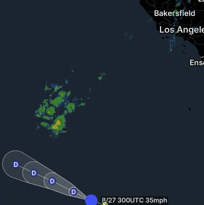
Post-Tropical Cyclone Iselle is no longer a tropical storm, but its influence is not completely gone. As the former Eastern Pacific system moves farther west over the Pacific, swells generated by Iselle are reaching portions of the California coastline, creating hazardous ocean conditions even though the cyclone itself remains far offshore.
The National Weather Service in Los Angeles/Oxnard specifically notes that south to southeast swells associated with Tropical Storm Iselle are bringing larger surf and strong rip currents to Los Angeles and Ventura counties, with surf around 3 to 6 feet in the affected areas.
For beachgoers, surfers, swimmers and boaters, the biggest concern is not direct tropical-storm winds. Instead, the threat comes from long-period swells, stronger breaking waves, rip currents and unpredictable nearshore conditions.
🌊 What Iselle’s Remnants Mean for California
Although Iselle is now classified as a post-tropical cyclone, the ocean does not immediately become calm when a tropical cyclone loses its official classification.
A storm can continue generating and organizing waves over a large area. Those waves then travel away from the storm and can reach distant coastlines days later.
Iselle has already produced significant southerly swell across the eastern Pacific. As that energy spreads toward California, beaches that normally experience less significant wave energy from southerly directions can see noticeably rougher surf.
Current observations and forecasts show that elevated surf and rip-current concerns are already affecting Southern California beaches.
🏖️ Southern California: Where Beach Hazards Could Increase
Los Angeles County
Los Angeles County beaches are among the areas being watched closely.
The National Weather Service has issued a Beach Hazards Statement covering Los Angeles County beaches, the Malibu Coast, Ventura County beaches, and the Catalina and Santa Barbara Islands because of elevated surf, breaking waves and dangerous rip currents.
The combination of larger waves and stronger currents can create dangerous conditions even for experienced swimmers.
Particularly vulnerable locations include:
- Malibu and exposed west- and south-facing beaches
- Los Angeles County beaches
- Areas near piers, jetties and rocky shoreline
- Beaches with strong wave breaks
- Popular surfing and swimming areas
Ventura County
Ventura County can also experience enhanced surf as southerly swell energy reaches the coast.
The greatest impacts will generally occur along beaches directly exposed to the incoming swell direction. Larger waves can break farther from shore, while powerful water movement can strengthen rip currents.
Beachgoers should check the latest local beach forecast before entering the water.
Santa Barbara and the Channel Islands
The Santa Barbara coastline and Channel Islands can also experience changing surf conditions as Pacific swell energy moves through the region.
The islands and exposed beaches can be especially sensitive to changes in swell direction. Consequently, conditions may vary significantly from one beach to another.
🌊 Why Rip Currents Are the Biggest Concern
One of the most dangerous aspects of an incoming swell is that the ocean can look manageable while currents underneath the surface become much stronger.
Rip currents are narrow, powerful channels of water moving away from the shoreline. When larger waves arrive, the amount of water moving toward the beach increases. That water must return offshore somewhere, which can intensify existing rip-current channels.
The National Weather Service warns that rip currents can pull swimmers and surfers away from shore and that breaking waves can sweep people from beaches and rocks.
If You Get Caught in a Rip Current
Do not fight the current by swimming directly toward the beach.
Instead:
- Stay calm.
- Float or tread water if necessary.
- Swim parallel to the shoreline to escape the narrow current.
- Once out of the current, swim toward shore at an angle.
- If you cannot escape, wave your arms and call for help.
If you’re visiting the beach with children or inexperienced swimmers, consider staying out of the water when a beach hazards or elevated rip-current risk is posted.
🌊 Surf Conditions Can Change Quickly
A major concern with tropical-generated swell is that waves may arrive in sets.
That means the ocean can appear relatively calm for several minutes before a series of much larger waves suddenly reaches the beach.
Those larger waves can:
- Knock swimmers off their feet
- Sweep people from rocks
- Produce stronger rip currents
- Break farther up the beach
- Create dangerous shorebreak
- Make swimming conditions much more difficult
- Increase risks for inexperienced surfers
The NWS is currently highlighting dangerous rip currents and elevated breaking waves along portions of the Southern California coast.
🚨 California Beach Safety: What You Should Do
If you’re planning a beach trip while Iselle’s swell continues moving through the region, check the latest National Weather Service beach forecast before heading into the water.
Before entering the ocean
- Check the local rip-current forecast.
- Look for posted warning flags.
- Ask lifeguards about current conditions.
- Avoid swimming alone.
- Stay near a staffed lifeguard area.
- Keep children close and within your ability to supervise.
- Avoid climbing onto exposed rocks during elevated surf.
- Never turn your back on the ocean.
For surfers
Experienced surfers should still pay close attention to changing conditions. Stronger currents can make paddling, positioning and returning to shore more difficult.
In addition, crowded beaches combined with larger sets can increase the potential for collisions and injuries.
🌴 The Bigger Picture: Iselle Is Not a Direct California Land Threat
It is important to distinguish between a tropical cyclone making landfall and a distant tropical system producing ocean swell.
Iselle’s remnants are not expected to bring a direct tropical-storm landfall to California. Instead, the primary coastal concern is the ocean response to the system.
Meanwhile, moisture associated with former Iselle has also been moving northward into California, contributing to unusual late-August cloud cover and precipitation chances. The San Francisco Bay Area, for example, is seeing increased humidity and a chance of isolated precipitation as tropical moisture moves into the region.
Southern and Central California have also been dealing with the unusual combination of tropical moisture, heat and thunderstorm potential.
📍 California Coast Impact Breakdown
Southern California: Elevated surf and dangerous rip currents are the primary beach concerns, especially along exposed beaches in Los Angeles and Ventura counties.
Central California: Tropical moisture is contributing to increased cloud cover and isolated precipitation chances, while offshore waters remain capable of producing elevated seas.
Northern California: The direct Iselle swell influence is less straightforward, but Pacific swell and offshore marine conditions can still produce rough ocean conditions. Current offshore forecasts show elevated seas continuing across portions of California waters.
⚠️ Radar Watch HQ Safety Reminder
A post-tropical cyclone can still have an impact long after it loses tropical characteristics.
For California beach communities, the biggest danger from Iselle’s remnants is the ocean—not the storm’s winds.
If local officials or lifeguards post a beach hazards statement, elevated rip-current risk or other ocean warning, take it seriously. When in doubt, stay out of the water.
And remember: even experienced swimmers can be overwhelmed by powerful rip currents and unexpected wave sets.
Radar Watch HQ Final Thoughts
Post-Tropical Cyclone Iselle is a reminder that tropical systems do not need to make landfall to affect California.
The storm’s leftover energy is helping produce larger surf, stronger rip currents and dangerous beach conditions, particularly across portions of Southern California. At the same time, moisture from Iselle’s remnants is contributing to an unusual late-August weather pattern farther inland and along the Central and Northern California coast.
For beachgoers, the safest approach is simple: check the latest beach forecast, follow lifeguard instructions and respect the ocean.
The conditions may look calm between wave sets, but that does not mean the water is safe.
Stay weather-aware. Stay ocean-aware. Stay safe.