Tropical Weather Update
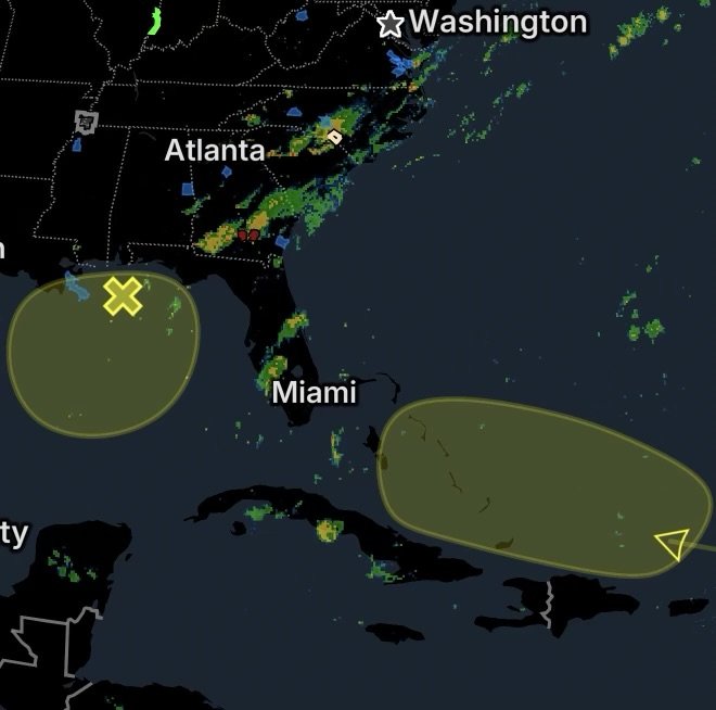
The Atlantic tropics remain active as the remnants of Tropical Storm Dolly move westward to west-northwestward east of the Leeward Islands, while a separate weak area of low pressure produces disorganized showers and cloudiness across portions of the northeastern and north-central Gulf Coast.
Although tropical development is not currently expected to be significant, both disturbances could produce periods of locally heavy rain and gusty winds. Therefore, residents and travelers in the potential impact areas should continue monitoring the forecast over the next several days.
Remnants of Dolly East of the Leeward Islands
The remnants of Tropical Storm Dolly are located several hundred miles east of the Leeward Islands.
The system is moving quickly westward to west-northwestward at approximately 25 mph. Because of the system’s fast forward motion and environmental conditions, redevelopment into a tropical cyclone is considered unlikely.
However, a lack of tropical redevelopment does not mean the disturbance will have no impacts.
Locally Heavy Rain and Gusty Winds Possible
As the tropical wave approaches the Caribbean, it could bring:
- Periods of locally heavy rainfall
- Gusty winds
- Brief thunderstorms
- Reduced visibility during heavier downpours
- Ponding of water on roads
- Localized flooding in vulnerable locations
The Leeward Islands, Virgin Islands and Puerto Rico could experience impacts over the next several days.
Because tropical waves can produce concentrated bands of rainfall even without developing into named storms, residents should pay attention to local weather alerts and rainfall forecasts.
Why Rapid Tropical Redevelopment Is Unlikely
Tropical systems need a combination of warm ocean water, sufficient atmospheric moisture and favorable winds aloft to organize.
In this case, the remnants of Dolly are expected to continue moving quickly westward. That rapid movement gives the disturbance less time to organize while also making it more difficult for thunderstorms to consolidate around a defined circulation.
As a result, the primary concern is currently rainfall and gusty winds rather than tropical cyclone redevelopment.
Gulf Coast Disturbance Being Monitored
Meanwhile, a separate area of disorganized cloudiness and showers is affecting portions of the northeastern and north-central Gulf Coast.
The activity is associated with a weak area of low pressure that is expected to remain nearly stationary for the next several days.
Slow Development Possible
Unlike Dolly’s remnants, this Gulf Coast disturbance is expected to move very little. Development, if any, should be slow.
A nearly stationary weather system can still produce repeated rounds of showers and thunderstorms over the same general areas. Consequently, locally heavy rainfall could become a concern even if the disturbance never develops into a tropical depression or tropical storm.
Residents along portions of the Gulf Coast should monitor rainfall trends, particularly where soils are already saturated or drainage is poor.
Two Disturbances, Different Weather Threats
While both systems are being monitored in the tropics, their expected impacts are different.
Remnants of Dolly:
- Located east of the Leeward Islands
- Moving west to west-northwest near 25 mph
- Tropical redevelopment unlikely
- Locally heavy rain and gusty winds possible
- Leeward Islands, Virgin Islands and Puerto Rico could see impacts
Northeastern/North-Central Gulf Coast Low:
- Weak low-pressure area
- Disorganized showers and cloudiness
- Expected to remain nearly stationary
- Development, if any, should be slow
- Heavy rainfall could become the primary concern
What Residents Should Watch
Even when tropical development is unlikely, weather conditions can change quickly. Residents in the Caribbean should watch for rainfall and thunderstorm alerts, while Gulf Coast communities should pay particular attention to prolonged or repeated rainfall.
Drivers should never attempt to cross a flooded roadway. Just a small amount of moving water can make a vehicle difficult or impossible to control.
Travelers across the Caribbean should also be prepared for sudden downpours, gusty winds and temporary disruptions to outdoor activities.
Tropical Outlook: August 28, 2026
For now, neither disturbance represents an immediate indication of significant tropical cyclone development. However, weather systems can evolve as they move across different atmospheric environments.
The remnants of Dolly are expected to continue westward toward the Caribbean, where rainfall and gusty winds could become the main hazards. At the same time, the weak Gulf Coast low will be monitored for slow changes while it remains nearly stationary.
Radar Watch HQ will continue monitoring both disturbances for changes in organization, rainfall potential and impacts.
Radar Watch HQ Final Thoughts
The tropics do not have to produce a named storm to create hazardous weather. Heavy rain, thunderstorms, gusty winds and localized flooding can occur around weak tropical waves and areas of low pressure.
For the Caribbean, the remnants of Dolly are unlikely to redevelop but could still deliver locally heavy rainfall and gusty winds. Along the Gulf Coast, the weak low may linger for several days, increasing the potential for repeated rainfall.
Stay weather-aware, check local forecasts frequently and be prepared to act if watches or warnings are issued.
Radar Watch HQ will keep you updated as these systems move and the forecast evolves.