Strong Winds Along the Madison River Valley Combine With Dangerous Fire Weather in East Beaverhead
Southwest Montana is facing a combination of strong winds and critical fire-weather conditions Sunday, September 13, as the National Weather Service highlights hazardous conditions across portions of the Madison River Valley and East Beaverhead.
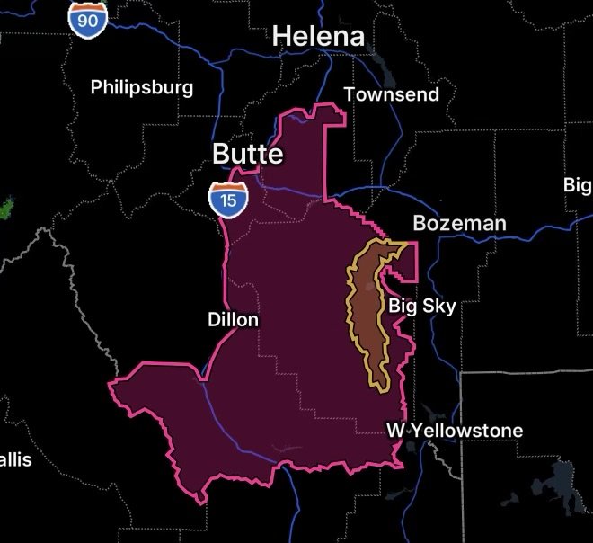
The Madison River Valley is under a high-wind threat affecting communities and travel corridors including Ennis, Jeffers, McAllister, Cameron and Norris. Forecast information from the National Weather Service indicates the potential for southwest winds around 30 to 40 mph, with gusts reaching as high as 60 mph. (National Weather Service)
At the same time, East Beaverhead is under a Red Flag Warning from noon through 9 p.m. MDT Sunday because of strong winds and very low relative humidity. The combination is capable of allowing any wildfire that starts to spread rapidly.
High Wind Concerns in the Madison River Valley
The Madison River Valley is expected to become particularly windy Sunday afternoon and evening. The Highway 287 corridor from Ennis toward Norris Hill could experience difficult travel conditions, especially for high-profile vehicles.
Strong crosswinds can make it difficult for drivers to maintain control, particularly for:
- Tractor-trailers and other large commercial vehicles
- Recreational vehicles
- Campers and travel trailers
- Box trucks and other high-profile vehicles
- Vehicles traveling through exposed areas
Drivers should reduce speed when strong crosswinds develop and maintain a firm grip on the steering wheel. Sudden gusts can cause vehicles to shift within their lanes or become difficult to control.
The National Weather Service’s forecast discussion indicated a significant probability of sustained winds reaching high-wind-warning levels in the Madison River Valley, with a substantial chance of gusts reaching 55 mph or greater. (National Weather Service)
Red Flag Warning for East Beaverhead
East Beaverhead faces a separate but related concern: critical fire weather.
The Red Flag Warning is in effect from noon through 9 p.m. MDT Sunday. Southwest winds are expected at 20 to 30 mph, with gusts up to 45 mph, while relative humidity is forecast to fall between 15% and 25%. (National Weather Service)
These conditions can cause fires to ignite more easily and spread rapidly once established. The National Weather Service specifically advises that outdoor burning is not recommended during the warning period. (National Weather Service)
A Red Flag Warning does not mean that a wildfire is currently burning. Instead, it means weather conditions are favorable for rapid fire growth if an ignition occurs.
Why the Combination Matters
Strong winds can create hazards beyond difficult travel. In dry areas, winds can rapidly push flames across grass, brush and other receptive fuels. They can also carry embers ahead of a fire, potentially allowing new fires to develop away from the main fire.
For communities and rural properties across the region, Sunday is a day to avoid unnecessary activities that could create sparks or flames.
Residents should:
- Avoid outdoor burning.
- Secure loose outdoor objects before winds increase.
- Keep vehicles away from dry grass when possible.
- Avoid activities that could create sparks.
- Have multiple ways to receive emergency information.
- Know evacuation routes if living near wildfire-prone areas.
- Keep important medications, documents and emergency supplies readily accessible.
Travel Safety Along Highway 287
Anyone traveling between Ennis and Norris should be prepared for rapidly changing wind conditions, particularly during the afternoon and evening.
High-profile vehicles should use extra caution, and travelers should consider whether their trip can be delayed until winds subside. Sudden gusts can be strongest in exposed locations and near gaps, ridges and open stretches of roadway.
If a vehicle becomes difficult to control, slow down safely and avoid abrupt steering or braking.
Stay Weather Aware
The combination of strong winds in the Madison River Valley and critical fire weather in East Beaverhead makes Sunday an important day for preparedness across southwest Montana.
Weather conditions can change quickly, and warnings may be upgraded, extended or adjusted as the event develops. Continue monitoring official National Weather Service information and instructions from local emergency-management and fire officials.
Radar Watch HQ will continue tracking the latest weather developments and providing updates as conditions evolve. Stay alert, stay prepared, and take changing wind and fire conditions seriously.