Flood Threat Expands Across the Midwest
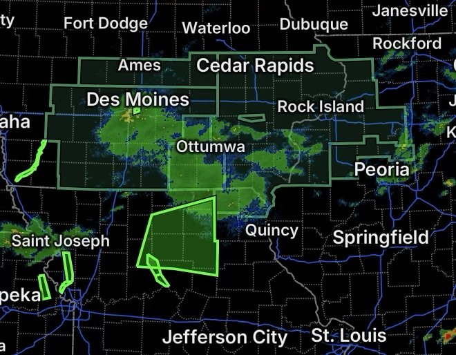
A widespread flood threat is developing across parts of Illinois, Iowa and northeast Missouri as additional rounds of heavy rainfall move across an already saturated region. The National Weather Service has issued and extended multiple Flood Watches and Flood Warnings, with concerns ranging from flash flooding and excessive runoff to rising rivers and streams.
The greatest concern is that soils are already holding significant moisture. Additional heavy rainfall can quickly increase runoff into creeks, streams and rivers, while urban and poor-drainage areas may experience flooding before larger waterways reach their peaks.
Flood Watch for Illinois, Iowa and Northeast Missouri
A Flood Watch is in effect from 10 PM CDT Wednesday through Thursday morning across portions of Illinois, Iowa and northeast Missouri. The National Weather Service says flooding from excessive rainfall is possible.
Illinois
The watch includes:
- Bureau County
- Carroll County
- Henderson County
- Henry County
- Mercer County
- Putnam County
- Rock Island County
- Warren County
- Whiteside County
Rainfall of 1 to 3 inches is expected in the broader watch area, with rainfall rates occasionally reaching 1 to 2 inches per hour. Localized totals of 3 to 5 inches are possible, particularly along the Interstate 80 and Highway 30 corridors.
Those rainfall rates can overwhelm drainage systems and produce rapid rises in smaller waterways.
Iowa
The Flood Watch includes:
Benton, Cedar, Clinton, Des Moines, Henry, Iowa, Jackson, Jefferson, Johnson, Jones, Keokuk, Lee, Linn, Louisa, Muscatine, Scott, Van Buren and Washington Counties.
Communities including Cedar Rapids, Iowa City, Davenport, Muscatine, Clinton, Burlington, Fort Madison, Washington and surrounding areas are within the watch area.
Residents near creeks, streams and flood-prone roads should be prepared for changing conditions, especially overnight when additional heavy rainfall is expected.
Northeast Missouri
The Flood Watch also covers Clark and Scotland Counties in northeast Missouri.
Heavy rainfall in this region could produce excessive runoff and contribute to rises along local waterways.
Flood Watch Continues Across Central and Southern Iowa
A separate Flood Watch remains in effect across portions of central and southern Iowa through Thursday morning.
The National Weather Service says showers are already occurring across portions of the region, while another band of heavier rain is expected overnight. Saturated ground means less additional rainfall may be needed to produce flash flooding.
The watch includes areas around Des Moines, Ames, Marshalltown, Pella, Newton, Oskaloosa, Ottumwa, Indianola, Creston, Atlantic, Winterset and surrounding communities.
The combination of saturated soils, repeated rainfall and rising waterways creates the potential for both flash flooding and additional river rises.
Flood Warning for Southwestern Iowa
A Flood Warning is in effect for southeastern Fremont County and western Page County in southwestern Iowa because of flooding along the East Nishnabotna River near and north of Riverton.
Flooding is affecting low-lying areas near the river, including locations around Riverton and along 250th Street west of the community.
Residents in flood-prone locations should avoid entering flooded areas and follow any road closures or instructions from local officials.
Flood Warning for Stranger Creek at Easton
A Flood Warning has also been issued for Stranger Creek at Easton, Kansas.
The warning calls for moderate flooding from Wednesday afternoon into Friday morning. Rising water could affect low-lying areas and roads around Easton, with higher river stages capable of producing increasingly significant impacts.
Anyone near Stranger Creek should monitor river conditions and avoid attempting to cross flooded roads.
Flood Warning for the Grand River Near Sumner
The Grand River near Sumner is also being monitored under a Flood Warning. The river affects portions of Carroll, Chariton, Livingston and Linn Counties in Missouri.
Additional rainfall across the region could contribute to further rises on the river and surrounding tributaries.
Flood Warning for the Raccoon River at Des Moines
A Flood Warning remains in effect for the Raccoon River at Des Moines Fleur Drive, covering the stretch from Walnut Creek to the Des Moines River.
The National Weather Service reports that minor flooding is occurring, with the river forecast to fall below flood stage later Wednesday. Even as water levels begin declining, flooding can continue along low-lying areas, trails and locations adjacent to the river.
What Residents Should Watch For
With multiple rounds of rainfall possible, conditions can change quickly. Residents in areas covered by the Flood Watch should:
- Monitor updated forecasts and Flood Warnings.
- Avoid driving through flooded roadways.
- Never drive around barricades or road closures.
- Move to higher ground if flooding threatens your location.
- Keep children and pets away from swollen creeks and rivers.
- Be especially cautious overnight when visibility is reduced.
- Have multiple ways to receive weather alerts in case conditions deteriorate quickly.
The National Weather Service emphasizes that most flood deaths occur in vehicles. Turn around, don’t drown when encountering a flooded roadway.
Radar Watch HQ Final Thoughts
The flood threat across Illinois, Iowa and northeast Missouri is being driven by more than just one round of rainfall. Saturated ground, repeated heavy rain and already elevated waterways can combine to make additional rainfall much more impactful.
Residents within the Flood Watch areas should remain weather-aware through Thursday morning, while people near rivers and streams under Flood Warnings should monitor water levels and be prepared to move away from flooding if conditions worsen.
For the latest warnings, watches and changing river conditions, continue monitoring updates from the National Weather Service and local emergency officials.