Flooding Expands Across Ohio and Indiana as Heavy Rain Swells Creeks, Streams and Rivers
Flood Watches, Flood Warnings and Flash Flood Warnings remain in effect as additional rainfall threatens already saturated areas across west central Ohio, northern Indiana and northwest Ohio.
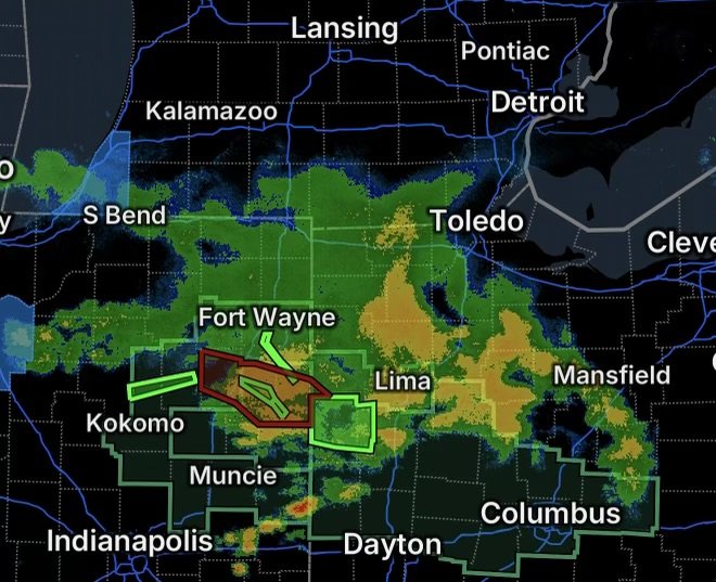
Heavy rainfall and thunderstorms are creating a widespread flooding concern across parts of Ohio and Indiana today, September 17, 2026. The National Weather Service has issued and maintained multiple Flood Watches, Flood Warnings and Flash Flood Warnings as repeated rounds of rain move across areas that have already received significant rainfall.
The combination of saturated ground, additional thunderstorms and heavy downpours is increasing the potential for rapid rises on creeks and streams, roadway flooding and additional river flooding.
Flood Watch — Central and West Central Ohio
A Flood Watch covers portions of central and west central Ohio, where excessive rainfall could produce additional flooding.
The central Ohio portion includes Delaware, Franklin, Licking, Madison and Union Counties.
The west central Ohio portion includes Auglaize, Champaign, Clark, Darke, Hardin, Logan, Mercer, Miami and Shelby Counties. The watch is in effect through 2 PM EDT Thursday.
Multiple rounds of showers and thunderstorms are expected to move across portions of the region, with heavier rainfall potentially occurring in bands. Excessive runoff could overwhelm drainage systems and produce flooding in rivers, creeks, streams and other low-lying locations.
Communities near waterways, poor-drainage areas and locations that have already received heavy rain should remain particularly alert.
Flood Warning — Auglaize, Mercer and Shelby Counties
A Flood Warning is in effect for northwestern Auglaize County, Mercer County and northwestern Shelby County in west central Ohio.
The warning replaces an earlier Flash Flood Warning and is in effect until 4:45 PM EDT Thursday. The National Weather Service reports that flooding is ongoing or expected to begin shortly, with radar showing heavy rain from thunderstorms. Between 2.5 and 3.5 inches of rain had fallen in the warned area, with additional rainfall possible.
Locations that may experience flooding include Celina, St. Marys, Coldwater, New Bremen, Rockford, Wabash, Mendon, Chickasaw, Montezuma, Tama, Neptune, Carthagena, Bulkhead, Chattanooga and Kossuth, among other communities.
Flooding can affect low-lying roads, creeks, streams and areas with poor drainage even after the heaviest rainfall has moved away.
Flash Flood Warning — Northern Indiana and Southwestern Ohio
A separate Flash Flood Warning covers portions of Adams, Huntington and Wells Counties in Indiana and southwestern Van Wert County in Ohio.
The warning includes numerous communities and locations:
Huntington, Bluffton, Decatur, Berne, Ossian, Geneva, Andrews, Markle, Monroe, Lancaster, Preble, Nottingham, Zanesville, Willshire, Uniondale, Wren, Poneto, Vera Cruz, Murray and North Oaks.
The National Weather Service reported that 2 to 5 inches of rain had fallen since the previous night, with additional rainfall possible as heavier showers and thunderstorms move through. Flash flooding was already occurring when the warning was updated.
Because flash flooding can develop quickly, people in the warned area should avoid flooded roads and move to higher ground when flooding threatens.
Wabash River Flooding Near Bluffton, Indiana
River flooding is also becoming an important part of the situation.
A Flood Warning remains in effect for the Wabash River near Bluffton, Indiana, affecting Wells County. Minor flooding was occurring, with additional rises forecast.
The river was reported at 10.5 feet and rising early Thursday morning, above the 10-foot flood stage. The forecast called for the river to crest around 12.4 feet Thursday evening before gradually falling below flood stage Sunday evening.
At higher river levels, water can reach roads and other low-lying areas near the river. Residents and travelers should never attempt to cross a flooded roadway.
Flood Watch — Northern Indiana and Northwest Ohio
A separate Flood Watch covers portions of northern Indiana and northwest Ohio through 2 PM EDT Thursday.
The watch includes portions of Whitley, Allen, Miami, Wabash and Huntington Counties in Indiana, along with Van Wert and Allen Counties in Ohio.
This area has already received significant rainfall, with the National Weather Service reporting 1 to as much as 5 inches of rain across portions of the watch area. Another 1 to 2 inches, with locally higher amounts, could fall through early this afternoon.
Additional rainfall on already saturated ground can quickly increase runoff and worsen flooding along streams, creeks and urban drainage systems.
Why Flooding Could Continue
Today’s flooding threat is not limited to where the heaviest rain is falling at any given moment.
When soils become saturated, less rainfall can soak into the ground. More water instead runs across the surface and into drainage systems, creeks and rivers. Repeated thunderstorms can therefore produce rapid water-level increases even when individual storms are relatively short-lived.
For communities already dealing with flooded roads or swollen waterways, another round of heavy rain can make conditions worse with little warning.
Flood Safety Reminders
If you are in or near any of the watch or warning areas:
- Never drive through a flooded roadway. Turn around and find another route.
- Do not walk or drive around barricades blocking flooded roads.
- Stay away from fast-moving water, swollen creeks and drainage channels.
- Move to higher ground immediately if flooding begins near your location.
- Keep children and pets away from floodwater.
- Monitor updates from the National Weather Service and local emergency officials.
- Remember that water depth can be difficult to judge, and road surfaces may be damaged or washed out beneath floodwater.
The National Weather Service emphasizes that most flood deaths occur in vehicles, making the decision to avoid flooded roads especially important.
Radar Watch HQ Final Thoughts
Flooding remains an evolving concern across portions of Ohio and Indiana on September 17, 2026, with multiple watches and warnings addressing both ongoing flooding and the potential for additional heavy rainfall.
The greatest concerns include areas that have already received several inches of rain, locations near rapidly rising creeks and streams, low-lying roads, poor-drainage areas and communities along the Wabash River.
Conditions can change quickly during repeated thunderstorms. Stay aware of the latest official warnings, and if flooding reaches a roadway, turn around — don’t risk driving through it.
Stay weather-aware, stay informed and put safety first as additional rain moves across the region.