Multiple Coastal and Flood Hazards Affect the Region
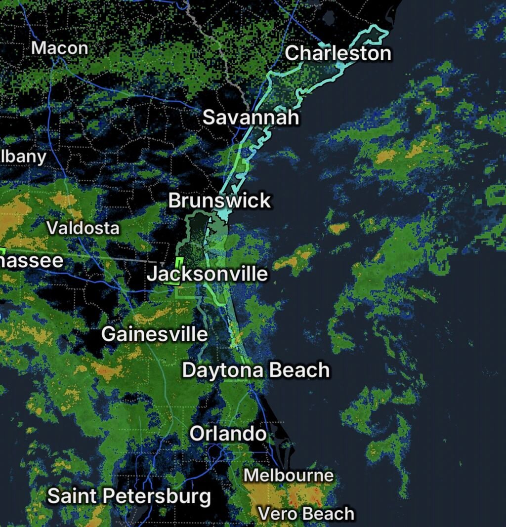
Several weather hazards are affecting portions of the South Carolina, Georgia, and northeast Florida coastlines on October 5, 2026.
A Rip Current Statement covers beaches in South Carolina, Georgia, southeast Georgia, and northeast Florida. At the same time, a Flood Watch is in effect for portions of northeast Florida and southeast Georgia, while a Flood Warning is in effect for the St. Marys River at Macclenny, Florida.
Residents, beachgoers, boaters, and anyone traveling through flood-prone areas should remain alert to changing conditions.
🏖️ Rip Current Statement for Area Beaches
The Rip Current Statement affects:
- South Carolina beaches
- Georgia beaches
- Southeast Georgia beaches
- Northeast Florida beaches
Rip currents are powerful channels of water moving away from the shoreline. They can pull swimmers away from the beach even when the water appears relatively calm.
Rip Current Safety
🏊 Do not swim against a rip current. If caught in one, remain calm and swim parallel to the shoreline until you escape the current, then swim toward shore.
🛟 Swim near a lifeguard whenever possible.
🚩 Pay attention to beach flags and posted warnings.
👀 Keep children under close supervision near the water.
If you cannot swim out of the current, float or tread water and signal for help.
🌧️ Flood Watch for Northeast Florida and Southeast Georgia
A Flood Watch covers portions of northeast Florida and southeast Georgia, meaning conditions are favorable for flooding to develop.
Heavy rainfall can overwhelm drainage systems, flood roadways, and cause water levels to rise in streams and low-lying areas.
Residents in flood-prone locations should monitor rainfall and water levels and be prepared to move to higher ground if conditions worsen.
🚨 Flood Warning — St. Marys River at Macclenny
A Flood Warning is also in effect for the St. Marys River at Macclenny, Florida.
Unlike a Flood Watch, a Flood Warning means flooding is occurring, imminent, or otherwise requires immediate attention.
People near the river and in low-lying areas should avoid entering flooded locations and follow instructions from local emergency officials.
🚗 Turn Around, Don’t Drown
Never drive through a flooded roadway.
Floodwater can hide washed-out pavement, debris, and other hazards. Even relatively shallow moving water can cause a vehicle to lose control.
Turn around, don’t drown!
🌊 Coastal and Inland Flooding Can Occur Together
The combination of coastal hazards and inland flooding means residents may face different dangers depending on where they are located.
Beachgoers should focus on dangerous currents and surf, while residents near rivers, creeks, and low-lying areas should monitor flood conditions.
Travelers should also be prepared for water-covered roads and rapidly changing conditions.
🛟 Safety Essentials
For beachgoers:
- Swim near a lifeguard.
- Follow posted beach warnings.
- Never underestimate a rip current.
- Avoid entering the water when conditions are dangerous.
For flood-prone areas:
- Monitor local weather and emergency alerts.
- Move to higher ground if flooding threatens.
- Never walk or drive through floodwater.
- Keep children away from flooded waterways.
- Do not attempt to cross flooded bridges or roads.
The Bottom Line
🌊 October 5, 2026: Rip Current Statements are affecting South Carolina, Georgia, southeast Georgia, and northeast Florida beaches, while a Flood Watch covers portions of northeast Florida and southeast Georgia.
🚨 The St. Marys River at Macclenny, Florida, is under a Flood Warning, adding an active river flooding concern to the regional hazards.
Stay out of dangerous surf, monitor flood alerts, and remember: Turn around, don’t drown!