Typhoon Saudel Nears Okinawa
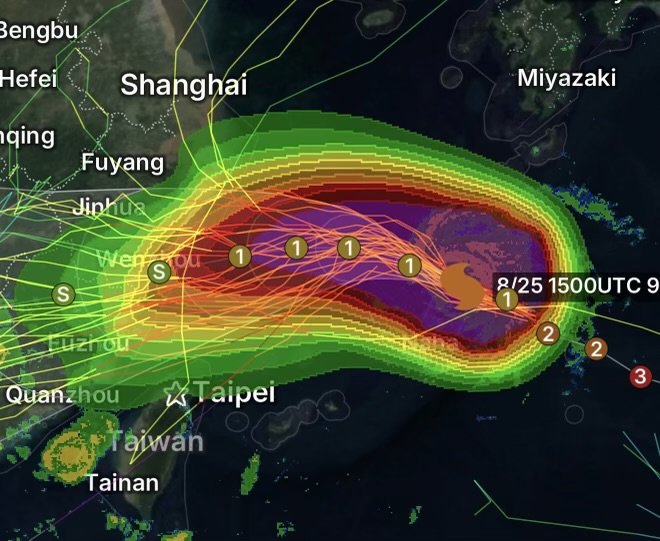
Category 2 Typhoon Saudel is moving west-northwest toward Okinawa, with the storm now significantly closer to Kadena Air Base and the Okinawa region.
The latest National Weather Service tropical cyclone advisory had Saudel with maximum sustained winds of 115 mph, moving west-northwest at about 14 mph. At that advisory time, the center was approximately 335 miles east of Okinawa, with the storm expected to pass near Okinawa as a Category 2 typhoon. (National Weather Service)
As Saudel continues approaching, residents and military communities across Okinawa should remain prepared for rapidly deteriorating conditions.
Saudel’s Strong Wind Field
Although the center of the typhoon may not pass directly over every part of Okinawa, its large wind field means significant impacts can extend well away from the eye.
The National Weather Service reported:
- Maximum sustained winds: 115 mph
- Typhoon-force winds: extending outward up to 90 miles
- Tropical-storm-force winds: extending outward up to 205 miles
- Movement: West-northwest at approximately 14 mph
Because tropical-storm-force winds extend hundreds of miles from the center, dangerous weather can arrive well before the eye approaches.
Conditions Around Kadena and Okinawa
Kadena Air Base and surrounding Okinawa communities are preparing for the storm’s approach. Kadena’s local weather information shows dangerous sea conditions in the area, while the installation directs residents to official sources for current typhoon readiness and Tropical Cyclone Condition of Readiness information. (Kadena Air Base)
For residents, the biggest concerns include damaging winds, torrential rainfall, flooding, dangerous surf and rapidly worsening marine conditions.
Loose outdoor objects should be secured, and residents should avoid unnecessary travel once conditions begin deteriorating.
Dangerous Seas and Coastal Conditions
Saudel is also creating hazardous marine conditions. Strong winds over the western Pacific can produce very rough seas, large waves and dangerous surf.
Boaters should remain in port and follow local marine restrictions. People should also stay away from beaches, rocky shorelines and exposed coastal areas during the storm.
Heavy Rain and Flooding Threat
Typhoons can produce intense rainfall even when the strongest winds remain offshore.
As Saudel approaches Okinawa, bands of heavy rain may repeatedly move across the region. These bands can produce rapid rainfall accumulation, reduced visibility, ponding on roadways and localized flooding.
Low-lying areas, drainage channels and locations prone to flooding should be monitored closely.
What Residents Should Do Now
Residents should complete preparations before the strongest winds arrive.
Before Conditions Worsen
- Secure outdoor furniture, decorations and other loose objects.
- Charge phones, batteries and emergency equipment.
- Keep several days of essential supplies available.
- Monitor official weather and emergency-management information.
- Avoid unnecessary coastal travel.
- Stay indoors when dangerous winds arrive.
- Never drive through flooded roads.
- Be prepared for possible power outages.
Most importantly, follow evacuation or emergency instructions issued by local authorities and military installations.
Forecast Calls for Gradual Weakening
The latest National Weather Service advisory indicated that Saudel was expected to weaken while continuing toward Okinawa, with a passage near the island occurring Tuesday night or early Wednesday as a Category 2 typhoon. (National Weather Service)
Even with weakening, however, a Category 2 typhoon remains capable of producing dangerous conditions. Weakening does not mean the threat disappears.
Radar Watch HQ Weather Watch
Radar Watch HQ will continue watching Typhoon Saudel as it approaches Okinawa and the Ryukyu Islands.
The key message for residents is simple: do not focus only on the storm’s category. Pay attention to the wind field, rainfall, marine conditions and local emergency guidance.
Conditions can deteriorate quickly as the storm approaches, and impacts can extend far from the center.
Radar Watch HQ Final Thoughts
Typhoon Saudel is approaching a heavily populated and strategically important part of the western Pacific, making preparedness especially important across Okinawa.
With typhoon-force winds extending outward from the center and tropical-storm-force winds reaching much farther, residents should be ready for dangerous weather even if the eye remains offshore. (National Weather Service)
Stay informed, stay indoors when conditions become dangerous, and rely on official local authorities for the latest instructions.
Stay weather aware and stay safe.