Multiple Weather Hazards Affect the Southeast
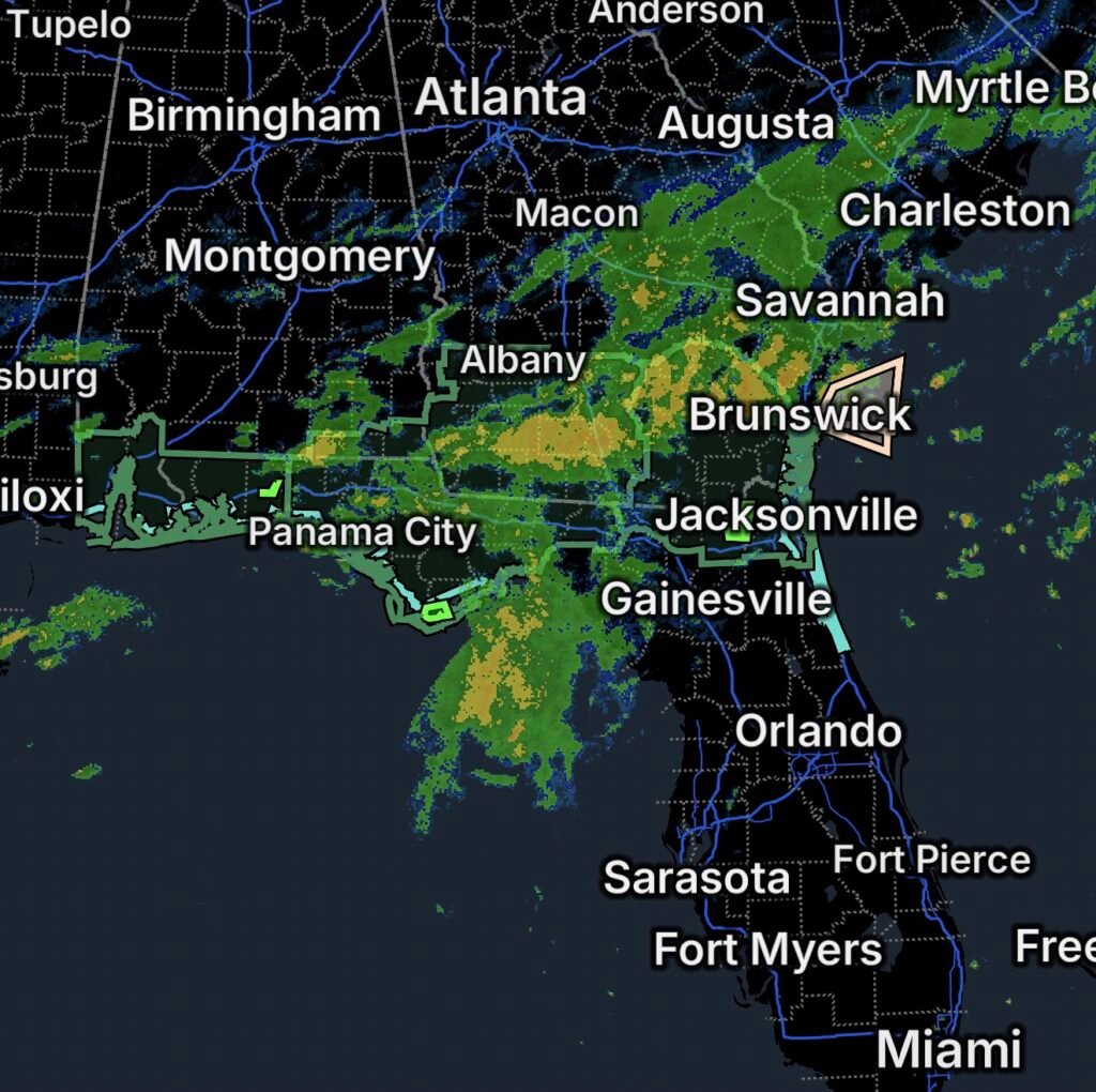
A broad area of unsettled weather is producing flooding, river flooding, hazardous marine conditions and dangerous surf across portions of Florida, Georgia and Alabama on Monday, October 5, 2026.
The most significant concerns include:
- 🌧️ Flood Watches across portions of northeast Florida and southeast Georgia
- 🌊 Flood Warning for the St. Marys River at Macclenny, Florida
- 🌧️ Flood Warning for southwestern Franklin County in Florida’s Big Bend
- 🚤 Marine Weather Statement for offshore Georgia waters
- 🏊 Rip Current Statement for northeast Florida beaches
- 🏖️ Rip Current Statement for coastal Alabama and northwest Florida
- 🌧️ Flood Watch for portions of southwest Alabama and northwest Florida
The National Weather Service Jacksonville currently has a Flood Watch covering numerous counties in northeast Florida and southeast Georgia through Monday evening, with flooding from excessive rainfall remaining possible. (National Weather Service)
🌧️ Flood Watch — Northeast Florida and Southeast Georgia
The Flood Watch includes portions of northeast Florida and southeast Georgia.
Florida areas include:
- Baker County
- Coastal Duval County
- Coastal Nassau County
- Eastern Hamilton County
- Inland Nassau County
- Northern Columbia County
- South Central Duval County
- Trout River
- Western Duval County
- Western Hamilton County
Southeast Georgia areas include:
- Appling
- Atkinson
- Bacon
- Brantley
- Clinch
- Coastal Camden
- Coastal Glynn
- Coffee
- Echols
- Inland Camden
- Inland Glynn
- Jeff Davis
- Northeastern Charlton
- Northern Ware
- Pierce
- Southern Ware
- Wayne
- Western Charlton
The National Weather Service says flooding caused by excessive rainfall remains possible in the watch area. The watch was extended through Monday evening, October 5. (National Weather Service)
Additional rainfall is possible across the region, increasing the potential for water to collect on roads, overwhelm drainage systems and cause flooding in low-lying areas.
🌊 Flood Warning — St. Marys River at Macclenny
A Flood Warning is in effect for the St. Marys River at Macclenny, Florida.
River flooding can persist even after the heaviest rainfall has ended because water continues moving downstream through the watershed.
Residents near the river should avoid entering or crossing flooded areas and should closely monitor updated river forecasts.
🚗 Turn Around, Don’t Drown
Never drive through a flooded roadway.
Even shallow moving water can sweep vehicles from the road, while flooded roads may conceal washed-out pavement, debris or other hazards.
🌧️ Flood Warning — Southwestern Franklin County, Florida
A separate Flood Warning is affecting southwestern Franklin County in Florida’s Big Bend.
Flooding in this part of the state can affect low-lying roads, drainage areas and communities near waterways.
Residents should remain alert for rapidly changing conditions, particularly where heavy rain continues or additional storms develop.
🚤 Marine Weather Statement — Offshore Georgia
A Marine Weather Statement is affecting waters from Savannah, Georgia, to Altamaha Sound, Georgia, extending out 60 nautical miles.
Marine conditions can deteriorate quickly when showers and thunderstorms move across offshore waters. Boaters should monitor marine forecasts and be prepared to seek safe harbor if storms strengthen.
A separate marine forecast for the offshore waters indicates increasingly hazardous conditions, with northeast winds strengthening and seas building. A Gale Watch is in effect for the offshore waters from late Monday night through late Tuesday night, with forecast gusts potentially reaching 40 knots and seas building as high as 8–10 feet Tuesday afternoon. (National Weather Service)
⚠️ Boaters Should Use Extra Caution
Before heading offshore:
- Check the latest marine forecast.
- Make sure communication equipment is working.
- Wear a properly fitted life jacket.
- Avoid thunderstorms and rapidly building seas.
- Have a route back to safe harbor.
- Do not underestimate increasing winds and wave heights.
🏊 Rip Current Statement — Northeast Florida Beaches
A Rip Current Statement is affecting the Northeast Florida Beaches.
The National Weather Service has issued a High Rip Current Risk beginning Tuesday afternoon and continuing through late Wednesday night for coastal Nassau, coastal Duval, coastal Flagler and portions of St. Johns County. (National Weather Service)
Rip currents can pull swimmers away from shore into deeper water, even when waves appear manageable.
🏖️ Beach Safety
- Swim near a lifeguard.
- Never swim alone.
- Stay out of the water when conditions become dangerous.
- If caught in a rip current, do not swim directly against it.
- Stay calm and float while allowing the current to carry you away from the beach.
- Once free of the current, swim parallel to the shoreline before returning to shore.
🌊 Rip Current Statement — Alabama and Northwest Florida
A separate Rip Current Statement affects portions of the Gulf Coast, including:
Alabama
- Mobile Coastal County
- Baldwin Coastal County
Florida
- Escambia Coastal County
- Santa Rosa Coastal County
- Okaloosa Coastal County
The National Weather Service Mobile/Pensacola office is also highlighting increasing rip-current concerns, with the risk expected to rise to High for area beaches Tuesday afternoon and beyond. (National Weather Service)
Beachgoers should check local beach flags and lifeguard instructions before entering the water.
🌧️ Flood Watch — Southwest Alabama and Northwest Florida
A Flood Watch is also affecting portions of southwest Alabama and northwest Florida.
The region has already experienced periods of heavy rainfall, and additional showers and thunderstorms could produce localized flooding.
The National Weather Service Mobile forecast discussion notes that showers and locally heavy rainfall are expected to gradually diminish, but localized flooding remains possible. (National Weather Service)
Motorists should be especially careful on roads that frequently flood and should never attempt to cross moving water.
🌊 Gulf Coast Weather Remains Unsettled
The combination of saturated ground, additional rainfall, elevated rivers and hazardous coastal conditions means residents and visitors across the Southeast should remain weather-aware.
Coastal residents should also monitor the latest forecasts because conditions over the Gulf and Atlantic can change quickly during periods of unsettled weather.
🚨 Essentials — What Residents Should Do
🌧️ If you’re under a Flood Watch: Be prepared to move to higher ground if flooding develops.
🌊 If you’re near a river: Follow river forecasts and never walk or drive through floodwater.
🚗 If roads flood: Turn around, don’t drown.
🏖️ If you’re visiting the beach: Check beach flags and stay out of the water when dangerous rip currents are present.
🚤 If you’re boating: Monitor marine warnings and forecasts, especially with stronger winds and building seas expected offshore Georgia.
📱 Stay informed: Keep emergency alerts enabled and monitor updates from the National Weather Service and local emergency officials.
Bottom Line
🌧️ October 5, 2026, brings multiple weather hazards across parts of Florida, Georgia and Alabama.
Flood Watches cover portions of northeast Florida and southeast Georgia, while Flood Warnings affect the St. Marys River at Macclenny and southwestern Franklin County, Florida.
Along the coast, marine hazards and rip currents are also a concern. Offshore Georgia waters face increasingly rough conditions, while dangerous rip currents are expected along portions of the Florida and Alabama coasts.
Residents, boaters and beachgoers should monitor updated forecasts and take precautions before conditions worsen.
Turn around, don’t drown — and never underestimate the power of moving water.