Hawaii Watches a Developing Tropical System in the Pacific
Residents across the Hawaiian Islands are being urged to pay close attention to a developing tropical system far east-southeast of the state.
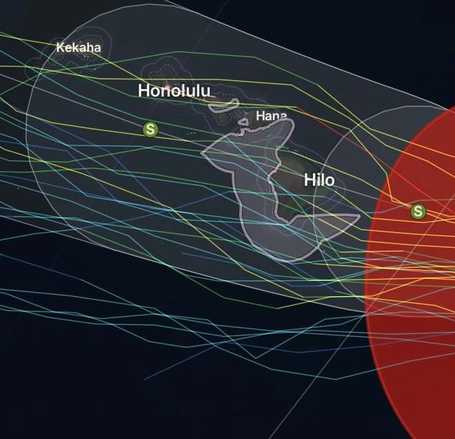
As of August 12, 2026, the National Hurricane Center is monitoring a low-pressure area located approximately 1,050 miles east-southeast of the Hawaiian Islands. Shower and thunderstorm activity remains disorganized, but environmental conditions are favorable for additional development.
Forecasters expect the system could become a tropical depression or tropical storm within the next day or so as it moves generally west-northwest at approximately 10 to 15 mph. The current formation probability is high, at 90% through 48 hours and 90% through seven days. (Reddit)
Why Hawaii Residents Should Pay Attention
The system is still far from the islands, and there is no indication at this time that a direct impact to Hawaii is certain.
However, its location and expected westward movement make it important for residents, visitors, businesses, and emergency managers to monitor future forecasts.
Tropical systems can change strength and direction as they move across the Pacific. A forecast that appears favorable several days in advance can become more concerning—or less concerning—as new observations and computer-model guidance become available.
Therefore, preparation should begin before watches or warnings are issued.
Potential Impacts to Watch
If the system continues developing and eventually approaches Hawaii, possible impacts could include:
Heavy Rain and Flash Flooding
Tropical moisture can produce periods of intense rainfall. Heavy rain may overwhelm drainage systems, produce rapid runoff and cause flash flooding, particularly in vulnerable areas.
Communities near streams, low-lying roads, steep terrain and flood-prone neighborhoods should remain prepared for changing conditions.
Strong Winds
A strengthening tropical cyclone could bring damaging winds if its circulation approaches the islands.
Residents should consider securing outdoor furniture, decorations, loose construction materials, trash containers and other objects that could become dangerous projectiles.
Dangerous Surf and High Waves
Even when the center of a tropical system remains offshore, large swells can spread outward.
Beachgoers, surfers, boaters and coastal communities should monitor marine forecasts because dangerous surf can develop before the storm reaches the islands.
Coastal Flooding and Storm Surge
A stronger tropical cyclone approaching Hawaii could create elevated water levels along vulnerable coastlines.
Coastal residents should know whether their homes or businesses are located in areas vulnerable to flooding and understand local evacuation guidance.
What Residents Should Do Now
This is the time to review hurricane preparedness—not wait until a storm is approaching.
Residents should:
- Check emergency supplies and replenish missing items.
- Keep several days of drinking water and nonperishable food available.
- Charge phones, portable batteries and other essential electronics.
- Review family communication plans.
- Know where to go if evacuation becomes necessary.
- Secure outdoor objects before strong winds arrive.
- Check flashlights, batteries and emergency radios.
- Review medications and other essential household supplies.
- Keep vehicles fueled or adequately charged.
- Monitor official forecasts from the National Weather Service, Central Pacific Hurricane Center and local emergency-management agencies.
Businesses and Communities Should Prepare Too
The potential threat is not limited to individual households.
Businesses, schools, hotels, hospitals, marinas, construction companies and public agencies should review emergency procedures and identify equipment or property that could be vulnerable to wind, flooding or heavy rain.
Maritime interests should also monitor changing conditions because tropical systems can produce dangerous seas well away from the center.
No Need for Panic—But Preparation Matters
The system is currently more than 1,000 miles from Hawaii, and its eventual track and intensity remain uncertain.
That means residents should not assume a major hurricane is headed toward the islands.
Instead, this is an opportunity to prepare while conditions are still relatively calm.
The National Hurricane Center specifically advises interests in the Hawaiian Islands to closely monitor the system as it moves west-northwestward. (Reddit)
Hawaii Tropical Threat: Stay Ahead of the Forecast
The Pacific can change quickly. A disturbance that begins as an area of disorganized thunderstorms can gradually develop a defined circulation and become a tropical depression or named storm.
For Hawaii, the most important information will be the system’s track, forward speed, organization and intensity during the coming days.
Residents should avoid relying on a single forecast model or social-media prediction. Instead, follow official updates as forecasters receive new satellite, aircraft, ocean and atmospheric observations.
Radar Watch HQ Weather Reminder
Now is the time to prepare—not panic.
Residents throughout the Hawaiian Islands should review their emergency plans and supplies while the tropical system remains far offshore. Even if the system ultimately weakens or turns away, preparedness can make a major difference during the next tropical threat.
Stay weather-aware, stay prepared and keep watching Radar Watch HQ for developing Pacific weather threats and severe-weather updates.
Forecast information can change. Always follow the latest instructions from local emergency officials and official National Weather Service products.