Tropical moisture could spark thunderstorms across coastal waters
A surge of tropical moisture will continue streaming across Southern California, creating a slight chance of thunderstorms over coastal waters. While widespread thunderstorms are not expected, isolated activity could develop with little warning, creating locally hazardous conditions for boaters.
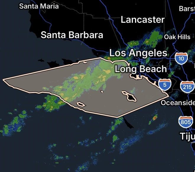
The marine weather concern covers a broad portion of the Southern California coastal waters, including both nearshore and offshore zones.
Areas Being Monitored
Inner Waters
The marine weather statement includes the inner waters from Point Mugu to San Mateo Point, as well as waters surrounding:
- Santa Catalina Island
- Anacapa Island
These waters could experience isolated showers or thunderstorms as tropical moisture moves overhead.
Outer Waters
The statement also covers the outer waters from Santa Cruz Island to San Clemente Island, extending up to 60 nautical miles offshore, including:
- San Nicolas Island
- Santa Barbara Island
Boaters traveling farther offshore should remain especially alert because thunderstorms can produce sudden changes in wind direction, stronger wind gusts, reduced visibility and locally rough seas.
Why Tropical Moisture Matters
Tropical moisture contains abundant atmospheric water vapor. As this moisture moves over the region, areas of instability can develop, particularly when other atmospheric lifting mechanisms are present.
As a result, even though the overall thunderstorm probability remains low, isolated thunderstorms can form over the ocean and may be difficult to detect from shore.
Thunderstorms over coastal waters can also produce lightning and sudden wind shifts well away from the heaviest rainfall.
What Boaters Should Watch For
Anyone operating a vessel in the affected waters should monitor weather conditions throughout the day.
Potential hazards include:
- Isolated thunderstorms
- Lightning
- Sudden wind gusts
- Rapid wind-direction changes
- Reduced visibility in heavy rain
- Locally rough or confused seas
- Sudden changes in boating conditions
Because marine thunderstorms can develop quickly, boaters should not rely solely on conditions observed when leaving the harbor.
Safety Tips for Southern California Boaters
If thunderstorms begin developing nearby, consider returning toward a safe harbor or protected waters before conditions deteriorate.
Before heading offshore:
- Check the latest marine forecast.
- Monitor NOAA Weather Radio or a reliable marine weather source.
- Keep communication equipment charged.
- Watch the sky for rapidly building clouds.
- Maintain a safe distance from developing thunderstorms.
- Be prepared for sudden wind and visibility changes.
- Always wear a properly fitted life jacket when conditions become hazardous.
Radar Watch HQ Final Thoughts
The slight chance of thunderstorms does not mean every part of the Southern California coastal waters will experience storms. However, tropical moisture can create an environment where isolated thunderstorms develop unexpectedly.
From the waters near Point Mugu and Anacapa Island to San Mateo Point, Santa Catalina Island, San Nicolas Island, Santa Barbara Island and San Clemente Island, mariners should remain weather-aware and be prepared for rapidly changing conditions.
For anyone planning an offshore trip, the safest approach is simple: check the marine forecast before departure and continue monitoring conditions while underway.
Stay weather-aware, stay prepared, and stay safe on the water.

Affiliate Disclosure: As an Amazon Associate, Radar Watch HQ earns from qualifying purchases.
Radar Watch HQ Top 5 Essential Emergency Preparedness Picks
Whether you’re preparing for severe thunderstorms, flash flooding, hurricanes, wildfires, or extended power outages, these five emergency essentials can help keep your household safer when severe weather strikes.
A portable power station provides reliable backup electricity during outages, allowing you to power phones, medical devices, laptops, lights, small appliances, and communication equipment without fuel.
Best for:
- Extended power outages
- Severe thunderstorms
- Hurricanes
- Winter storms
- Wildfires
2. Flood Protection Barriers & Sandless Flood Bags
Flood barriers help divert or absorb water before it enters garages, doorways, and low-lying areas. They deploy quickly and can help reduce property damage during flash flooding.
Best for:
- Flash Flood Warnings
- Heavy rainfall
- River flooding
- Coastal flooding
3. Rechargeable LED Flashlights
Bright, dependable flashlights are essential when the power goes out. Rechargeable or solar-powered models provide long-lasting illumination for navigating safely indoors and outdoors.
Best for:
- Overnight power outages
- Emergency evacuations
- Storm damage inspections
Keep phones, tablets, weather radios, and USB-powered devices charged when the electrical grid is unavailable. A solar power bank offers an additional charging option during prolonged emergencies.
Best for:
- Communication during outages
- Emergency weather alerts
- Travel and evacuation
A NOAA Weather Radio delivers official weather alerts directly from the National Weather Service, even when cellular networks or internet service are unavailable. It remains one of the most dependable ways to receive life-saving warnings.
Best for:
- Tornado warnings
- Severe thunderstorm warnings
- Flash flood warnings
- Hurricane alerts
- Winter storm emergencies
Why Radar Watch HQ Recommends These Essentials
At Radar Watch HQ, preparedness is just as important as staying informed. These five emergency essentials can help you stay connected, protect your property, and safely navigate severe weather events. Having supplies ready before storms arrive allows you to respond quickly when warnings are issued and conditions begin to deteriorate.