

















Northern Gulf Tropical Threat
The northern Gulf Coast is watching a developing tropical system that could become a short-lived tropical depression or tropical storm before reaching the Upper Texas or southwestern Louisiana coast on Tuesday. The National Hurricane Center is monitoring Invest AL97, an area of low pressure located more than 100 miles south of southern Louisiana.
The system is already producing a concentrated area of showers and thunderstorms with signs of organization. Additional development is expected as the low slowly moves west-northwestward toward the coast.
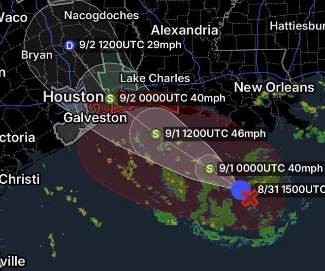
Potential Tropical Cyclone Five Near Louisiana
As of Monday morning, the disturbance was located approximately 130 miles south of Morgan City, Louisiana, over the northern Gulf.
The National Hurricane Center expects the system to continue organizing. A short-lived tropical depression or tropical storm could form before landfall Tuesday.
An Air Force Reserve reconnaissance aircraft is scheduled to investigate the system, providing additional information about its circulation, wind speeds, and organization.
Because conditions can change quickly with developing tropical systems, residents and businesses along the Upper Texas and southwestern Louisiana coasts should continue monitoring official forecasts.
Tropical Storm Watches or Warnings Possible
The potential for additional strengthening means tropical storm watches or warnings could be required later today for portions of the coast.
This is particularly important because impacts can occur even if the system does not become a named tropical storm.
The National Weather Service Houston/Galveston office is already highlighting the possibility of increased rainfall Tuesday, including locally heavy rainfall.
Tropical Storm Warning in Southwestern Louisiana
A Tropical Storm Warning is in effect for portions of the southwestern Louisiana coast, including:
- Cameron
- Creole
- Grand Chenier
Residents in these communities should closely monitor local emergency information and be prepared for deteriorating weather conditions.
Tropical-storm-force winds, heavy rainfall, reduced visibility, rough seas, and localized flooding can create dangerous conditions, particularly near the coast and waterways.
Heavy Rain and Flooding Threat
One of the biggest concerns from this system is rainfall.
The tropical disturbance contains deep tropical moisture, allowing thunderstorms to produce very high rainfall rates. Even if the circulation remains weak, repeated thunderstorms could cause water to accumulate quickly.
The National Weather Service expects locally heavy rainfall across portions of the Upper Texas and southwestern Louisiana coasts during the next several days.
A Flood Watch is in effect for a portion of southeast Texas, where additional rainfall could increase the risk of flooding.
Why Heavy Rain Can Become Dangerous
Tropical systems can produce rainfall far greater than their wind strength might suggest.
Slow movement is especially concerning because thunderstorms can repeatedly develop over the same communities. This can result in:
- Rapidly rising water
- Street flooding
- Poor drainage flooding
- Flooded low-lying areas
- Dangerous driving conditions
- Creeks and bayous rising
- Water entering vulnerable structures
Residents should never drive through flooded roadways. Even relatively shallow moving water can sweep vehicles from the roadway.
Southeast Texas and Houston-Galveston Area
The Upper Texas coast is one of the primary areas being monitored as the system moves west-northwestward.
Communities around the Houston-Galveston region could experience increasing showers and thunderstorms, with locally heavy rainfall possible. NWS Houston/Galveston is also monitoring the potential for tropical-storm watches or warnings along parts of the Upper Texas coast.
Galveston and surrounding coastal communities should also account for the combination of tropical moisture, thunderstorms, rougher marine conditions, and existing heat and air-quality concerns.
Air Quality Alert Across the Houston-Galveston Region
An Air Quality Alert is also affecting portions of the region, including:
- Inland Harris County
- Inland Brazoria County
- Inland Galveston County
- Coastal Harris County
- Coastal Brazoria County
- Coastal Galveston County
- Brazoria Islands
- Galveston Island
- Bolivar Peninsula
The tropical system therefore adds another layer of weather-related concern to an area already dealing with air-quality issues.
Residents who are sensitive to poor air quality should monitor local air-quality information and limit prolonged outdoor exposure when conditions warrant.
Marine Conditions Could Deteriorate
Boaters should pay particularly close attention to the system.
The National Hurricane Center’s offshore forecast indicates that near-gale-force winds and rough seas could develop in the nearshore waters, especially Monday afternoon into Monday night.
That means conditions could become hazardous for smaller vessels even before the system reaches tropical-storm strength.
Boaters should avoid unnecessary trips into increasingly rough Gulf waters and monitor updated marine forecasts, gale warnings, and tropical cyclone advisories.
What Gulf Coast Residents Should Do Today
With the system expected to approach the coast Tuesday, residents should use Monday to prepare rather than waiting for conditions to deteriorate.
Before the Weather Arrives
- Monitor the latest National Hurricane Center and National Weather Service updates.
- Know whether you live in a flood-prone or low-lying location.
- Secure loose outdoor objects.
- Charge phones and backup batteries.
- Keep flashlights available.
- Avoid unnecessary travel during periods of heavy rain.
- Review evacuation routes if you live in a vulnerable coastal area.
- Keep important documents protected from water.
- Never drive through flooded roads.
Most importantly, residents should remember that the strength of the tropical system does not determine the entire level of danger. A weak tropical depression can still produce dangerous flooding.
Tuesday Could Bring the Greatest Impacts
The system is expected to continue moving west-northwestward toward the Upper Texas and southwestern Louisiana coasts.
While the exact track and intensity can still change, the combination of tropical moisture, thunderstorms, coastal exposure, and potentially heavy rainfall makes Tuesday an important day for residents to remain weather-aware.
The National Weather Service is already emphasizing increased rainfall chances and locally heavy rainfall associated with the disturbance.
Residents should be prepared for additional watches, warnings, and advisories if the system becomes better organized.
Radar Watch HQ Final Thoughts
Invest AL97 is a system that Gulf Coast residents should take seriously, even if its eventual tropical classification remains uncertain.
The National Hurricane Center expects additional development, and a short-lived tropical depression or tropical storm could form before the system reaches the coast Tuesday.
For southwestern Louisiana and the Upper Texas coast, the primary concerns include tropical-storm-force winds, locally heavy rainfall, flooding, thunderstorms, rough Gulf waters, and rapidly changing conditions.
The best strategy is simple: prepare early, monitor official updates, and never underestimate flooding.
Radar Watch HQ will continue monitoring the system and its potential impacts across the Gulf Coast.

Radar Watch HQ Top 5 Marine Essentials
Affiliate Disclosure: As an Amazon Associate, Radar Watch HQ earns from qualifying purchases.
🌊 1. U.S. Coast Guard-Approved Life Jacket
A properly fitted life jacket is the most important piece of safety equipment for every passenger onboard.
Best for: Recreational boaters, anglers, kayakers, and paddleboarders.
⚓ 2. Marine Emergency Radio (NOAA Weather Radio)
Receive real-time NOAA Weather Radio alerts, marine forecasts, and emergency warnings—even when cell service is unavailable.
Best for: Offshore and coastal boating.
🔦 3. Rechargeable Waterproof LED Flashlight
A bright waterproof flashlight is essential for emergencies, low visibility, nighttime navigation, and signaling for help.
Best for: Every boat emergency kit.
🧰 4. Marine First Aid Kit
A waterproof first aid kit stocked with bandages, antiseptic, medications, and emergency supplies for injuries on the water.
Best for: Every vessel, regardless of size.
🧭 5. Waterproof Dry Bag
Protect phones, wallets, charts, keys, electronics, and emergency supplies from water damage during storms or rough seas.
Best for: Boaters, kayakers, paddleboarders, and beachgoers.
🛒 Radar Watch HQ Marine Safety Picks
Prepare before you head out on the water. Our recommended marine safety essentials can help keep you and your crew safe during changing weather conditions.